

 It is that time of year again when everyone looks towards the winter forecast, the most popular seasonal forecast of all, with the hurricane season forecast coming in close behind in interest. The winter forecast is so popular due to the interest in impacts from holiday travel to potential additional work opportunities, such as snow removal. Winter can create hazardous conditions, including arctic cold temperatures, blinding snowfall, and severe wind damage. Coastal flooding can become an issue with a string of nor’easters, enhancing beach erosion. Then there is the excitement of a heavy snowfall and the peaceful scene that follows for a short time after the snow ends.
This year’s forecast will be an interesting challenge as ENSO is expected to be weak, the northern Pacific sea surface temperatures are well above normal, and the potential for stratospheric disruption is very high.
This year, we’ll break up the discussion into specific sections to discuss all the factors for the upcoming winter. The following are the sections:
Section One (PREMIUM): El Niño Southern Oscillation. A discussion on tropical forcing, including the impacts of the MJO on the weather pattern.
Section Two (PREMIUM): Sea Surface Temperature Anomalies. A discussion on the impacts of developing sea surface temperature anomalies in the Indian Ocean, Pacific, and Atlantic Oceans.
Section Three (PREMIUM): Cryosphere Development. A discussion on the impacts of snow growth in Siberia, snow growth in Canada, and sea ice in the Arctic Ocean.
Section Four (PREMIUM): Stratospheric and Tropospheric Polar Vortex. A discussion on the state of the stratosphere, including winds, temperatures, and impacts on the 500 MB pattern.
Section Five (PREMIUM): Technical Forecast Overview
Section Six (PUBLIC): Expected storm tracks. Based on the forecast data, my expectations for storm tracks this winter.
Section Seven (PUBLIC): National Forecast. An overview of the winter from a national perspective.
Section Eight (PUBLIC): Northern Mid-Atlantic forecast, including expected snowfall ranges.
Thank you for your interest in NY NJ PA Weather Premium Consulting!
Now it's time to get your own personal meteorologist and stay ahead of the storm!
I WANT MY PERSONAL METEOROLOGIST!
SECTION SIX: EXPECTED STORM TRACKS
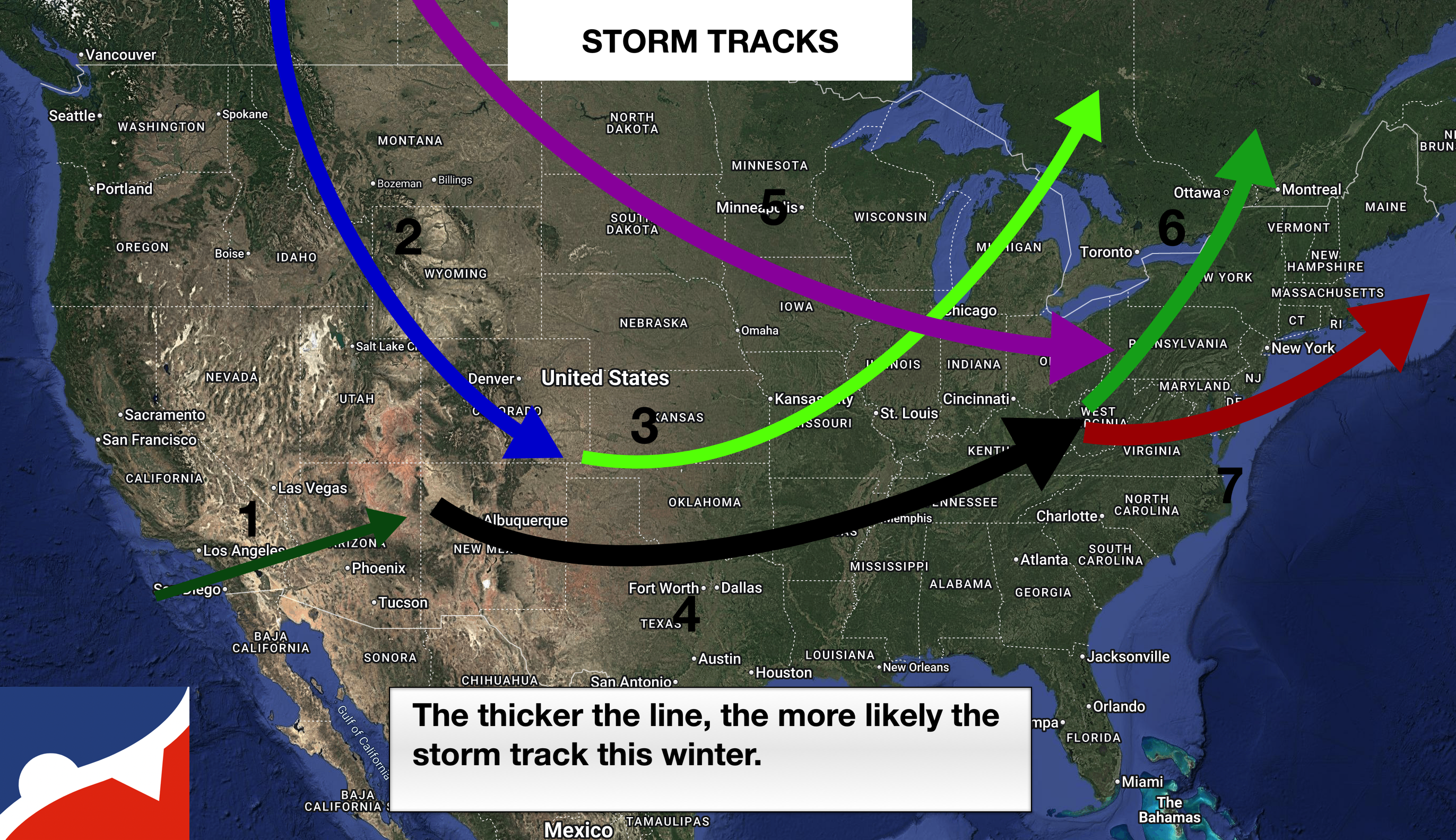
The primary storm track (4) will focus on the Southern Plains to the Tennessee River Valley, supporting a cold and stormy winter to the north of the dominant storm track. When the North Atlantic Oscillation is negative, the storm track will produce Miller-B type storms with a redeveloping low-pressure system over the southern Mid-Atlantic or over the coastal waters (7). This storm track will have the potential to produce significant winter storm impacts for the northern Mid-Atlantic and New England. When the North Atlantic Oscillation is positive, the storm track will lift into the Great Lakes (6), producing significant winter weather impacts in the Ohio River Valley and Great Lakes, while heavy rain will follow in the Mid-Atlantic and New England.
A secondary storm track will support Alberta Clippers (5) that will dive through the Northern Plains into the Ohio River Valley and then jump to the Mid-Atlantic Coast (7). Many of these low-pressure systems will be weak with minor to moderate wintry precipitation. However, a few low-pressure systems may be able to slow down and intensify if a negative NAO pattern develops. This storm track typically features a strong Polar or Arctic air mass that could produce lake effect snow in the Great Lakes.
A less frequent storm track will start in the Rockies (2) and dive into the Central Plains. If the pattern features an upper-level low-pressure system in eastern Canada, the storm track will fall into the Primary storm track (4). However, if the pattern is reloading and no upper-level low-pressure system is in place in eastern Canada, a storm track into the Central Great Lakes is likely with a strong cold front pressing to the East Coast. This storm track produces significant wintry weather in the Central/Northern Plains, Upper Midwest, and Western/Central Great Lakes.
A rare storm track due to La Nina influence will affect southern California and the Desert Southwest. This storm track will feature very weak low-pressure systems and typically focus most of the precipitation into Mexico.
SECTION SEVEN: NATIONAL FORECAST
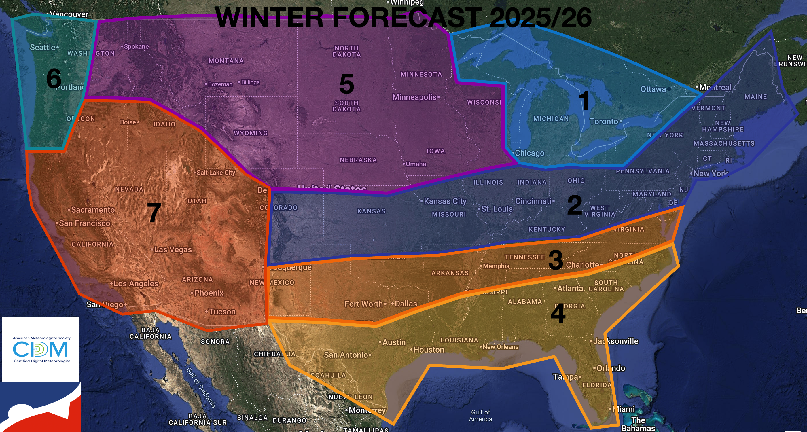 The winter of 2025/26 will be influenced by a very weak La Niña and the evolution of the Polar Vortex. This winter will start fast with active winter weather from December through mid-February. As La Niña fades to a neutral state through the winter, lingering winter impacts are possible into early March. Based on the observations over the past several weeks and known atmospheric influences, here is what is generally expected.
ZONE 1: Expect significant lake effect snowstorms to impact this region. Temperatures will be below normal. Precipitation will be near normal. The coldest period of the winter will be from December through mid-February.
ZONE 2: This zone will be on the cold side of the active storm track, with impacts ranging from significant snow, ice, and rain. Temperatures will be near to below normal, and precipitation will be above normal.
ZONE 3: This zone will be on the warm side of the active storm track, with impacts including rain, ice, and potentially thunderstorms. Temperatures will be near to above normal, and precipitation will be above normal.
ZONE 4: This zone will be under the influence of high pressure, and a storm track will move to the north and northwest. Temperatures will be above normal and precipitation below normal.
ZONE 5: This zone will feature several strong Polar and Arctic air masses with a storm track generally well to the south of the region. Temperatures and precipitation will be well below normal.
ZONE 6: Pacific storms will lift through or just north of this region with near-normal temperatures and above-normal precipitation.
ZONE 7: With storm tracks well to the north of the region, expect above-normal temperatures and below-normal precipitation.
SECTION EIGHT: NORTHERN MID-ATLANTIC FORECAST
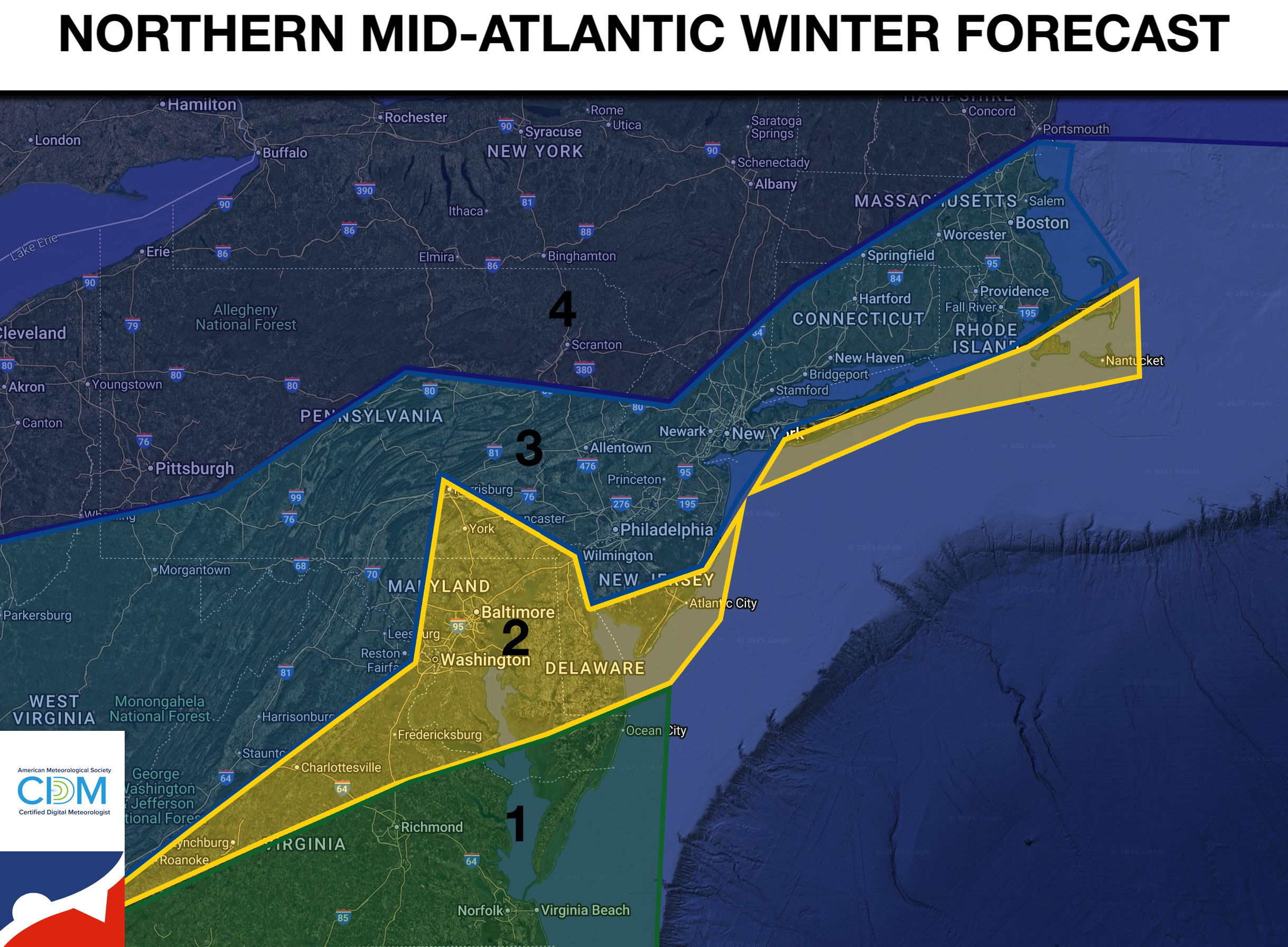
Now we zoom into the Northern Mid Atlantic! This winter will have a very similar feel to last year, although with a weaker La Niña, it will be slightly colder. The dominant type of storm that will impact the region will be a Miller-B type of storm. In this type of storm, many low-pressure systems will approach from the west or southwest and then redevelop either over eastern Virginia or the coastal waters of the Southern Mid-Atlantic. This factor means that many storms will feature a redeveloping precipitation shield along the coast, which can limit precipitation amounts in southeastern Pennsylvania, as the focus will be on the coast. This type of storm development can also feature warm air invading southern New Jersey, with the snow/mix/rain line lingering along the coast and then gradually shifting southward as the storm organizes.
ZONE 1: Expect near-normal temperatures and below-normal snowfall with the storm track mostly to the north and northeast of the region.
Expected seasonal snowfall: 5″-10″
ZONE 2: Most of the storm tracks will develop over this region, with impacts including multiple wintry mix phases and/or limited precipitation, as the best lifting will be focused to the east, such as in southeastern Pennsylvania. Expect near-normal temperatures and near-to-below-normal snowfall.
Expected seasonal snowfall: 10″-20″
ZONE 3: Most of the storm track will develop to the east of the region, with impacts that include snow and wintry mix phases and potentially significant snowstorms. I expect near-below-normal temperatures and near to above-normal snowfall.
Expected seasonal snowfall: 20″-40″
ZONE 4: This region will be in the heart of most cold air masses from storms this winter, with below-normal temperatures and above-normal snowfall, typically enhanced by high snowfall ratios.
Expected seasonal snowfall: 40″-80″


