UPDATED 09/26/26 10:32 AM
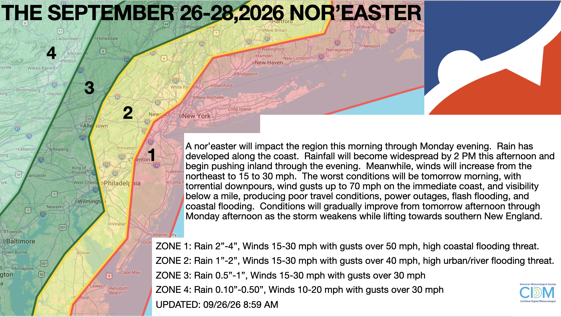
A powerful nor’easter will continue to bring waves of rainfall and strong winds, causing poor travel conditions, flooding, coastal flooding, wind damage, and power outages through tomorrow evening.
TODAY
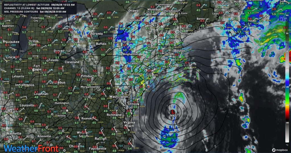
An intensifying low-pressure system will approach the region, and rainfall will become widespread by the afternoon. Winds will be from the northeast at 1o to 20 mph over the interior and 15 to 30 mph along the coast with gusts over 40 mph. High temperatures will range from the upper 50s to the lower 60s.
12 AM-2 PM: Rain will develop along the coast but remain widely scattered. A few showers could produce heavy downpours.
2 PM-12 AM: Scattered showers will develop over the interior. Periods of heavy rain and strong winds will increase from the Delaware River to the coast.
TONIGHT
A low-pressure area will produce periods of rain and windy conditions. Coastal flooding, urban flooding, wind damage, and very poor driving conditions are expected. Winds will back from the northeast to the north-northwest at 10 to 20 mph away from the coast and 15 to 30 mph along the coast with gusts over 40 mph. Low temperatures will range from the lower to mid-50s over the interior and mid-to-upper 50s along the coast.
TOMORROW
A low-pressure area will produce periods of rain and windy conditions. Coastal flooding, urban flooding, wind damage, and very poor driving conditions are expected. Winds will back from the northeast to the north-northwest at 10 to 20 mph away from the coast and 15 to 30 mph along the coast with gusts over 40 mph. High temperatures will range from the upper 50s to mid-60s.
12 AM-2 PM: Widespread showers over the interior. The worst of the storm will be along the coast during this period, with intense rainfall, strong winds, and coastal flooding.
2 PM-12 AM: Showers become more scattered throughout the region, and winds slowly subside.
TOMORROW NIGHT
The low-pressure system will exit the region with scattered showers and breezy conditions. Winds will be from the northwest at 5 to 15 mph. Low temperatures will range from the lower to mid-50s over the interior and upper 50s to lower 60s along the coast.
MONDAY
The low-pressure system will exit the region with scattered showers and breezy conditions. Winds will be from the west at 5 to 15 mph. High temperatures will range from the lower to mid-60s over the interior and mid to upper 60s along the coast.
TUESDAY
A trough will produce cloudy skies and isolated showers. Winds will be from the northwest at 5 to 15 mph. Low temperatures will range from the mid- to upper-50s. High temperatures will range from the mid- to upper-60s over the interior and lower to mid-70s along the coast.
WEDNESDAY
High pressure will produce clear skies to a few clouds. Low temperatures will range from the lower to mid-50s over the interior and mid to upper-50s along the coast. High temperatures will range from the lower to mid-70s over the interior and on Long Island and mid to upper 70s along the I-95 corridor.
THURSDAY
A warm front will produce variable cloud cover and scattered showers. Low temperatures will range from the upper 50s to lower 60s over the interior and lower to mid-60s along the coast. High temperatures will range from the lower to mid-70s on Long Island, mid to upper 70s over the interior, and upper 70s to lower 80s along the I-95 corridor.
FRIDAY
A cold front will move through in the morning with scattered showers. Skies will clear in the afternoon. Low temperatures will range from the lower to mid-50s over the interior, upper 50s to lower 60s in the suburbs, and lower to mid-60s in urban areas. High temperatures will range from the mid to upper 60s over the interior and lower to mid-70s along the coast.
SATURDAY
A stationary front with waves of low pressure will produce scattered showers over the interior and rain along the I-95 corridor and coast. Low temperatures will range from the upper 50s to lower 60s over the interior and lower to mid-60s along the coast. High temperatures will range from the mid- to upper-60s.