
UPDATED 09/01/26 9:11 AM
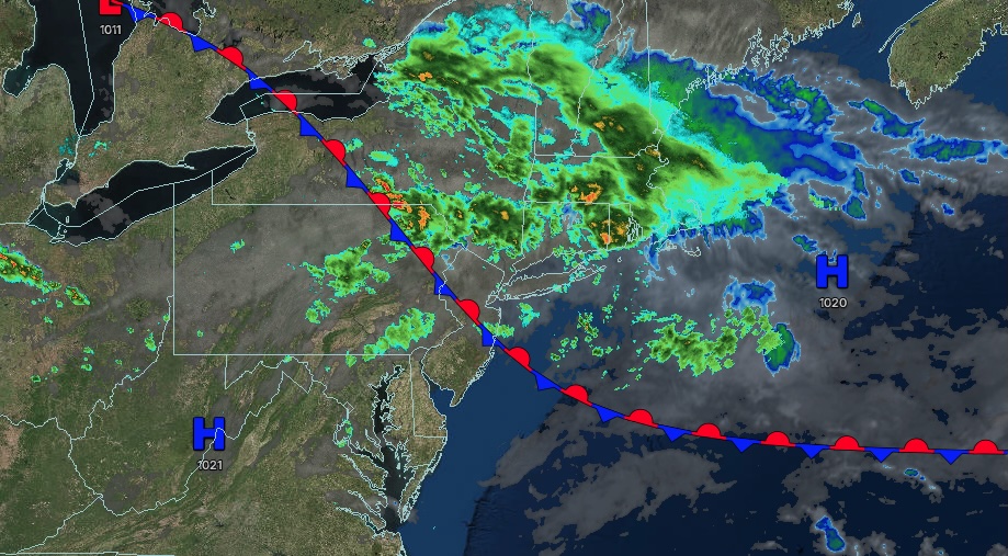
A wavering frontal boundary will bring a stormy pattern, with waves of showers and thunderstorms through Thursday. Thunderstorms could become severe, bringing wind damage, flash flooding, and poor travel conditions.
TODAY
A stationary front will produce variable clouds along with scattered showers and thunderstorms. Winds will be from the west at 5 to 10 mph. High temperatures will range from the upper 70s to lower 80s over the interior and Long Island, lower to mid-80s in the New York City metropolitan area, and upper 80s to lower 90s in the Philadelphia metropolitan area.
TONIGHT
A stationary front will waver over the region, with variable clouds and scattered showers and thunderstorms. Winds will be from the west at 1 to 5 mph. Low temperatures will range from the mid to upper 60s over the interior and suburbs and upper 60s to lower 70s in urban areas.
TOMORROW
A wavering frontal boundary will produce variable clouds along with scattered showers and thunderstorms. Winds will be from the southwest at 1 to 5 mph. High temperatures will range from the lower to mid-70s over the interior, mid to upper 70s in the New York City metropolitan area, and upper 70s to lower 80s in the Philadelphia metropolitan area.
TOMORROW NIGHT
A stationary front will waver over the region with variable clouds and scattered showers and thunderstorms. Winds will be light and variable. Low temperatures will range from the mid-to-upper 60s over the interior and the upper 60s to the lower 70s along the coast.
THURSDAY
A cold front will produce scattered showers and thunderstorms. Winds will be from the west at 5 to 10 mph. High temperatures will range from the mid to upper 70s on Long Island, lower to mid-80s over the interior and the New York City metropolitan area, and mid to upper 80s in the Philadelphia metropolitan area.
FRIDAY
A trough will produce scattered clouds and isolated showers. Winds will be from the northwest at 5 to 10 mph. Low temperatures will range from the mid-to-upper 60s over the interior and the lower to mid-70s along the coast. High temperatures will range from the mid-to-upper 70s on Long Island, lower to mid-80s over the interior and the New York City metropolitan area, and mid-to-upper 80s in the Philadelphia metropolitan area.
SATURDAY
A trough will produce scattered clouds and isolated showers. Low temperatures will range from the mid-to-upper 50s over the interior and the lower to mid-60s along the coast. High temperatures will range from the lower to mid-70s over the interior, the upper 70s to lower 80s in the New York City metropolitan area, the mid to upper 70s on Long Island, and the lower to mid-80s in the Philadelphia metropolitan area.
SUNDAY
A trough will produce scattered clouds and isolated showers. Low temperatures will range from the mid-to-upper 50s over the interior and the lower to mid-60s along the coast. High temperatures will range from the lower to mid-70s over the interior, the upper 70s to lower 80s in the New York City metropolitan area, the mid to upper 70s on Long Island, and the lower to mid-80s in the Philadelphia metropolitan area.
LABOR DAY MONDAY
A trough will produce scattered clouds and isolated showers. Low temperatures will range from the mid-to-upper 50s over the interior and the lower to mid-60s along the coast. High temperatures will range from the lower to mid-70s over the interior, the upper 70s to lower 80s in the New York City metropolitan area, the mid to upper 70s on Long Island, and the lower to mid-80s in the Philadelphia metropolitan area.
TUESDAY
A cold front will produce overcast skies and scattered showers. Low temperatures will range from the upper 50s to lower 60s over the interior and lower to mid-60s along the coast. High temperatures will range from the mid to upper 70s on Long Island, the lower to mid-80s in the New York City metropolitan area, the upper 70s to lower 80s in the interior, and the mid to upper 80s in the Philadelphia metropolitan area.


