
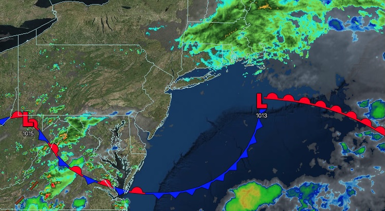
UPDATED 07/07/26 4:54 PM
Skies will clear tonight as dry air builds southward. Thunderstorms will return by the end of the week.
TONIGHT
A trough will produce scattered clouds and isolated showers. Winds will be from the northeast at 5 to 10 mph. Low temperatures will range from the upper 50s to the lower 60s over the interior and mid-60s along the coast.
TOMORROW
A trough will produce scattered clouds and isolated showers. Winds will be from the northeast at 5 to 10 mph. High temperatures will range from the upper 70s to the lower 80s over the interior and coast, and from the lower to mid-80s on the I-95 corridor.
TOMORROW NIGHT
High pressure will produce scattered clouds. Winds will veer to the southwest at 5 to 10 mph. Low temperatures will range from the mid to upper 60s.
THURSDAY
A warm front will approach the region, bringing increasing cloud cover and showers by the afternoon and evening. Winds will be from the southwest at 5 to 10 mph. High temperatures will range from the mid- to upper 70s on Long Island, the lower to mid-80s on the I-95 corridor, and the upper 70s to lower 80s over the interior.
FRIDAY
A cold front will approach the region in the morning, bringing increasing cloud cover and isolated showers. The cold front will produce showers and thunderstorms in the afternoon and evening. Low temperatures will range from the upper 60s to the lower 70s over the interior and the lower to mid-70s along the coast. High temperatures will range from the upper 70s to the lower 80s over the interior and from the mid to upper 80s along the coast.
SATURDAY
A trough will produce scattered clouds and isolated showers. Low temperatures will range from the mid to upper 60s over the interior and from the lower to mid-70s along the coast. High temperatures will range from the upper 70s to the lower 80s over the interior and from the lower to mid-80s along the coast.
SUNDAY
High pressure will produce scattered clouds. Low temperatures will range from the upper 50s to the lower 60s over the interior and mid to upper 60s along the coast. High temperatures will range from the mid- to upper 70s over the interior to the lower to mid-80s along the coast.
MONDAY
High pressure will produce scattered clouds. Low temperatures will range from the upper 50s to the lower 60s over the interior and mid-60s along the coast. High temperatures will range from the lower to mid-80s over the interior to the mid- to upper-80s along the coast.
TUESDAY
High pressure will produce scattered clouds with humid conditions. Low temperatures will range from the upper 60s to the lower 70s over the interior and from the lower to mid-70s along the coast. High temperatures will range from the upper 80s to the lower 90s over the interior and along the coast, and from the lower to mid-90s on the I-95 corridor.


