

Preface
We have just moved into the Atlantic hurricane season. There are all types of tropical systems but you don’t need a hurricane for the worst impacts and the highest death tolls. Flooding kills more people each year than wind. Tropical depressions, tropical storms and weaker hurricanes are capable of producing amazing rainfall totals than can kill hundreds of people and inflict unfathomable destruction.
Occasionally, a tropical weather system can interact with a mid-latitude system to produce excessive rainfall over a large area. Such was the case fifty four years ago and that is the topic of this week’s story.
Hurricane Agnes
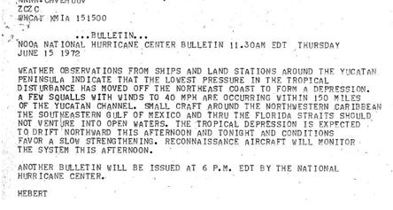
We begin on June 14, 1972, with an area of disturbed weather over the Yucatan Peninsula of Mexico. It was designated as a tropical depression on June 15th and the National Hurricane Center issued this bulletin.
 The depression continued to intensify on June 16th in the northwest Caribbean and it was named Tropical Storm Agnes. Agnes brushed by the western tip of Cuba before entering the Gulf of Mexico. Agnes was a large storm, with its impacts extending a whopping 2,000 miles from its center.
On June 17th, it was designated as a hurricane with maximum sustained winds of 75 mph. It remained Category 1 hurricane as it made landfall in the Florida Panhandle, near Cape San Blas.
With tides, up to six feet above average, coastal flooding and beach erosion along the Florida Panhandle resulted in 12 million dollars (95 million 2026 dollars) of damage. Agnes dumped up to nine inches of rain in the Naples area and seven inches around Tallahassee.
Six bridges connecting Cedar Key to the Mainland were under water. Sixteen homes at Alligator Point were swept off of their foundation. At least fifteen tornadoes were spawned by Agnes in Florida, One tornado at Okeechobee destroyed fifty mobile homes and killed 6 people. Another tornado was reported around the Kennedy Space Center. All told, there were nine fatalities reported in Florida.
Agnes weakened rapidly to a tropical storm and then it weakened further to a tropical depression as it moved inland over southeast Georgia. Forecasters were tracking Agnes as it was headed for the Carolinas on June 20th, but there was another weather system moving into the Great Lakes that raised concerns.
Rebirth With Devastating Flooding
At the same time that Agnes was moving to the Carolinas, an upper-level trough and a surface cold front were moving eastward from the Great Lakes. As the clock moved past midnight and the date changed from June 20th to June 21st, Agnes was only a remnant area of low pressure over eastern North Carolina. Energy from the mid-latitude ignited the remnants of Agnes and it began to intensify again.

An NWS surface weather map from June 21, 1972, showing a remnant low (Agnes) over eastern North Carolina and a frontal boundary from a mid-latitude weather system to the west.
Rain expanded rapidly, along with its intensity. Moisture moving in from the Atlantic was also injected into Agnes. Rainfall was extremely heavy over Virginia with amounts exceeding ten inches in the higher elevations. This resulted in severe flash flooding along the rivers.
Significant rain extended northward, all the way to the Southern Tier of New York. The River Forecast Center in Harrisburg, Pennsylvania, was monitoring the situation closely, fearing that there could be significant river flooding.
Meanwhile, Agnes became a tropical storm again as it slid out into the Atlantic and then proceeded to move northward. What would turn out to be an incredible natural disaster had commenced.
Flooding became severe in Virginia. In Richmond, four people were killed after their car plunged into the James River. A train that was headed for Washington, D.C. had to stop near Richmond because of the floodwaters and over 500 passengers were stranded.
A photo showing the floodwaters from Hurricane Agnes at Richmond, Virginia on June 23, 1972. Photo Credit-Library of Virginia-Public Domain.
At Pulaski, Virginia, the Peak River suffered severe flooding and water covered the rooftops of some houses. More than 600 miles of highways across the state were under water. Nearly 100 houses were destroyed and over 4,000 were damaged. Over 200 Virginia small businesses were damaged or destroyed.
On Interstate 95, the Purple Heart Bridge over the Occoquan River was damaged and closed when a barge, that was carried by floodwaters, rammed into it. There was severe flooding in the Washington, D.C. area at Alexandria.
Thirteen fatalities were reported in Virginia and 126 million dollars in losses.
Maryland also suffered severe impacts from Agnes. Near Baltimore, a car carrying a mother and her three children was swept off a highway by floodwaters. Firefighters manned rowboats to rescue her but all three children drowned.
There was severe flooding in the Patapsco River Valley with many roads, buildings and rail lines destroyed. More than 900 people were evacuated from their homes.
All roads that linked Anne Arundel County with Baltimore were closed. The Baltimore Beltway was also closed. The Conowingo Dam along the Susquehanna River recorded its all-time highest flow rate.
In Maryland, damage totaled to $110 million dollars (over 1 billion in 2026 dollars) and 19 fatalities were reported.
The storm dumped 16 inches of rain at Chantilly, Virginia, (just west of Washington, D.C.) 8.16 inches at Washington’s Reagan National Airport and 6.81 inches at Baltimore, Maryland.
Freshwater flooded the Chesapeake Bay killing large numbers of freshwater intolerant species which resulted in severe losses for the local seafood industry.
Meanwhile, Agnes barreled northward and it made its final landfall late on June 22nd as a tropical storm, During this period of time, Agnes was being absorbed by the upper-level trough to its west and it transitioned to an extratropical system.
The combination of a moisture-laden weather system with a trough aloft, a surface boundary, orographic lifting, and slow movement was a recipe for disaster over Pennsylvania and southern New York.
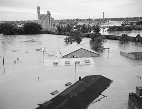
Friday, June 23rd was the worst day of this incredible event. Over a foot of rain fell in the Susquehanna River Basin in Pennsylvania. The river rose far faster than anyone could ever imagine. Thousands of residents fled from the rising flood waters. There were hundreds of water rescues.
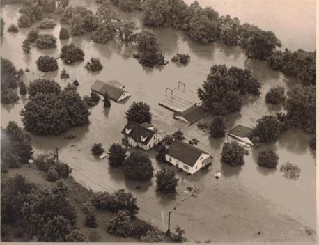 The photo shows severe flooding at Pottstown, Pennsylvania from Agnes in June 1972 . Photo Credit-pinterest.com
Flood waters, the likes of which had been never seen before, overwhelmed cities like Reading, where the Schuylkill River reached a record flood level of 31.5 feet and Harrisburg, where some buildings were under thirteen FEET of water.
More than a hundred Harrisburg YMCA campers and staff were evacuated using two CH-47 Chinook helicopters own by the National Guard at Camp Shikellimy located downstream of DeHart Dam in Middle Paxton Township.
 To the north, The Chemung River in southern New York reached flood levels and the waters rode rapidly from there. This left the cities of Corning and Elmira underwater. In Elmira, porches and garages were ripped apart and the Walnut St. bridge was carried away. Twenty thousand residents had to be evacuated. Much of the famous Corning Museum Of Glass was submerged in water.
The scope of this disaster continued to build upon itself from multiple sources. Flood waters from the Chemung River raced downstream into the Susquehanna River and flooded the Wyoming Valley of Pennsylvania. The Susquehanna River crested at 40.9 feet and the flood stage was about 22 feet. Over 100,000 residents of the Wilkes Barre area had to flee their homes due to a levee break.
It was a hectic and frustrating day at the River Forecast Center at the Federal Building in Harrisburg, Pennsylvania. There were substantial interruptions of electricity, water, and transportation services. They tried to provide updated reports but some of the information that they receive was erroneous.

Assessment And Recovery
Agnes is one f the costliest hurricanes on record in the U.S. with total damages of over 16 billion in 2026 dollars.
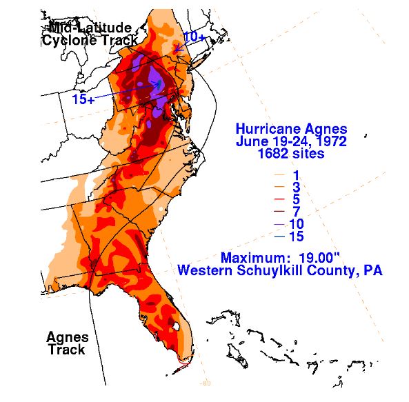 A map showing the track of Agnes and a mid latitude system and rainfall totals Map Credit : NOAA Weather Prediction Center.
President Nixon toured the flooded areas in Pennsylvania by helicopter. he called the “The greatest natural disaster in the history of the United States.”
Hurricane Agnes devastated the ailing railroads in the Northeast as floodwaters destroyed many rail lines. This led to the formation of the Conrail rail system, a federally funded railway that replaced the damaged and bankrupt lines that existed before the hurricane.
Hundreds of volunteers raced to the scene of the floods, from southern New York to Virginia, to aid in the cleanup and to provide services of suddenly homeless residents. The National Guard also assisted in this process.
The Army Corps of Engineers initiated several projects aimed at shoring up levees and dams in the Mid-Atlantic region. I can remember one such project around the Potomac River in Alexandra Virginia when I moved to the area in 1976.
In the end, fifteen states, and Washington, D.C. received at least some impacts from Agnes. Over 3,000 homes were destroyed and 110,000 homes were damaged to some extent. Over 5,000 mobile homes were damaged or destroyed. The death toll in the United States was 119 (50 of those were in Pennsylvania). Agnes became the first Category 1 hurricane to have its name retired.

