

UPDATED 06/11/26 9:53 AM
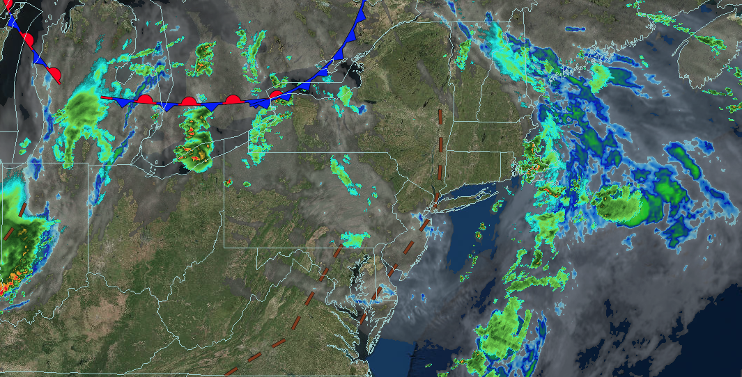
A tropical air mass will remain with hot and humid conditions, along with showers and thunderstorms, through tomorrow. Thunderstorms will be capable of reaching severe levels with frequent lightning, hail, wind gusts over 40 mph, and isolated tornadoes.
TODAY
A trough will produce scattered clouds and isolated thunderstorms. Winds will be from the west at 5 to 10 mph. High temperatures will range from the mid to upper 80s over the interior, lower to mid-90s on the I-95 corridor, and upper 80s to lower 90s along the coast and Long Island.
TONIGHT
A trough will produce scattered showers and thunderstorms through midnight, followed by areas of low clouds. Winds will be from the southwest at 5 to 15 mph. Low temperatures will range from the mid to upper 60s over the interior and lower to mid-70s along the coast.
TOMORROW
A trough will produce scattered clouds and isolated thunderstorms. Winds will be from the southwest at 5 to 15 mph. High temperatures will range from the mid to upper 80s over the interior, lower to mid-90s on the I-95 corridor, and upper 80s to lower 90s along the coast and Long Island.
TOMORROW NIGHT
A cold front will produce scattered showers and thunderstorms. Winds will veer to the west at 5 to 15 mph. Low temperatures will range from the upper 50s to lower 60s over the interior, mid to upper 60s in the suburbs, and upper 60s to lower 70s in urban areas.
SATURDAY
High pressure will produce scattered clouds. Winds will be from the northwest at 5 to 10 mph. High temperatures will range from the upper 70s to lower 80s over the interior and mid to upper 80s along the coast.
SUNDAY
High pressure will exit the region with scattered clouds. A cold front will produce showers and thunderstorms by the evening. Winds will be from the south at 10 to 20 mph with gusts up to 30 mph. Low temperatures will range from the lower to mid-60s over the interior and mid to upper 60s along the coast. High temperatures will range from the lower to mid-80s over the interior, upper 80s to lower 90s on the I-95 corridor, and lower to mid-80s along the coast and Long Island.
MONDAY
A trough will linger around the region with scattered clouds and isolated showers. Low temperatures will range from the upper 40s to lower 50s over the interior, mid to upper 50s in the suburbs, and upper 50s to lower 60s in urban areas. High temperatures will range from the upper 60s to lower 70s over the interior and lower to mid-70s along the coast.
TUESDAY
A trough will produce scattered clouds and isolated showers. Low temperatures will range from the lower to mid-50s over the interior and upper 50s to lower 60s along the coast. High temperatures will range from the lower to mid-70s over the interior, upper 70s to lower 80s on the I-95 corridor, and lower to mid-70s along the coast.
WEDNESDAY
A trough will produce scattered clouds and isolated showers. Low temperatures will range from the lower to mid-50s over the interior and upper 50s to lower 60s along the coast. High temperatures will range from the mid to upper 70s over the interior, lower to mid-80s on the I-95 corridor, and mid to upper 70s along the coast.
THURSDAY
A warm front will lift through the region with scattered clouds and isolated thunderstorms. A cold front will follow in the evening with widespread showers and thunderstorms. Low temperatures will range from the upper 50s to lower 60s over the interior and lower to mid-60s along the coast. High temperatures will range from the upper 70s to lower 80s over the interior, lower to mid-80s on the I-95 corridor, upper 70s to lower 80s along the coast, and mid to upper 70s on Long Island.

