

UPDATED 05/05/26 9:42 AM
Summer-like weather returns today, but won’t last as a cold front slowly sinks through the region tomorrow through Thursday morning. An unsettled weather pattern will continue through the weekend.
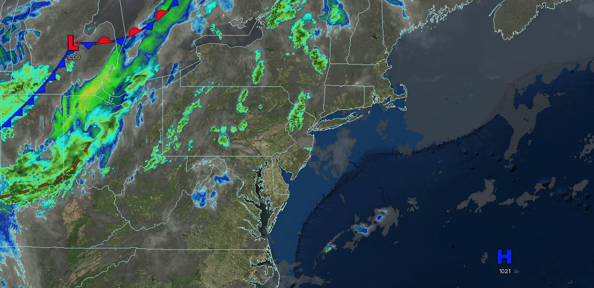
TODAY
High pressure will exit the region with increasing clouds. Winds will be from the southwest at 10 to 20 mph. High temperatures will range from the upper 60s to lower 70s in southeastern Long Island, lower to mid-70s in northwestern Long Island, upper 70s to lower 80s in the New York City metropolitan area, mid to upper 70s over the interior, and lower to mid-80s in the Philadelphia metropolitan area.
TONIGHT
A cold front will approach the region with increasing clouds. Winds will be from the southwest at 10 to 20 mph. Low temperatures will range from the upper 50s to lower 60s in the interior and suburbs and lower to mid-60s in urban areas.
TOMORROW
A cold front will slowly move through the region with scattered showers and thunderstorms. Winds will be from the southwest at 5 to 15 mph. High temperatures will range from the lower to mid-60s over the interior, mid to upper 60s in the northern suburbs of Philadelphia through the New York City metropolitan area, and lower to mid-70s in the Philadelphia metropolitan area and southern New Jersey.
TOMORROW NIGHT
A cold front will slowly move through the region with scattered showers. Winds will be from the southwest at 5 to 15 mph. Low temperatures will range from the upper 30s to lower 40s in higher elevations, mid to upper 40s over the interior, and upper 40s to lower 50s along the coast.
THURSDAY
A cold front will move off the coast with periods of showers in the morning, followed by variable clouds and isolated showers over the interior. Winds will veer to the northwest at 5 to 15 mph. High temperatures will range from the mid to upper 50s over the interior and lower to mid-60s along the coast.
FRIDAY
A trough will produce scattered clouds and isolated showers. Winds will be from the northwest at 5 to 15 mph. Low temperatures will range from the upper 30s to lower 40s over the interior and lower to mid-40s along the coast. High temperatures will range from the lower to mid-50s over the interior, the upper 50s to lower 60s in the northern suburbs of Philadelphia through the New York City metropolitan area, and the lower to mid-60s in the Philadelphia metropolitan area.
SATURDAY
A trough will produce variable clouds and isolated showers. Low temperatures will range from the mid to upper 40s over the interior and lower to mid-50s along the coast. High temperatures will range from the mid to upper 50s over the interior, mid to upper 50s on Long Island, and lower to mid-60s in the Philadelphia and New York City metropolitan areas.
SUNDAY
A trough will produce scattered clouds and isolated showers. Low temperatures will range from the upper 40s to the lower 50s. High temperatures will range from the mid to upper 60s in southeastern Long Island, lower to mid-70s in northwestern Long Island, upper 70s to lower 80s in the Philadelphia and New York City metropolitan areas, and lower to mid-70s over the interior.
MONDAY
A cold front and an area of low pressure will produce scattered showers. Low temperatures will range from the upper 40s to lower 50s over the interior, mid to upper 50s in the suburbs, and upper 50s to lower 60s in urban areas. High temperatures will range from the upper 50s to lower 60s over the interior, mid to upper 60s in the northern suburbs of the Philadelphia metropolitan areas and the New York City metropolitan areas, and upper 60s to lower 70s in the Philadelphia metropolitan area and southern New Jersey.
TUESDAY
A trough will produce scattered clouds and isolated showers. Low temperatures will range from the mid to upper 30s over the interior, lower to mid-40s in the suburbs, and mid to upper 40s in urban areas. High temperatures will range from the mid to upper 50s over the interior and Long Island and lower to mid-60s in the Philadelphia and New York City metropolitan areas.

