

There have been a number of historic tornado outbreaks in the U.S. over the years but what was referred to as the “Super Outbreak” , fifteen years ago, was the most deadly and catastrophic. There was widespread destruction over Alabama, Mississippi and Tennessee where over 175 tornadoes were recorded. .
The event spanned four days, From April 24th to April 28th. For this article I will mainly focus on the South. April 27th was the worst day with over 224 tornadoes. Incredibly, four were rated EF5 !
All told, there were with 362 confirmed tornadoes resulting in 324 direct fatalities and over 3,100 injuries. Alabama was the hardest hit state. It was also extremely costly with over billion dollars in damages (about 15 billion in 2026 dollars) !
An NWS map showing tornado tracks and intensity in the figure below.

Meteorological Conditions
If you were in a meteorology class and were asked what the ultimate situation would be for s massive tornado outbreak with a large death toll and damages, this would be it .
The event was triggered by a strong upper-level trough that swung into the southern Plains and Texas on April 25th. At the surface, low pressure developed rapidly in the Oklahoma/Texas area and it moved to the northeast to the Mississippi Valley with severe thunderstorms and some tornadoes likely.
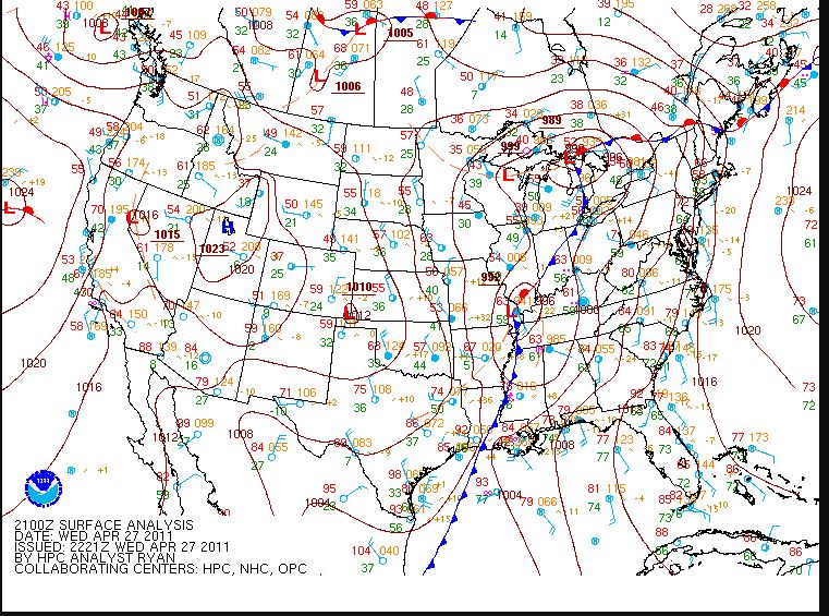
An HPC surface weather map for April 27,2011 showing low pressure crossing the Mississippi River with attending fronts.
Similar conditions were present the next day as the Storm Prediction Center indicated the likelihood of severe thunderstorms including an extended threat of strong to violent long-track tornadoes throughout the afternoon and evening. Helicity values (an indication of wind shear) were through the roof) !
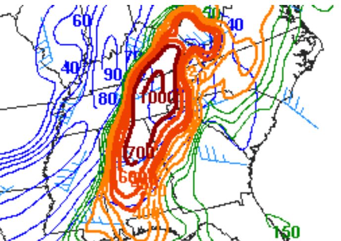
An NWS helicity map (indicative of strong atmospheric wind shear showing extreme conditions over parts of the southern U.S.
As the system moved eastward toward the Ohio, Mississippi, and Tennessee Valleys on April 27, a very powerful 80–100 knot mid-level jet stream, moved into the Ohio and Tennessee Valleys behind the trough and created strong wind shear along with a low pressure center moving quickly northeastward across those areas. Atmospheric instability was excessively high in the afternoon and evening. The Storm Prediction Center indicated moderate to high risk for severe thunderstorm from the Ohio and Tennessee Valleys southwestward to Mississippi and eastward to the Appalachians down into northern Georgia.
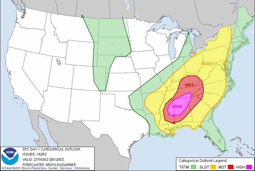
The SPC also indicated a high risk tornadoes from parts of eastern Mississippi to northern and central Alabama.
Al told, a whopping of 56 severe weather watches were issued by the SPC over the four days in the outbreak area. This included 41 tornado watches (10 of which were particularly dangerous situation) watch plus 15 severe thunderstorm watches.
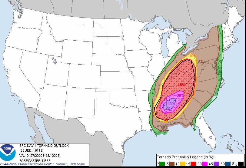
HPC tornado outlook map for April 27 to 28, 2011.
Tornado Impacts (By State)
Arkansas
The first deadly tornado was this long-tracked, high-end EF2 wedge tornado that struck the town of Vilonia 7:30 p.m. CDT on April 25th. A tornado emergency was declared shortly before the tornado struck. Four people were killed in the town and many more were injured. The tornado maintained EF2 intensity as it moved through through Vilonia, damaging numerous homes and businesses and flipping several semi-trucks. Following the tornado, 85 members of the U.S. National Guard were deployed to assist in search and rescue, debris clearing, security and traffic control.
Mississippi
A violent, fast moving and destructive tornado, which became the first EF5 tornado of the outbreak, touched down near Philadelphia, Mississippi on April 27 at 2:30 pm CDT and it stayed on the ground for almost 30 miles with a width of 1/2 mile . The tornado initially touched own just south of Jackson as an EF1. It went on through Neshoba, Winston and Noxubee counties Three people were killed and 8 injured and damage exceeded a million dollars.

A photo of an Ef5 tornado that struck Philadelphia, Mississippi, on April 27, 2o11. Photo Credit- Martin Thurman on Facebook
After crossing into Kemper County, the tornado destroyed a mobile home, killing all three inside. It reached EF5 strength again near the Kemper–Winston County where pavement was extremely scoured. Extreme tree damage took place al
Additionally, the formation of the Smithville tornado later in the day marked the first time since statistics have been kept that two EF5 tornadoes have been recorded in Mississippi on the same day.
Alabama
A devastating, long-tracked and violent EF5 wedge tornado was the deadliest of the outbreak. It first touched down in Marion County about 5 miles west-southwest of Hamilton around 3:00 p.m. on April 27, leaving massive damage along its track. The storm would eventually reach the Hackleburg area, completely leveling many homes and businesses, including a large factory. Most of the structures in downtown Hackleburg were badly damaged and Hackleburg High School was destroyed. Well-built homes were wiped cleanly from their foundations, extensive wind-rowing of debris occurred, trees were completely debarked, and cars were thrown hundreds of yards. According to the American Red Cross, 75 percent of the town was destroyed. While initially rated as an EF3, the rating was increased to EF5 .
Later in the afternoon a large and catastrophic multiple-vortex wedge tornado toughed down in Greene County and it tracked across Tuscaloosa County, including the eastern part of Tuscaloosa about 5:10 pm CDT . Shockingly, debris from this tornado fell from the sky in Birmingham over 20 miles away !
The Tuscaloosa Environmental Services and Cintas facilities suffered severe damage. Numerous homes and apartment buildings in the Rosedale and Forest Lake neighborhoods, as well as a P&P Grocery store in Rosedale, were devastated.
The Alberta City neighborhood in eastern Tuscaloosa sustained catastrophic damage as numerous homes, apartment buildings, and a shopping center were completely leveled. Additional low-end EF4 damage occurred in the Tuscaloosa suburb of Holt further to the northeast, as several homes were leveled or swept away in that area.
The University of Alabama shut down its campus briefly during the course of the storm resuming regular activities within soon after. Upon realizing the extent of the storm damage immediately off-campus, including areas of off-campus student housing, the university shut down all academic and extracurricular activities for the remainder of the day, and then, still later, for the remaining ten days of the academic semester.
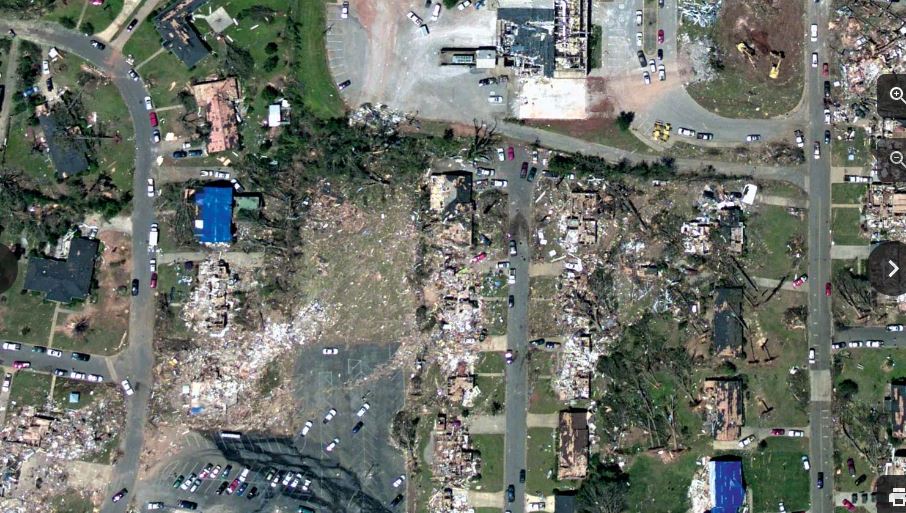
An aerial photo showing extensive damage from an Ef4 tornado that struck Tuscaloosa, Alabama, on April 27, 2011. NWS.
The NWS determined the path length of this violent tornado to be 80.7 miles with a maximum damage path width of 1.5 miles . The tornado’s most intense damage indicated peak winds of around 190 mph. It was given a final rating of EF4. Reports from Tuscaloosa indicated 44 people were killed, with an additional 20 deaths in Birmingham.
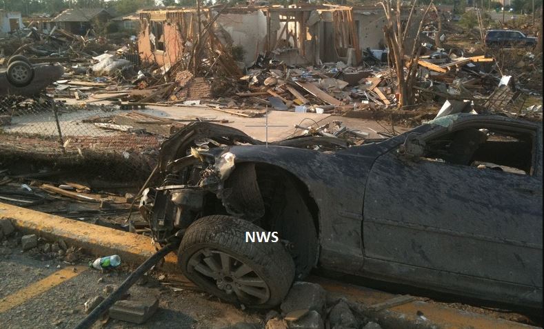
An NWS photo showing damage from an EF4 tornado that struck between Tuscaloosa and Birmingham, Alabama. on April 27, 2011.
A strong and long-tracked EF3 wedge tornado touched down in extreme southwest Greene County to the west-southwest of Tishabee at 5:30 p.m. CDT (22:30 UTC) and moved northeast. After having touched down in a rural area on the east side of the Tombigbee Rive, the tornado quickly intensified to high-end EF2 strength along County Road 69. Moving northeast, the tornado damaged a barn and de There were six fatalities and forty more were injured.
The tornado was rated as an EF3, with maximum sustained winds of 145 mph . It remained on the ground for almost an hour and a half, traversing over 72 miles . All told seven people were killed and at least 52 others were injured.
Georgia/Tennessee
A violent multiple-vortex tornado struck portions of extreme northern Georgia and southeast Tennessee during the mid-evening of April 27. It touched down along Davis Ridge Road in Catoosa County, Georgia, and moved through the town of Ringgold as an EF3 , destroying numerous homes and businesses. A motel located near Interstate 75 was partially destroyed by the tornado, along with a McDonalds, Taco Bell and several gas stations located on Highway 151 in Ringgold at Exit 348.
The Catoosa County Department of Family and Children Services and other businesses on Nashville Street in downtown Ringgold were also heavily damaged. The Kellerhals Center for Visual Arts Education at Ringgold High School was destroyed (RHS itself had minor damage), and Ringgold Middle School was heavily damaged. Past downtown Ringgold, the tornado reached EF4 intensity as it tore through a subdivision along Cherokee Valley Road at the north edge of town. Twelve homes were completely obliterated and swept away at that location.
There were 74 destroyed homes and businesses, 60 with major damage, and 118 with minor damage for a total of 252 affected structures in the Ringgold area. Eight people were killed, mainly at the subdivision along Cherokee Valley Road.
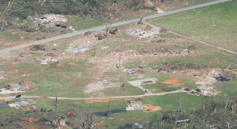
An NWS photo showing damage from an EF3 tornado (soon to be EF4) that struck Ringgold, Georgia,. on April 27, 2011.
The storm then crossed the Tennessee state line at 8:28 p.m. EDT. striking the small town of Apison at high-end EF4 strength, where large homes were leveled or swept away, 150 others were damaged, and thousands of trees were snapped and uprooted. The tornado then crossed into Bradly County at low-end EF4 strength, moving across the southern and eastern fringes of Cleveland and affecting mainly residential areas.
The tornado killed 20 people and injured hundreds more along its 48-mile (77 km) path across Catoosa, Hamilton, Bradley, Polk, and McMinn counties. The tornado was given a rating of EF4 with peak wind speed of 190 mph.
All roads in and out of Ringgold were closed until the morning of April 29; after roads leading to the affected areas were re-opened, residents and business owners were allowed to return.
Other Impacts
The storm storm system prolonged an ongoing heavy rain event, which began across Arkansas and Missouri. Weekly rainfall totals reached 19.73 inches 6 miles-northeast of Springdale, Arkansas 16.20 inches 4 miles northwest of Poplar Bluff, Missouri and 14.96 inches) at Westville, Oklahoma.
Farther south, flash flooding late on April 26 resulted in two fatalities in Monroe, Louisiana, after an apartment complex was swamped.
On April 25, 2011, thunderstorms with high winds swept through parts of southern and southeastern Ohio. Straight-line winds estimated at 80 miles per hour uprooted trees, damaged roofs, and downed power lines through Perry and Athens County in Ohio.. Strong thunderstorms and heavy downpours which led to flooding were also reported in areas across Upstate New York with heavy flooding in the Syracuse area. Severe thunderstorms were reported as far north as Northern Ontario on the evening of April 26.
Storms damaged the Tennessee Valley Authority power grid for transmitting electricity throughout the region. More than 300 power transmission towers, 120 to 150 feet (37 to 46 m) tall, were destroyed in the storms, some “twisted like bow ties” according to NWS meteorologist Eric Holweg. The towers supported some 90 transmission lines, a mixture of 500kV and 161kV lines. Those lines provided power from TVA to 128 regional distributors.
Hopefully, a tornado outbreaks like this on will extremely rare.

