

For residents of the Northeast, April is the proverbial “box of chocolates” when it comes to weather. Winter has a habit of overstaying its welcome. It’s difficult to prepare for all kinds of conditions. It can be 70 degrees one day and 28 degrees with snow the next. As I write this, many locations in the Northeast are recovering from a frigid morning with Saranac Lake, New York, recording a low temperature of three degrees BELOW zero and several locations in the region saw snow showers. !
All of this is unsettling to many but there was one VERY late winter weather event that is still talked about today.
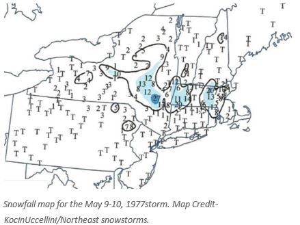
In May of 1977, a surprising snowstorm occurred across parts of the Northeast. Before it was all over, one to two feet of snow blanketed some higher elevations. The snow was accompanied by high winds. Extensive tree and power line damage kept crews working for days to restore power.
A Rare Event
Snow is not unheard of in May over parts of the Northeast, but many residents will refer to the “Mother’s Day” event in 1977 when asked about late season snow.. Actually, Mother’s Day (May 8th) was chilly with rain across much of the region. That night and into the next day, some dramatic changes were occurring in the upper atmosphere which would usher in cold air and change the rain to snow.
From parts of the Mid-Atlantic through Upstate New York and into New England, the landscape became whitened with snow by Monday morning, May 9th and the following night. The last flake didn’t stop falling until early on the 10th.
Heavy wet snow was accompanied by fierce winds across parts of New England. Massachusetts was particularly hard hit. There were blizzard conditions at times in eastern Massachusetts. Wind gusts reached 55 mph.
Boston only picked up .50 inches of snow but that set a record for their latest measurable snowfall.
Foxboro, Massachusetts recorded up 10 inches and 7 inches fell down to Providence, Rhode Island. For Providence, it was their only measurable snowfall in the 20th century. Heavier amounts of snow fell west of Boston with Worcester picking up 12.7 inches from the event.
One driver gave this description on a message board from www.americanwx.com about the storm :
I was out driving around the communities between 128 and 495.. Lincoln, Sudbury, Concord…
It was absolutely crazy. Tree branches were crashing down, roads blocked, no plows out… I called my boss and said, “I need to come in the driving is dangerous out here”. He acted like I was crazy. I told him we had 8 inches of snow on the ground and it was snowing heavily.
Here is another account:
We lived in Lexington at the time and lost many tree branches. My Dad was at a meeting at my school that evening, a mile and a half away from home, and couldn’t get home for more than a day because all the roads were blocked. He had to stay with friends that night.
Farther west, the Berkshires of Massachusetts picked up 10-20 inches of snow. 500,000 customers were without power across Massachusetts alone. Extensive power outages also extended westward into eastern New York and down into Connecticut.
In New York, a foot of snow fell in higher elevations west of Albany and 5 inches fell in the Glen Falls area. Parts of the Mohawk Valley saw 2 to 3 inches of snow. A couple of locations in the Finger Lakes region picked up 4 inches of snow. One location in the Catskill Mountains reported a whopping 27 inches of snow.
 Crews attempt to restore power in western Massachusetts while snow is falling on May 9, 1977. Credit-WMEC.
The higher elevations of northern Connecticut picked up over a foot of snow. Hartford recorded 1.5 inches.
 A photo of snow on the ground at Tolland, Connecticut, on May 9, 1977. Photo Credit – Public Domain.
Only a trace of snow fell around New York City but that was the latest snowfall on record. Trace amounts fell over New Jersey and much of Pennsylvania. Thunderstorms in southern Pennsylvania were accompanied by 70 mph winds.
The only good thing about the storm was that temperatures in the lower elevations were above freezing and with the higher sun angle, most of the roads didn’t become snow covered or icy.
Meteorological Conditions
On May 8th there were two areas of low pressure that were moving eastward. The first one was sliding across southern Ontario while the other was pushing into southern Pennsylvania. These systems were responsible for chilly temperatures and areas of rain.
Around the East Coast, there was a deep trough of low pressure developing. At the surface, the Pennsylvania low became the one dominant low around coastal New England, with, with a deep upper-level trough aloft. Cold air flowed down into the Northeast region from Canada. There was also some very cold air aloft that was manufactured by the upper trough.
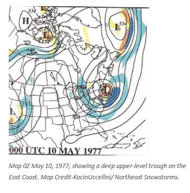 As temperatures fell on May 9th, the rain changed to snow in many locations. Due to the time of year, it was mainly an “elevation” snow event, but parts of southeast New England was proximate to the upper-level trough so significant snow fell at the lower elevations as well as cold air was brought down from aloft.
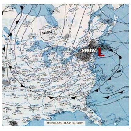 A surface weather map for May 9, 1977, shows a strong low-pressure system along the East Coast and associated precipitation. Map Credit- NOAA Central Library (Daily Weather Maps).
With leaves on the trees and heavy wet snow falling all you had to do was add significant wind to create havoc with trees falling on power lines all over.
Even though the main snow event was on Monday, May 9th, this event is still referred to as the “Mother’s Day Snowstorm” and it’s usually the one first that is mentioned when the topic of May snow comes up in the affected areas.

