

UPDATED 03/05/26 9:54 AM
Waves of rainfall will be a threat through tomorrow morning. Spring fever will be on display by next week with well-above-normal temperatures.
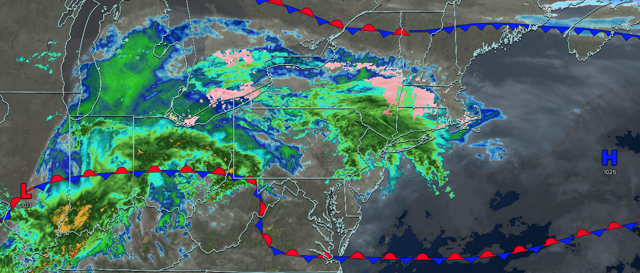
TODAY
Waves of low pressure will produce periods of rain. Winds will be from the east at 1 to 5 mph. High temperatures will range from the lower to mid-40s over the interior and New York City metropolitan area and upper 40s to lower 50s in the Philadelphia metropolitan area.
TONIGHT
An area of low pressure will pass through the region with periods of rain for most of the region. Areas of freezing rain will be a threat for the higher elevations in the Poconos, Catskills, and northern Connecticut. Winds will be from the northeast at 5 to 10 mph. Low temperatures will range from the lower to mid-30s over the interior and mid to upper 30s along the coast.
TOMORROW
The area of low pressure will exit the region with periods of rain in the morning. Skies will clear in the afternoon. Winds will be from the northeast at 5 to 10 mph. High temperatures will range from the mid to upper 40s over the interior, upper 40s to lower 50s in the New York City metropolitan area, and mid-50s to lower 60s in the Philadelphia metropolitan area.
TOMORROW NIGHT
A trough will pass through the region with scattered clouds and isolated showers. Winds will be from the northeast at 5 to 10 mph. Low temperatures will range from the mid to upper 30s.
SATURDAY
A trough will linger over the region with scattered clouds and isolated showers. Winds will be from the south at 5 to 10 mph. High temperatures will range from the lower to mid-50s over the interior and New York City metropolitan area, and from the upper 50s to the lower 60s in the Philadelphia metropolitan area.
SUNDAY
A cold front will produce widely scattered showers in the morning. Scattered clouds are expected in the afternoon. Winds will be from the west at 5 to 15 mph. Low temperatures will range from the mid to upper 40s over the interior, lower to mid-50s in the New York City metropolitan area, and mid to upper 50s in the Philadelphia metropolitan area. High temperatures will range from the mid to upper 50s over the interior and lower to mid-60s along the coast.
MONDAY
High pressure will produce scattered clouds. Low temperatures will range from the upper 30s to the lower 40s. High temperatures will range from the upper 50s to lower 60s on Long Island, mid to upper 60s over the interior and New York City metropolitan area, and upper 60s to lower 70s in the Philadelphia metropolitan area.
TUESDAY
High pressure will produce scattered clouds. Low temperatures will range from the lower to mid-40s. High temperatures will range from the lower 50s to lower 60s on Long Island and Connecticut, mid-60s to the lower 70s in the New York City metropolitan area, and lower to mid-70s over the interior and Philadelphia metropolitan area.
WEDNESDAY
High pressure will produce scattered clouds. Low temperatures will range from the lower to mid-50s. High temperatures will range from the mid-50s to mid-60s on Long Island and Connecticut, from the upper 60s to mid-70s in the New York City metropolitan area and interior, and from the upper 70s to lower 80s in the Philadelphia metropolitan area.
THURSDAY
A cold front will move through the region with scattered snow and rain showers. Low temperatures will range from the upper 20s to lower 30s for higher elevations, mid to upper 30s over the interior, and upper 30s to lower 40s along the coast. High temperatures will range from the lower to mid-30s for higher elevations, upper 30s to mid-40s over the interior, and upper 40s to mid-50s along the coast.


