

Boxing Day, celebrated on December 26th in the UK and Commonwealth countries, began as a day for the wealthy to give “Christmas Boxes” of gifts and money to their servants and the poor and a day of from work. On December 26th and 27th, 2010, a powerful Nor’easter dumped heavy snow (2-3 feet in New Jersey) and it produced hurricane-force winds and blizzard conditions across the Northeast (including New York City Philadelphia, and New England). Even though the U.S. doesn’t celebrate “Boxing Day” many residents and those in the media gave the storm this name. The storm, also known as the “December 2010 North American blizzard,” was a significant winter storm that created widespread disruption during the post-Christmas travel rush.
The storm was originally difficult to forecast a few days ahead. Meteorologist Steven DiMartino, owner and Chief Meteorologist for this website recalls the challenges.
“The Boxing Day Blizzard was a very difficult storm to forecast for. Even five days out, there was very little sign that a storm was going to be an issue around Christmas. However, by December 23rd, the trends in the observations clearly showed that the models were not capturing the storm threat correctly. With the ridge axis around Montana and strong enough blocking with a negative NAO, the shortwaves in the Arctic, Polar, and Subtropical jet streams were too close for comfort. I started watching the potential and warning clients/public of the potential on December 23rd with a You Tube video and discussions.
By Christmas eve, the ECMWF was the first model to catch on to the threat with the 12Z guidance. As Santa was visiting, the GFS and CMC followed as well. It was clear that a major winter storm was going to impact the New Jersey coast and New York City. The NWS issued Winter Storm Watches around 6 PM Christmas Eve. To make the forecast even more difficult, there was going to be a tight gradient from just a few snow showers in eastern Pennsylvania to several feet on the New Jersey coast. The forecast was difficult but an exciting challenge. The snow started on the morning of December 26th and and intensified through the day as the triple phase allowed for a powerful low pressure system along the East coast. By the way, watching the videos really took me back to where I began.”
Meteorological Conditions/Track
On December 22nd, an area of low pressure moved into California from the Pacific Ocean. The weather system weakened over the Rockies but it joined forces with a low pressure system than swung down from Canada from the northern polar jet stream and another disturbance that moved along the Gulf Coast along the subtropical jet stream. These players phased into one deep closed low pressure trough aloft .

Three upper-level disturbances combined to form one large trough in the eastern U.S. as seen on this NOAA satlelite image. Annotation Credit- Meteorologist Steven DiMartino.
The new storm received moisture and energy from the Gulf and then later, the Atlantic as it progressed eastward. The surface low moved up into the Florida Panhandle and Georgia before joining together with and upper-level trough to the north. The storm intensified rapidly near the coast of North Carolina and it then progressed rather slowly up the Eastern Seaboard.
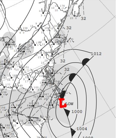

A surface weather map (left) and a 500 millibar upper level map (right) from December 2010. The maps show low pressure at the surface which is intensifying off the coast of North Carolina and the upper level chart shows a closed low pressure trough in the eastern U.S.
The storm reached its peak with with a central pressure of 960 millibars (similar pressure to a Category 3 hurricane). It then paraded up to Newfoundland and it produced damaging winds as it cut through the UK, Norway and eventually into Russia.
Impacts
The storm affected areas from the Middle Atlantic region to New England with heavy snow and damaging winds. Unlike many nor’easters, this one produced heavy snow all the way to the coast in places like New Jersey and Long Island! Twenty or more inches of snow extended northward from Washington, D.C. to New York City. Snowfall totals included 20 inches at Washington, D.C. The Philadelphia Eagles-Minnesota Vikings game was postponed due to safety concerns, Wilmington, Delaware reported nearly 2 feet of snow and a wind gust to 62 mph ! A State of Emergency was declared all the way down to North Carolina.
New Jersey
The Garden State was particularly hard hit. A State of Emergency was declared on December 26th. Major Interstates like I-78, and I-280 had closures and there were hundreds of accidents. Bus and rail line service was either partially or totally discontinued. Emergency vehicles were dispatched to aid stranded motorists. All other vehicles weren’t allowed on the roads.

A scene showing vehicles still stuck on a highway near Belmar, New Jersey, on December 29, 2010. Image Credit- Meteorologist Dan Zarrow.
Much of the state received over two feet of snow and parts of Ocean County picked up significantly more. Lightning ad thunder companied the snow in some locations ! Brick, picked up thee feet of snow with considerable bowing the drifting and zero visibility. Snow totals in other locations included 32,5 inches at Edison, 29 inches at Lyndhurst and 31.8 inches at Elizabeth!
Blizzard warnings were issued for eastern New Jersey where drifts reaches 7 feet high, where Cape May received 4 inches in just one hour! and Winter Storm Warnings were in effect to the west. On the night of December 26th, there were reports of snow plows getting stuck in the snow. Ambulances got stuck and some 911 dispatchers resorted to triage.
The snow caused Newark Liberty International Airport to close and Newark Mayor Cory Booker used Twitter to monitor the storm and post updated information to residents.

A photo showing a car buried in snow in Toms River, New Jersey, following the Boxing Day blizzard in 2010 which dumped 28 inches of snow in the community. Photo Credit-Carl Kouba.
New York
Central Park recorded 20 inches of snow. There were widespread transportation lockdowns city-wide. Most roads were impassable for days. Hundreds of busses became stuck in the snow and hundreds of passengers were stranded for many hours, All major airports in the area were shut down. Snow plows that were stuck in the snow were blocking other plows to get through. The process of snow removal was slow and tedious. Residents of Staten Island didn’t see a plow until New Year’s Day.

A photo of Broadway at 22nd Street in New York City taken on December after the “Boxing Day” blizzard. Photo Credit-Wikipedia-Public Domain.
There was plenty of finger pointing in political circles and that included NYC Mayor Bloomberg who had laid off hundreds of sanitation workers. Some workers, who were on duty didn’t plow on purpose as a protest. There was no Snow Emergency declared and streets were littered with stuck vehicles. Some blamed the National Weather Service for slow advance warnings.
There were two deaths including an elderly woman and a newborn baby.
A good portion of Long Island received up to to feet of snow with wind gusts over 60 mph causing considerable blowing and drifting The Long Island Railroad and most roads and arteries were closed or impassable. Snowfall totals included 24.7 inches at Islip, 23.5 inches at Medford and 23 inches at Smithtown.
Connecticut
Heavy snow and winds of up to 60 miles per hour caused a gas station roof to collapse in North Haven, and widespread tree damage and power outages throughout the state. Service on the Metro North New Haven Line and its branches was suspended on the 27th due to equipment and switch failures caused by the storm. Wilton recorded 18 inches of snow. North Canaan reported 16.1 inches, and 13.9 inches of snowfall was reported at Bradley International Airport, near Hartford.
Massachusetts
Coastal Massachusetts, along with coastal Maine, were hit hard with a recorded wind gust of 95 mph at Scituate. Logan Airport in Boston recorded 18 inches of snow. Cape Cod recorded gusts up to 80mph , causing major disruptions.
Maine
Sugarloaf ski resort derailed, causing several skiers to receive injuries after falling to the ground, sending seven to the hospital.
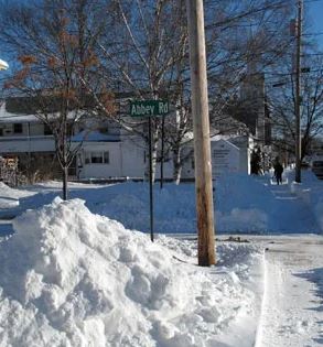
A photo taken in Brunswick, Maine, after the “Boxing Day” blizzard in 2010. Photo Credit-Jennifer Iacovelli.
The storm continues to move up through Atlantic Canada and into the North Atlantic.
Other Impacts
Hundreds of thousands lost power; over 750,000 in Connecticut, many in Massachusetts (60,000), New Jersey (8,000+), and New York (8,000+) with whole trees and tree branches falling on power lines due to the heavy weight of the snow. The death toll from the storm was 7 total. Storm damage was estimated to be 60 million 2010 dollars (about 90 million 2025 dollars).

