

The 2025-2026 winter season is off to a quick start with very cold temperatures across the Great Lakes and Northeast regions. Temperatures continue to be below average and there has been a significant amount of lake-effect snow.
This article will refer to an amazing lake-effect snow event that basted the city of Oswego, New York in December of 1958.
Before we proceed, for those not familiar with lake-effect snow, we’ll begin there. Lake-effect snow is more of a localized weather event which is a result of cold, dry air passing over a warmer body of water (like the Great Lakes).
The air picks up heat and moisture from the lakes. The air rises, cools and condenses to form clouds. Clouds form narrow bands and precipitation develops in the form of snow (if the air is cold enough) and there is a certain temperature difference between the lake temperature and the air mass temperature passing over it at about 5,000 feet. Heavy snow can extend well inland in narrow bands and the snowfall rate can reach 2 to 3 inches per hour (sometimes more) . Some lake-effect events have produced a total of 5 to 7 FEET of snow !
The orientation of these bands are guided by the prevailing wind flow a few thousand feet above the surface. The longer the fetch across the Great Lakes the more intense the band will be and the more snow will be produced. For example, notice (see image below) how Lake Erie is orientated front the southwest to the northeast so a southwesterly wind flow is favorable for Buffalo to receive heavy snow. As you will see below, Oswego’s favorable prevailing wind for heavy lake-effect snow is from the west.
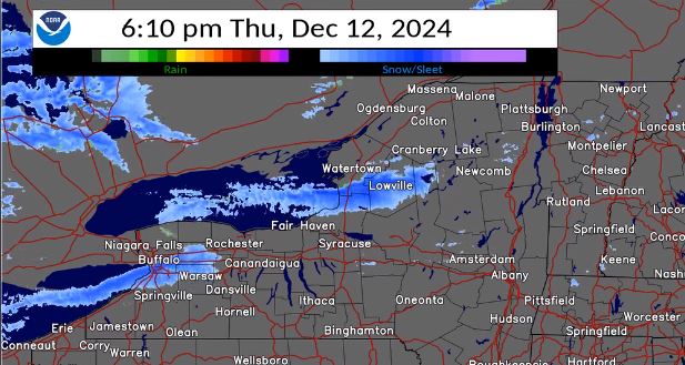
An NWS radar image showing bands of lake-effect snow extending eastward from Lakes Erie and Ontario on December 12, 2024.
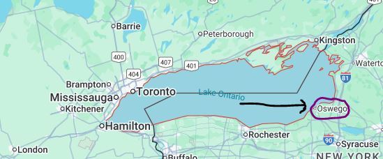
A map of Lake Ontario (city of Oswego circled). A westerly flow passing over a large portion of the lake is the most favorable for Oswego to receive heavy lake-effect snow. Map Credit-Google.
For the longest time, there wasn’t much written about lake-effect snow, let alone researched. A major localized snow event changed the narrative in December of 1958 when the Upstate New York city of Oswego, New York, was hit by a massive “snowburst” of 66 inches over a 5-day period !
Meteorological Conditions
It had been a very mild fall for the eastern Great Lakes area in 1958. December started with temperatures well above seasonal averages. All of that changed in a hurry, thanks to the upper-level atmospheric pattern. A trough of low pressure (dip in the jet stream) moved into southern Ontario and at the surface low pressure, with an attending cold front) swung through the region and up into Quebec. A westerly flow of very cold air moved in late on December 5th. Clouds developed and snow began to form.
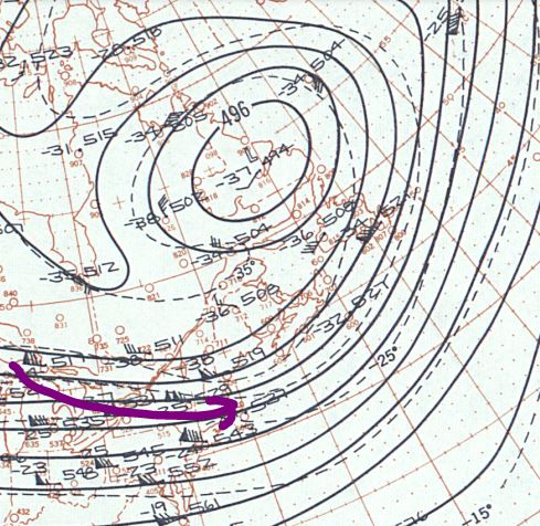
An upper-level cold low pressure trough in eastern Canada with a prevailing westerly wind flow across the eastern Great Lakes. Map Credit-NOAA – Daily Weather Maps.
On Saturday, December 6th, lake-effect snow began to fall in Oswego and in nearby Fulton, about 10 miles and to the south Mexico, New York , about 15 miles to the east. Both Oswego and Fulton picked up about 4 inches of snow that day. Over time, a lake-effect snow band intensified and it began to produce huge amounts of snow in a short period of time.
Impacts
On Monday, December 8th a NWS spotter reported a whopping 40 inches of snow. Schools were closed, including Oswego State Teachers College which eventually became SUNY at Oswego. Little did I know that twelve years later I would be a meteorology student at that institution ! There was no traffic and no deliveries. The Oswego Police Department began to deliver milk to residences.
The air temperature was quite cold during the event, most days saw the mercury hold in the teens but winds were light, so it didn’t qualify as a blizzard.
The snow ended on Thursday, December 11th. The final snow total for the event was 66 inches. As residents attempted to dig out, snow shovels became in short supply and the price for one increased dramatically.
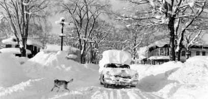
A dog moves away from a car covered with snow on street in Oswego, New York, in December 1958. Photo Credit – dryfly who dat (From Pinetrest).
Oswego Mayor Thomas O’Connor toured the city by sled, which was pulled by a team of Alaskan Huskies.
Aftermath
The snow ended on Thursday, December 7th and the residents had to deal with the 66 inches. As they attempted to dig out, snow shovels became in short supply and the price for one increased dramatically.
Oswego Mayor Thomas O’Connor toured the city by sled, which was pulled by a team of Alaskan Huskies.
Many residents and business owners were worried that the weight of the snow would cave in roofs and they were frantically shoveling from the rooftops.
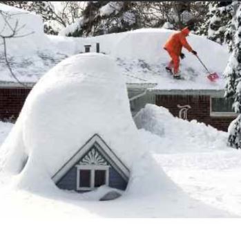
A man shovels the roof of his house in Oswego, New York after the “snowburst” event in December 1958. Photo Credit- From a Facebook post.
The event made national news and Time Magazine published a story about it and sent photographers there to add pictures to the story.
The overwhelming amount of snow inspired the late Dr. Maurice O. Boyd, who directed the Symphonic Choir at Oswego State, to pen “Oswego Is Famous For Its Snow.”
“Snowburst”
A Meteorology professor, Robert Sykes, came to Oswego a few years after his event but he did some research on it since he was extremely interested in the phenomenon of snow produced by the Great Lakes. He has often been referred to as the “grandfather” of lake-effect snow. He referred to the 40 inches of snow on December 8 during the 1958 event “Snowburst” and it became a common meteorological term to describe intense bursts of snow during lake-effect events ever since. I was extremely fortunate to have has Professor Sykes for two of my meteorology classes at Oswego State.
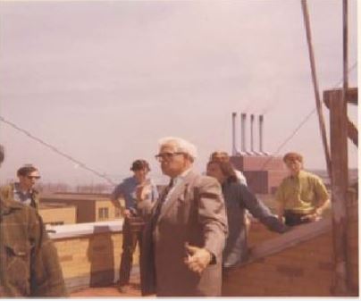 This photo of Professor Robert Sykes (taken by me) from the roof of Piez Hall as he talks to our Current Weather Patterns class at the (then) State University College at Oswego in April 1973.
1958 vs. 1966 Snow Events
Eight years after the 1958 snow, Oswego would be buried by a multi-day snow event that would result in a whopping 102 inches (as recorded by Professor Sykes). This event was accompanied by strong winds, which reaches blizzard criteria as opposed to 1958 when the winds were much lighter. The snowfall in 1966 event wasn’t totally a lake-effect situation whereas 1958 was all lake-effect snow. The blizzard of 1966 was a combination of snow from an East Coast storm, with snow enhanced by Lake Ontario, followed by lake-effect snow. Professor Sykes would refer to the 1966 and 1958 events quite often in our class.


