

A devastating blizzard struck the Great Lakes from November 7-10, 1913 with wind gusts to 90 mph and wave heights to 35 feet and blinding snow ! The storm, a resulting from the merger of two weather systems resulted in over 250 deaths and the loss of at least 12 ships. The storm became commonly known as the “Great Storm” or “The Great White Hurricane” !
Many of you might remember a vicious November storm that pounded parts of the Great Lakes region in 1975 and caused the sinking of the “Edmund Fitzgerald”. This storm was much stronger and widespread and it produced a crippling snow event in northern Ohio.
Recipe For A Disaster
The days leading up to this historic event were actually quite mild around the Great Lakes region. It all began on November 6th around Lake Superior.
At the time, there was a low-pressure system, with an arctic cold front “Alberta Clipper” moving across southern Canada toward the upper Great Lakes. Southerly winds increased on Lake Superior but temperatures were mild. By the morning of November 7th major changes were about to occur.
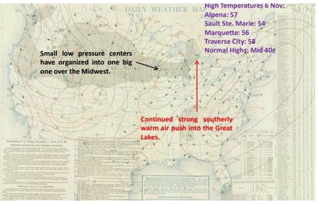
A surface weather Map valid 7 a.m. November 7th (annotated by the U.S. Weather Bureau) indicates mild temperatures ahead of the “Great Storm” of 1913. Map Credit-NOAA Central Library.
Behind the low-pressure system and arctic front, temperatures fell rapidly to the single digits across the Northern Great Plains. Strong northwesterly winds were felt behind the front. To the south, another area of low pressure was moving eastward from the southern Plains to North Carolina.
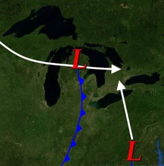
The “Great Storm” of 1913 was the result of two storm systems merging around the eastern Great Lakes. Map Credit-NWS.
Weather forecasting was primitive in those days, there were no computer models and weather forecasters had no way of knowing that an upper-level trough would deepen around the Great Lakes and the northern and southern storms would merge together as one incredibly intense low pressure system. They had no idea that winds would soon exceed hurricane-force, that wave heights would reach 35 feet on the Great Lakes or that Cleveland, Ohio, would receive nearly two feet of snow in a 24-hour period.
 Meteorological equipment was quite primitive in 1913. Image Credit-NOAA.
An Incredible Storm
On the morning of Friday, November 7th, Coast Guard Stations and the U.S. Weather Bureau along the Lake Superior ports raised white pennants above red flags (storm warnings). By the afternoon, those flags were replaced by a sequence of red and white lanterns (hurricane-force winds) expected. The cold front had already passed and winds were already above 50 mph as the rain turned rapidly to snow. Visibilities had been reduced to zero as blizzard conditions and became widespread in the upper Great Lakes.
On Saturday, November 8th, the storm had been upgraded to “severe” status. Low pressure was centered over eastern Lake Superior. A weather forecast from Port Huron indicated that southerly winds had remained “moderate to brisk”. Northwesterly winds had reached gale strength on northern Lake Michigan and western Lake Superior, as winds exceeded 60 mph at Duluth, Minnesota.
A brief lull in the storm allowed traffic to begin flowing again on the Great Lakes. Gale wind flags were raised at more than a hundred ports but were ignored by many ship captains. Ships traveled all that day through the St. Mary’s River right through the Straits of Mackinac and early Sunday morning up the Detroit and St. Clair Rivers.
On Sunday, it appeared that weather conditions would be improving as the cold front moved eastward and the barometric pressure began to rise. Winds were gale-force on Lake Huron but all seemed manageable. The U.S. Weather Bureau in the area sent the first of its two daily weather reports to Washington, D.C. There was nothing alarming in the report. The meteorologists had no way of knowing what would happen next.
Because of the atmospheric features that I mentioned earlier, the southern low-pressure system was beginning to gain strength as if moved northward past Virginia and Maryland and it began to curve a bit northwestward as it was influenced by the deepening upper-level trough over the Great Lakes.
This low was taking over as the main system and its pressure was falling very rapidly. As the morning progressed the low pressure was down to 29.10 inches (982 millibars). Meanwhile, the arctic cold front was sweeping across the Ohio Valley.
By evening, the storm’s central pressure had crashed down to 28.61 inches (969 millibars). An arctic high-pressure system was moving toward the Great Lakes from Canada with a pressure of 30.51 inches (1033 millibars). This immense pressure gradient was responsible for the intense northwest wind. On Lake Huron, wind gusts to at least 90 mph were reported, along with wave heights to an unbelievable 35 feet.
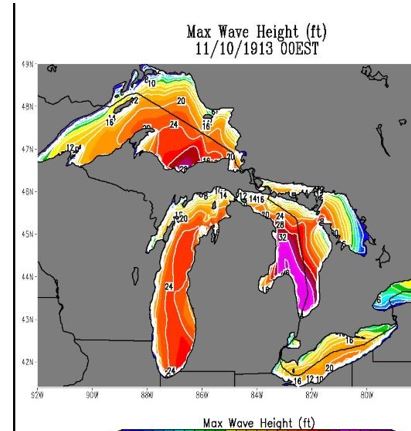
A computer simulation from November 9, 1913, indicates wave heights over 30 feet on Lake Huron. Image Credit-NOAA.
Heat and moisture were added by the Great Lakes and that was another factor in the overall strength of the storm. The interaction between the frigid air and the warmer waters of the Great Lakes produced very heavy lake-enhanced snow. Moist, Atlantic air wrapping into the low was another contributing factor. Strong winds covered the entire Great Lakes region and eastward to the St. Lawrence Valley.
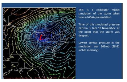
A NOAA recreation of the 1913 storm *”Great White Hurricane” is seen on this weather map. Map Credit-NOAA.
The storm slowly weakened on Monday as its center remained stationed over the eastern Great Lakes. It finally began to move eastward on Tuesday.
Impacts
For some areas, it was the very destructive wind that topped trees, telephone poles and power lines and for other areas, it was a combination of wind and snow. Persistent blizzard conditions crippled cities like Cleveland, Ohio, for days. The storm wreaked havoc on the Great Lakes where many ships were wrecked and many men aboard them lost their lives. Winds gusted to at least 90 mph (some mariners reported gusts closer to 100 mph). The lake water crashed over the ship’s decks and froze instantly. Visibilities down to zero with heavy snow made navigating these ships nearly impossible.
On Lake Superior, eight ships were run aground and smashed into rocks and two freighters sank to the bottom of the lake with all onboard killed. One freighter (Henry B. Smith) sank with 23 men aboard. The wreck was finally discovered in 2013.
A steamer (L.C. Waldo) ended up shattered against the rocks of Manitou Island on Lake Superior amidst monster waves. Before that occurred, The crew was rescued by the crew of another ship. There is a photo of the ship just after the crewmembers were rescued.
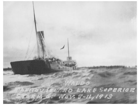
A photo of the L.C. Waldo shortly after its crew was rescued on Lake Superior during the “Great Storm” of November 1913. Photo Credit-Great Lakes Historical Society.
On Lake Huron, eight freighters were lost beneath the incredible waves in just four hours. One ship (Charles S. Price) over 500 feet long and a weight 6,000 tons was capsized and it floated upside down for many days until a diver could confirm its identity. Engineer Milton Smith, who decided not to travel with the crew on the premonition of impending disaster, was called to identify bodies swept ashore.
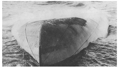
A photo of the Charles S. Price, upside down on the southern end of Lake Huron after the “Great Storm of November 1913.. Photo Credit-Wikipedia-Pubic Domain.
A NOAA report about this storm printed a firsthand account of the storm from the Lake Carriers Association –
“No lake master can recall in all his experience a storm of such unprecedented violence with such rapid changes in the direction of the wind and its gusts of such fearful speed! Storms ordinarily of that velocity do not last over four or five hours, but this storm raged for sixteen hours continuously at an average velocity of sixty miles per hour, with frequent spurts of seventy and over.
Obviously, with a wind of such a long duration, the seas that were made were such that the lakes are not ordinarily acquainted with. The testimony of masters is that the waves were at least 35 feet high and followed each other in quick succession, three waves ordinarily coming one right after the other.
They were considerably shorter than the waves that are formed by an ordinary gale. Being of such height and hurled with such force and such rapid succession, the ships must have been subjected to incredible punishment!”
Cities across northern Ohio encountered the fierce bitterly cold winds and heavy snow. On November 9th, winds were out of the northwest most of the day but they shifted to the west at speeds of over 50 mph with a peak gust of 79 mph. Cleveland picked up nearly two feet of (lake enhanced) snow from the storm and drifts were up to six feet high in the center of the city. Trees and telephone poles were down all over the city, Transportation was brought to a halt as streetcars were frozen in their tracks.
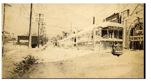
The photo shows a streetcar stranded in large snowdrift In Cleveland, Ohio, following the ‘Great White Hurricane” of November 1913. Photo Credit-Wikipedia-Public Domain.
Snowfall exceeding one foot was common over parts of northern Michigan, Detroit picked up about four inches, while Buffalo. New York, encountered periods of rain and snow with fierce winds.
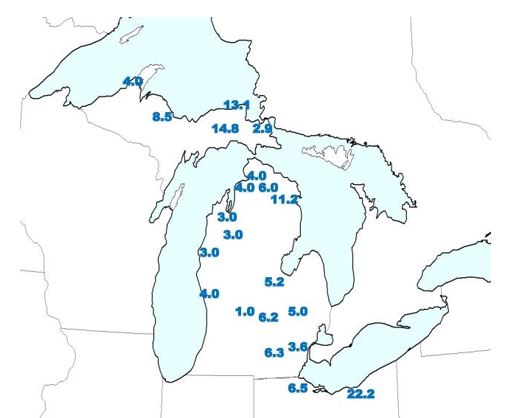
This map shows some snowfall totals (inches from the “Great White Hurricane” in November of 1913. Map Credit-NOAA.
Facts And Figures
The brunt of the storm was over a 4-day period. With primitive meteorological equipment and technology, there was no way to prepare for a storm of this force. The storm wrecked 19 ships on the Great Lakes and another 19 were badly damaged. Winds were constantly over 50 mph and there were many gusts well over hurricane-force.
This storm remains the deadliest and most destructive natural disaster to hit the Great Lakes in recorded history, The death toll was reported to be over 250 with most deaths occurring on the Great Lakes. An NOAA wave reconstruction computer simulation estimated that the highest waves were up to 35 feet. The overall damage estimate from the storm was around 5 million dollars (about 164 million dollars in 2025) !
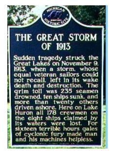 There are various markers on both the U.S. and Canadian sides of Lake Huron commemorating this event like the one above.

