

As we have seen this week, a very cold blast of air swept southward into parts of the U.S. with record cold and impressive lake-effect snow totals. These early season events do occur from time to time. In November of 2014 there was deep (cold) trough aloft across the eastern U.S. At the surface, low pressure was moving slowly across Ontario Canada.
The circulation around the low brought some very cold air over the warmer waters of the Great Lakes. Bands of lake-effect snow developed. Quite often these bands don’t hang around in one place very long with the wind flow disrupted by small weather systems (e.g. troughs). This tends to keep snowfall totals from getting out of hand. In November of 2014, however, a lake-effect event developed and with a surface trough hanging well back into Michigan, the snow band from Lake Erie stayed in place for a long period of time. The result was an incredible snow event in the Buffalo, New York, area that was one for the ages !

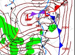
Map 1 ( above left) shows a deep (cold) trough in the upper levels of the atmosphere on November 18, 2014.
Map 2 (above right) shows low pressure over Canada which directed very cold air over the Great Lakes on November 18 ,2014, Note the surface trough well back in Michigan do the directional wind flow and resultant intense snow band from lake Erie remained stationary for long periods of time.
Many parts of the Buffalo, New York area picked up 5 to 7 FEET of snow, while some areas north of Buffalo only received a couple of inches. East Aurora, southeast of Buffalo, received an incredible 88 inches ! The event was given the name “Snovember” by many and the name stuck.
Unfortunately, Fourteen people died in this event and there wee widespread roof collapses from the weight of the heavy snow and trees falling on roofs. Thousands of motorists were stranded, many on the New York State Thruway as a 100-mile stretch was closed.
Lake-Effect Snow – November 17-19 2014
The event began on Monday, November 17th as a band of lake-effect snow developed over the Buffalo Southtowns and then moved up to the Northtowns. The significant difference between very cold air mass over a much warmer Lake Erie produced extreme atmospheric instability so there was lightning and thunder with the snow. However, by 9PM the snow had moved mostly just south of the city and airport and locked in place as the 15-20 mile wide band centered on a line from Lackawanna and Hamburg ENE across West Seneca, Lancaster, and Alden.
The northern edge of the lake effect band was so striking that many described it as a “wall of snow”. Snowfall rates on the northern edge easily exceeded 3 inches per hour with some snowfall rates near 6 inches per hour! By sunrise some areas had already exceeded 3 feet of snow. This occurred in under 12 hours.
Meanwhile, the southern edge of the band was located along the Lake Erie shoreline in Chautauqua County to near the Southtowns, including Orchard Park, East Aurora, and east into Wyoming county, including Attica, where about a foot of snow had fallen by sunrise. Travel across the Southtowns was nearly impossible with most roads unplowed. Plows, those that weren’t stuck, focused on a few main roadways needed for emergency vehicles. The NYS Thruway was was shut down from the PA border to Rochester, and other routes, including 190, 290, and 400 were also closed.
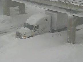
This truck was one of hundreds of vehicles stranded on the New York State Thruway on November 18, 2014 outside of Buffalo, New York on November 18,2014.
On Tuesday, November 18th, the Lake Erie snow band remained in place. Some areas east and southeast of Buffalo picked up over 4 to 5 feet of snow ! Amazingly, areas from Downtown Buffalo on northward saw sunny skies while just a few miles south there south the visibility down to zero for a long period of time with snowfall rates of at least 3 inches per hour. Residents were stuck in their homes as there was no way to get out since the streets were buried in snow !
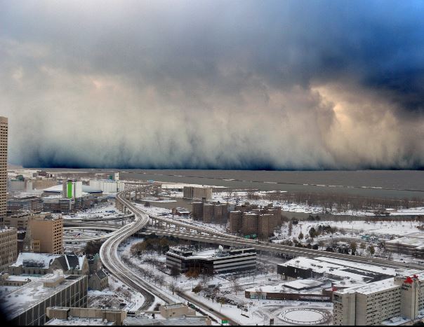
This amazing photo is looking southward from downtown Buffalo, New York on November 17, 2014. Note the blue skies over downtown looking at a “wall of (lake-effect) snow” . Photo Credit – Wikipedia – Public Domain.
On Tuesday night the snow band weakened a bit and it vacillated a little north and south around the Southtowns. On Wednesday morning a weakened band moved northward through Buffalo.
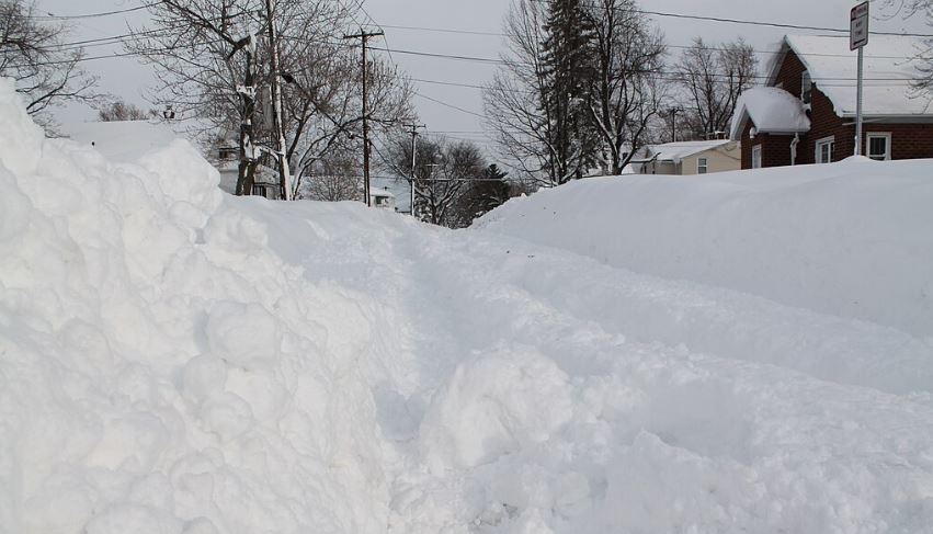
This photo was taken in West Seneca, New York, on November 19, 2014 after nearly 80 inches of lake-effect snow buried the town. Photo Credit- Staxeon-Wikipedia Commons.
Impacts
Fourteen people perished in the event, most of them were from heart attacks or exposure to the elements. Hundreds of homes and buildings suffered structural collapses by the pure weight of the snow. Thousands of people were stranded on streets, roads and highways for several days. There were critical shortages of gasoline and food. Volunteers created caravans with shovels who had the tedious task of opening streets and sidewalks in the Buffalo area.
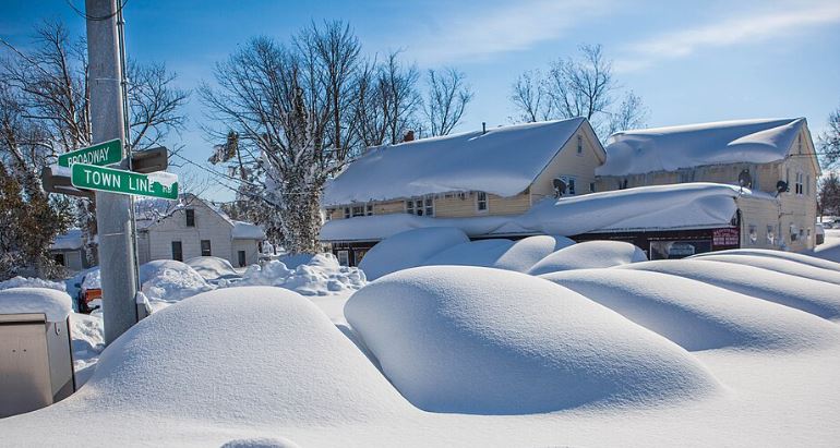
This photo is from the village of Town Line, New York (east of Buffalo) , on November 19, 2014 after several feet of snow blocked streets and buried cars.. Photo Credit-Wikimedia Commons – Public Domain.
A scheduled NFL football game between the Buffalo Bills and the Detroit Lions was moved from Buffalo to Detroit. Many Bills fans crossed over the Peace Bridge into Canada, then westward on Highway 3 (which runs north of Lake Erie) to get to Detroit in order to see the game.
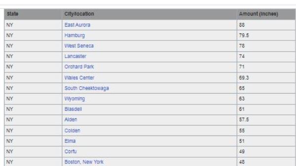
The chart below shows some snowfall totals around the Buffalo area from this event (info from NWS-Buffalo).
Several counties in western New York were under a state of emergency, which was declared by Governor Andrew Cuomo.
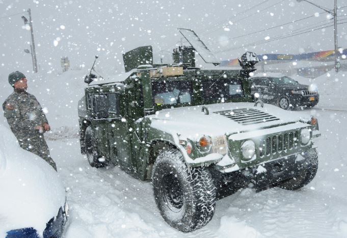
The National Guard was sent to the affected areas to assist with rescue and recovery (see photo above) from the U.S. DoD !
.

