

Nor’easters, some with heavy snow, aren’t uncommon for residents of the Northeast U.S. They are expected during the winter months but in 2011 there was an October surprise and heavy snow and power outages disrupted Halloween activities for many residents.
A nor’easter is a storm system along the East Coast of the U.S. that results in significant northeast winds and heavy precipitation in the form of snow or rain. These storms are named for the direction of their winds and can bring heavy rain, snow, high winds, and coastal flooding, often lasting for several days.
October 2011 Meteorological Conditions
A nor’easter impacted the Mid-Atlantic and Northeast from October 29-30, 2011, bringing heavy, wet snow to areas from Pennsylvania to Maine and over 30 inches to parts of Massachusetts and New Hampshire. The storm was caused by a strong upper-level trough and a surface low that developed off the Carolinas and moved up the coast. It caused widespread power outages affecting millions due to the heavy, wet snow on trees that still had leaves on them.
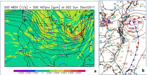
This map shows 500mb (upper-level) trough over the eastern US and a surface low pressure off the East Coast on October 29th, 2011. Map Credit – NOAA.
Precipitation began falling across the Mid-Atlantic States on the morning of October 29th. Initially, the precipitation was falling as snow only at the higher elevations . As the surface low moved northward up the coast, winds at the surface backed from northeasterly to northwesterly across much of the Mid-Atlantic region, allowing colder air to push southeastward. This cold air changed the precipitation from rain to snow in the foothills of Virginia, Maryland, and Pennsylvania. Dynamic cooling, where rising air associated with heavy precipitation resulted in atmospheric cooling and the rain changed to snow from rain to snow across the rest of Mid-Atlantic region.

This image shows snow falling with leaves still on the trees in Alden, New York, during the “Halloween Nor’easter in 2011. Image Credit – Daniel Case.
To the north, precipitation began across New England by midday on October 29th. Cold air was already in place across interior New England, so precipitation began as snow for all but the coastal areas. The heaviest snow fell in a band from eastern Pennsylvania and northern New Jersey northeastward to southern New Hampshire and Maine. The snow accumulated quickly in the higher elevations.

A photo showing bent trees with heavy wet snow weighing them down blocking a road near Granby, Connecticut, resulting from the “Halloween Nor’easter” of 2011. Photo Credit – Dave Ginsberg.
Snowfall Totals (from NWS/Wikipedia)
- Peru, Massachusetts: 32.0 inches
- Jaffrey, New Hampshire: 31.4 inches
- Plainfield, Massachusetts: 30.8 inches
- Action, Maine: 20.0 inches
- West Milford, New Jersey: 19.0 inches (October record) !
Notable Totals By State
- Connecticut: 18.6 inches in Bakersville and 18.0 inches in Winsted
- Maryland: 11.6 inches in Frostburg and 11.5 inches in Sabillasville
- New York: 21.6 inches in Millbrook and 17.7 inches in Bloomingburg
- Pennsylvania: 16.0 inches in Hazleton and Huffs Church
- Vermont: 16.0 inches in West Halifax
- Virginia: 9.0 inches in Skyland and 8.0 inches in Big Meadows
New York City (Manhattan) recorded 2.9 inches of snow where an “Occupy Wall Stree”t demonstration was taking place.
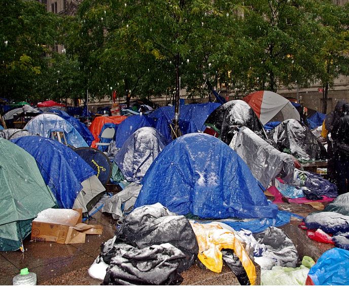 A photo showing snow falling on “Occupy Wall Street” demonstrators in Manhattan, New York. Photo Credit- Wikipedia – Pubic Domain.
Impacts
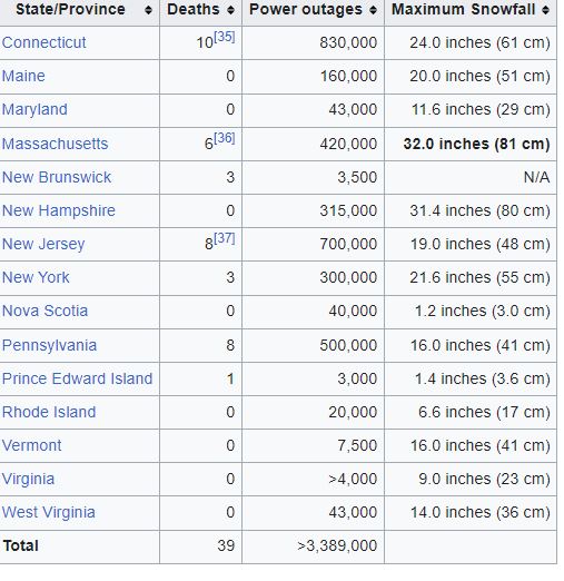
The weight of the snow on trees still full of leaves caused widespread damage to power lines, resulting in over 3.3 million customers losing power in the Northeast region. Connecticut Governor Dannel Malloy said the state experienced the largest number of power outages in its history. Most cities in the state opened centers where chilled residents could stay warm. In addition, wind gusts along the coast exceeded 50 mph, with a maximum gust of 69 mph recorded at Nantucket, MA.
The storm resulted in 39 deaths, both directly and indirectly. A few of the deaths occurred when people froze to death in their homes, others occurred due to carbon monoxide poisoning as people attempted to heat their homes by alternative means. Air travel was severely disrupted. This included several planes that were stranded on the tarmac at the Hartford airport for up to seven hours.
Specific statistics (by state) can be seen in the chart below … From Wikipedia

This photo was taken at a post Halloween event that was originally postponed during the “Halloween Nor’easter” in 2011 in Pequannock, New Jersey . Photo Credit – Christopher Lotito.
Odds And Ends
This storm was referred to by several names. because it was so close to Halloween and it disrupted many Halloween activities in local area it was called the “Halloween Nor’easter”. Others name for it across the media were “Shocktober”, and “Octoberblast”.
I was at The Weather Channel then and we anticipated ahead of time it and sent a live crew up to New England to report on it. We called it and branded on our live reports as “Snowtober.” Sice The Weather Channel had begun to name winter storms alphabetically, This one, the first winter storm of the season was “Alfred”.
Southern New England had just emerged very wet late summer with record rainfall thanks in part to Tropical Storm Irene, and Tropical Storm Lee. Wet weather and above-normal temperatures seemed to delayed the fall foliage. The leaf colors were rather dull and many leaves didn’t even fall off the trees. These factors were all set to create a major disaster for the region.
As I write this (pre-Halloween 2025) there is a storm system just off the coast of New Jersey . This coastal storm is creating disruptions of its own with heavy rain, strong winds gusts and flooding, but no snow !


