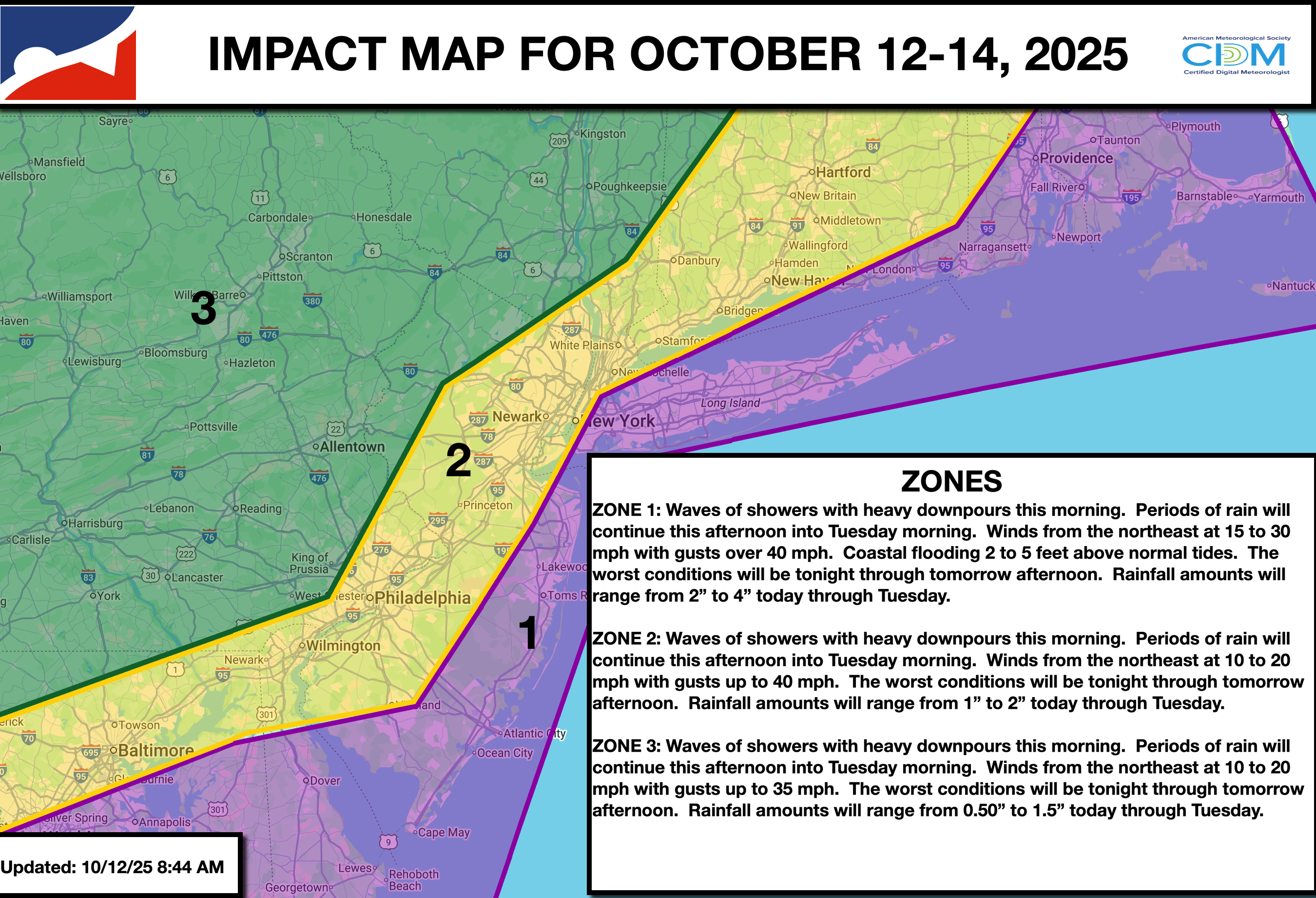
A complicated coastal storm will invade the region today with periods of rain, strong winds, and coastal flooding.
TODAY
An area of low pressure will produce waves of showers capable of heavy downpours. Winds will be from the northeast at 10 to 20 mph with gusts up to 40 mph away from the coast and 15 to 30 mph with gusts over 50 mph along the coast. High temperatures will range from the upper 50s to the lower 60s. Coastal flooding will be a threat.
TONIGHT
An area of low pressure will produce waves of rainfall, heavy at times. Winds will be from the northeast at 10 to 20 mph with gusts over 30 mph away from the coast and 15 to 30 mph with gusts over 40 mph along the coast. Low temperatures will range from the upper 40s to the lower 50s over the interior and from the lower to mid-50s along the coast. Coastal flooding will be a threat.
TOMORROW
An area of low pressure will produce waves of rainfall, heavy at times. Winds will be from the northeast at 10 to 20 mph with gusts over 30 mph away from the coast and 15 to 30 mph with gusts over 40 mph along the coast. High temperatures will range from the upper 50s to the lower 60s. Coastal flooding will be a threat.
TOMORROW NIGHT
An area of low pressure will exit the region with scattered showers. Winds will veer from the northeast to the north at 5 to 15 mph. Low temperatures will range from the upper 40s to the lower 50s over the interior and from the mid to upper 50s along the coast.
TUESDAY
An area of low pressure will exit the region with scattered showers. Skies will clear in the late afternoon and evening. Winds will be from the north at 5 to 15 mph. High temperatures will range from the upper 50s to the lower 60s.
WEDNESDAY
High pressure will give way to a cold front in the evening with scattered clouds. Winds will be from the northwest at 5 to 15 mph. Low temperatures will range from the lower to mid-40s over the interior, upper 40s to the lower 50s in the suburbs, and mid-50s in urban areas. High temperatures will range from the mid to upper 60s over the interior, from the upper 60s to the lower 70s along the I-95 corridor, and from the mid to upper 60s along the coast.
THURSDAY
High pressure will produce scattered clouds. Low temperatures will range from the upper 30s to the lower 40s over the interior and from the mid to upper 40s along the coast. High temperatures will range from the upper 40s to lower 50s over the interior and mid to upper 50s along the coast.
FRIDAY
High pressure will produce scattered clouds. Low temperatures will range from the mid to upper 30s over the interior, upper 30s to lower 40s in the suburbs, and lower to mid-40s in urban areas. High temperatures will range from the mid to upper 50s over the interior and from the upper 50s to the lower 60s along the coast.
SATURDAY
High pressure will produce scattered clouds. Low temperatures will range from the lower to mid-30s over the interior, upper 30s to the lower 40s in the suburbs, and lower to mid-40s in urban areas. High temperatures will range from the mid to upper 50s over the interior, upper 50s to the lower 60s along the I-95 corridor, and mid to upper 50s along the coast.
SUNDAY
High pressure will produce scattered clouds. Low temperatures will range from the mid to upper 50s. High temperatures will range from the mid to upper 60s on Long Island, upper 60s to lower 70s along the coast, and mid to upper 70s away from the coast.