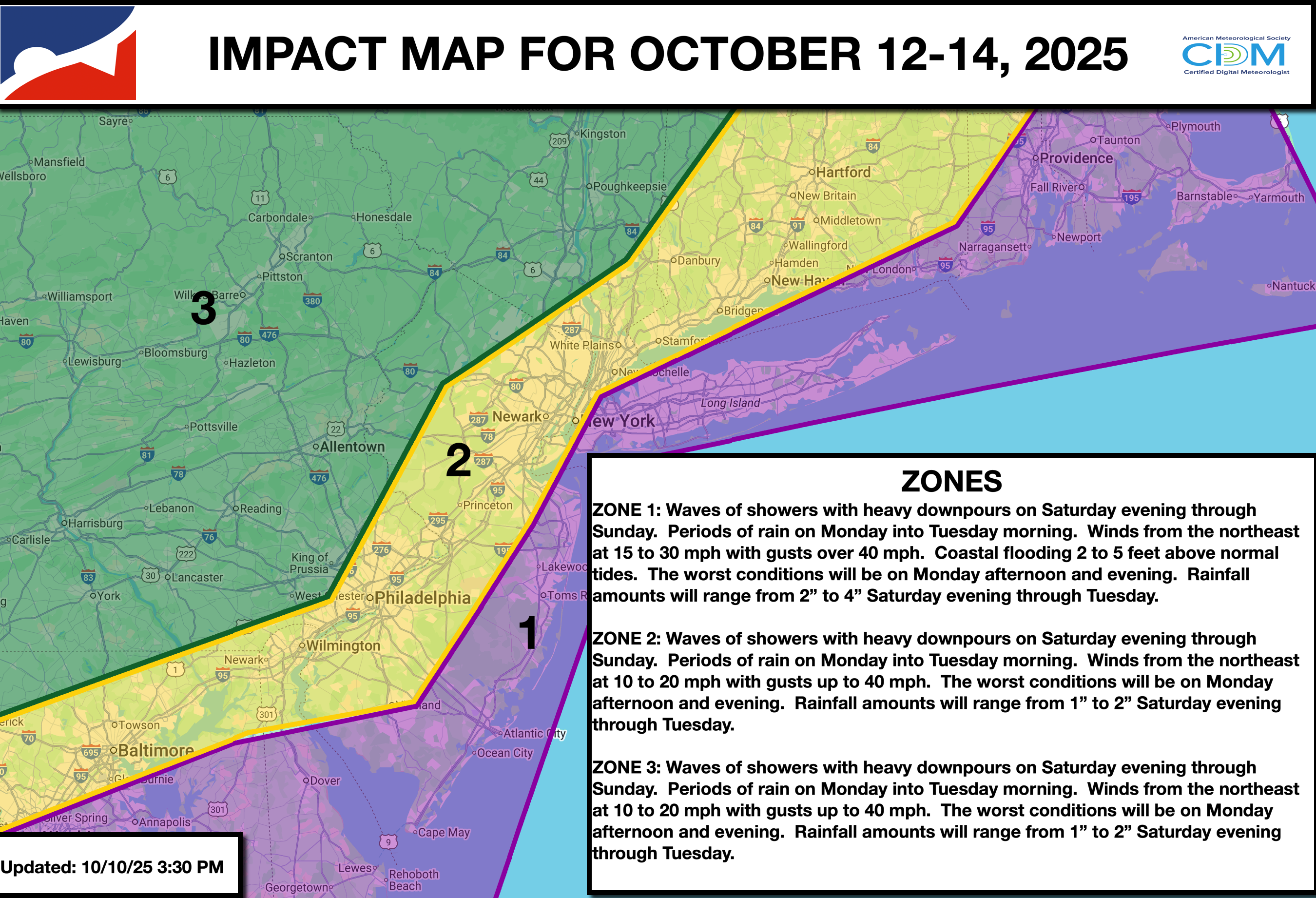
Excellent Fall weather conditions will continue through this evening. A dangerous coastal storm will begin to impact the region this Sunday and linger into Tuesday. Heavy rain, urban flooding, coastal flooding, wind damage, and power outages are threats.
TONIGHT
High pressure will exit the region with increasing clouds. Winds will back to the southeast at 1 to 5 mph. Low temperatures will range from the lower to mid-40s over the interior, upper 40s to lower 50s in the suburbs, and mid to upper 50s in urban areas.
TOMORROW
An area of low pressure will develop to the south, bringing increasing clouds and widely scattered showers. Winds will be from the east at 5 to 15 mph. High temperatures will range from the lower to mid-60s over the interior, upper 60s to the lower 70s along the I-95 corridor, and mid to upper 60s along the coast.
TOMORROW NIGHT
An area of low pressure will approach the region with overcast skies and scattered showers capable of heavy downpours. Winds will be from the east at 5 to 15 mph. Low temperatures will range from the lower to mid-50s over the interior, upper 50s to lower 60s in the suburbs, and lower 60s in urban areas.
SUNDAY
An area of low pressure will produce waves of scattered showers capable of heavy downpours. Winds will be from the northeast at 10 to 20 mph with gusts up to 40 mph away from the coast and 15 to 30 mph with gusts over 50 mph along the coast. High temperatures will range from the lower to mid-60s over the interior, upper 60s to lower 70s along the I-95 corridor, and mid to upper 60s along the coast. Coastal flooding will be a threat.
MONDAY
An area of low pressure will produce waves of rainfall, heavy at times. Winds will be from the northeast at 10 to 20 mph with gusts over 30 mph away from the coast and 15 to 30 mph with gusts over 40 mph along the coast. Low temperatures will range from the upper 40s to the lower 50s over the interior and from the lower to mid-50s along the coast. High temperatures will range from the upper 50s to the lower 60s. Coastal flooding will be a threat.
TUESDAY
An area of low pressure will exit the region with scattered showers. Windy conditions will continue. Low temperatures will range from the upper 40s to the lower 50s over the interior and from the mid to upper 50s along the coast. High temperatures will range from the upper 50s to the lower 60s.
WEDNESDAY
High pressure will give way to a cold front in the evening with scattered clouds. Low temperatures will range from the lower to mid-40s over the interior, upper 40s to the lower 50s in the suburbs, and mid-50s in urban areas. High temperatures will range from the mid to upper 60s over the interior, from the upper 60s to the lower 70s along the I-95 corridor, and from the mid to upper 60s along the coast.
THURSDAY
High pressure will produce scattered clouds. Low temperatures will range from the upper 30s to the lower 40s over the interior and from the mid to upper 40s along the coast. High temperatures will range from the upper 40s to lower 50s over the interior and mid to upper 50s along the coast.
FRIDAY
High pressure will produce scattered clouds. Low temperatures will range from the mid to upper 30s over the interior, upper 30s to lower 40s in the suburbs, and lower to mid-40s in urban areas. High temperatures will range from the mid to upper 50s over the interior and from the upper 50s to the lower 60s along the coast.