

One fact that we need to know about hurricanes is that the size (diameter) doesn’t always correlate to how strong it is. In August of 2004 there was a rather small hurricane that inflicted billions of dollars damage across parts of the Florida Peninsula. The death toll was reported to be fifteen.
After its humble beginnings as an innocuous tropical wave off the African Coast on August 4th, 2004, little did residents of Florida know that a very unique and devastating hurricane would strike them nine days later. Charley gave forecasters fits in the hours leading up to U.S. landfall and it changed the way that information about tropical systems was communicated to the public.
Innocuous Beginnings
Twenty one years ago, On August 4, 2004, a tropical wave, as they often do, moved out into the eastern Atlantic from the coast of Africa. The wave moved at a pretty good pace to the west and slowly began to organize.
It moved to the Lesser Antilles and it became a Tropical Depression (Number 3) near the island of Grenada on August 9th. The depression was one of the few that managed to gain strength in the eastern Caribbean. On August 10th it was named Tropical Storm Charley.
While Charley was approaching Cuba on August 12th, a strengthening high-pressure ridge aloft. changed the track of the tropical storm and it began to move to the west-northwest.
A Wild Ride
Charley became a hurricane with maximum sustained winds of 75 mph just south of Kingston, Jamaica. One person died and one million dollars of property damage, along with extensive agricultural damage, was recorded from Charley on August 11th and 12th.
After departing Jamaica, Charley became a Category 2 hurricane as it turned to the northwest toward Cuba. Charlie intensified to a major hurricane (Category 3) when it struck Cuba with maximum sustained winds of 120 mph.
Over half of the population around Havana lost power and it remained that way for nearly two weeks. There was also a lack of drinking water. One village where
Charlie made landfall and over 70,000 homes around Havana were damaged or destroyed. The death toll on Cuba was listed as four.
Charley then moved toward Florida, loaded with a bag of tricks.
Twists and Turns
On August 11th, Florida Governor Jeb Bush issued a state of an emergency decree on August 11th.
The National Hurricane Center issued hurricane warnings for the Florida Keys and from Cape to the Mouth of the Suwanee Rive while tropical storm warnings were issued for many other areas in Florida.
Because of the threat, 1.9 million people along the Florida west coast were urged to evacuate, including 380,000 residents in the Tampa-St. Petersburg area, and 11,000 in the Florida Keys.
The National Hurricane Center track forecast for the two days leading up to landfall showed the line moving to the Tampa Bay area but the cone of uncertainty stretched from southwest Florida to well north of Tampa.
On August 12th the general consensus among forecasters that the Tampa-St. Petersburg area had a fairly high percentage of a direct hit. That is not good because of the storm surge threat around Tampa Bay.
Early on August 13th, I was at the Weather Channel and we were tracking Charlie closely, knowing that landfall in Florida would be occurring that day. Interaction with Cuba had reduced Charley to a high-end Category 2 hurricane but the forecast indicated that it could reach minimal Category 3 strength by landfall.
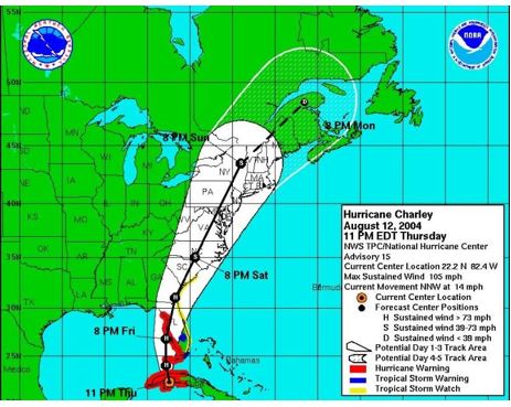
An NHC forecast track of Hurricane Charlie issued at 11 p.m. August 12, 1994.
During that morning, things began to change and those changes were fast and significant.
Radar and satellite photos indicated that rapid intensification was taking place. In the span of just three hours, Charley would strengthen from a Category 2 hurricane with maximum sustained winds of 110 mph to a strong Category 4 hurricane with maximum sustained winds of 145 mph. The maximum sustained winds then rose to 150 mph.
With the rapid intensification, Charley was now being steered by winds father up in the atmosphere that would allow it to curve rapidly to the northeast rather than north or north-northeast. I clearly remember thinking … this is not going to make it all the way up to Tampa.
This particular had some unique characteristics as compared to most other major hurricanes.
Hurricane Charley had a small eye diameter, as it approached Florida which contributed to its compact and intense nature. The eye, at its smallest, was varied from 5 to 6 miles in diameter. This small size meant that hurricane-force winds were concentrated in a relatively narrow area, causing localized but intense damage. Charley’s hurricane-force winds were confined to a relatively small area, roughly 10 miles wide. This compactness meant that the most severe impacts, like wind damage, were concentrated in a smaller area, but the intensity of the damage was severe !
Dr. Steve Lyons, TWC’s hurricane specialist at the time, was explaining all of these changes on the air. We indicated that areas well south of Tampa would now feel the highest impacts. Another interesting feature of Charley was that it was a very small hurricane with a six-mile diameter eye and a small eyewall around it. It looked quite small, overall, on satellite images.
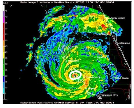
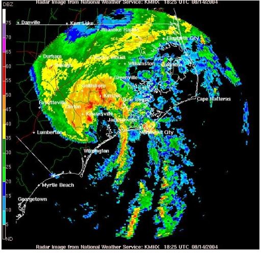
An NWS radar image of Hurricane Charley just after landfall on August 13, 2004, showed a tiny eye and eyewall.
So, what we were dealing with was rare, a very powerful hurricane with impacts that would only be around 10 miles from west to east. Now a strong Category 4 hurricane, Charley made landfall with a vengeance on Captiva Island, Florida, around midday and it unleashed tremendous fury on the town of Punta Gorda about an hour later.
After that, Charley tracked northeastward, toward Orlando. The hurricane hit Orlando as a Category 1 hurricane after midnight with maximum sustained winds of 85 mph. A couple of hours later, Charley passed near Daytona Beach and moved out into the Atlantic.
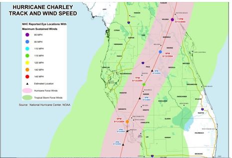
A map showing the track of Hurricane Charlie in the Florida Peninsula on August 13-14, 2004 – Map Credit-Lee County/NOAA.
Charley moved up along the South Atlantic Coast and made landfall near Cape Romain, SC on 14 August 14th as a Category 1 hurricane with maximum sustained winds of 80 mph.
It moved offshore and then came ashore again a few hours later near North Myrtle Beach, SC with maximum sustained winds of 75 mph.
Charley then interacted with an upper-level trough and was downgraded to a tropical storm. It moved back into the Atlantic Ocean near Virginia Beach, VA on August 15th and became extratropical.
Florida Impacts
The impacts over parts of Florida from Hurricane Charley were severe. There were 10 deaths and 20 indirect deaths attributed to the storm. Many residents of southwest Florida were taken by surprise at the intensity and destruction of Charley.
Remember, that much of the general public thought that Charley was going to make landfall up in Tampa. The Weather Channel wasn’t the only media entity that tried to warn residents of the rapid changes that were occurring before landfall. Several other meteorologists in local markets in southern and central Florida did the same.
Property damage was estimated at around five and a half billion dollars and nearly 300 million dollars in agricultural damage. Because of the small size of Charley, the storm surge wasn’t much more than 6 feet. Rainfall was held to 4 to 6 inches because of the pace of the hurricane.
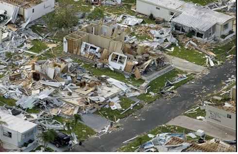
This photo shows severe damage from Hurricane Charlie at Punta Gorda, Florida. on August 13, 2004. Photo Credit – FEMA Library-Public Domain.
There was some tree damage in the Florida Keys as wind gusts reached 60 mph. Extreme to catastrophic damage occurred in parts of southwest Florida. Charley created an on a quarter-mile inlet on the northern part of Captiva Island. About half of the 300 homes on Captiva Island encountered severe damage.
The damage reached well inland. In the city of Arcadia in De Soto County, there was damage to 95 percent of the buildings. A shelter had its roof torn off leaving 3500 evacuees unprotected. In Florida alone, property damage was estimated at $14.6 billion.
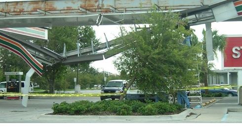
This photo shows damage to a gas station at Kissimmee, Florida on August 14, 2004, from Hurricane Charley. Photo Credit-Wikipedia-Public Domain.
There was also extensive damage around Fort Myers and Port Charlotte. Hurricane-force winds priced extensive property damage from Orlando to Daytona Beach, as well.
Other Impacts
In South Carolina, there were reports of hurricane-force wind gusts at Myrtle Beach. Flash flooding occurred in Charleston County. Damage in South Carolina totaled to 20 million dollars.
An NWS radar image shows a weakened Hurricane Charlie on August 14, 2004, in North Carolina.
In North Carolina, there was minor beach erosion along the coastline. Winds gusted to 70 mph, causing minor wind damage.
Charley spawned five weak tornadoes across the state including an F-1 in Nags Head that damaged twenty structures. Charley destroyed 40 houses and damaged 221 damaged beach homes in Sunset Beach Damage in North Carolina totaled to 25 million dollars. Scattered damage extended up to southeast Virginia.
Lessons From Charley
Although hurricane track forecasts have improved over the past 25 years and there has been some improvement in intensity forecast, meteorologists began stressing the cone of uncertainty rather just relying on one line to forecast the track of tropical cyclones.
Forecasts can still change and the public must be aware of this. If there is a tropical storm or hurricane headed your way try to keep up with the latest information and not what you heard two or three days ago.
Hurricanes are all unique and a category only indicated wind speed! A particular category can produce widely different impacts depending on its size and forward motion and the shape of the coastline. Fortunately, Charley’s small size and forward speed mitigated rainfall and surge issues but there was tremendous power in the confined area of Charley’s path.
Dr. Steve Lyons at The Weather Channel introduced a new term based on Charley’s tiny size. He called it a “vortcane”. The impacts were similar to a powerful upper-level disturbance (a piece of vorticity) in the atmosphere that of Charley in Florida produced extensive damage in confined areas. In fact, the damage pattern was more like a large tornado.


