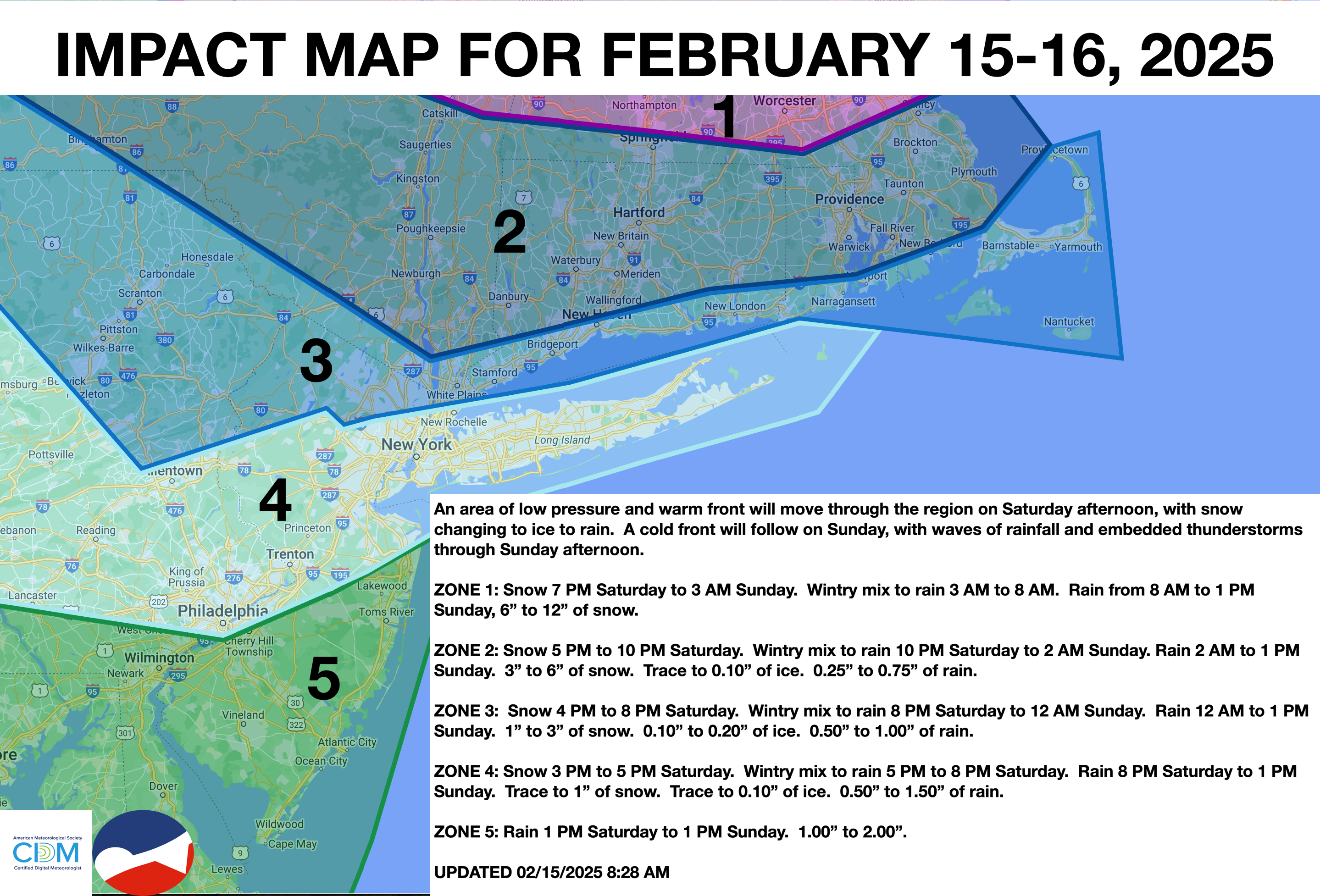
A wintry mix will invade the region with periods of snow, sleet, and rain. Rain will continue tonight through tomorrow with strong winds. A major winter storm is becoming increasingly likely by the end of next week.
TODAY
An area of low pressure will approach the region, with rain showers developing in southeastern Pennsylvania, central New Jersey, and southern New Jersey and snow showers in northeastern Pennsylvania, northern New Jersey, southeastern New York, and Connecticut. Snow accumulation up to 3″ is expected over the interior and locations north of New York City. The wintry mix transitioned to rain from south to north through the evening. Winds will veer from the northeast to the southeast at 5 to 10 mph. High temperatures will be in the lower to mid-30s over the interior and mid to upper 30s along the coast.
TONIGHT
Periods of rain will continue along and southeast of the I-95 corridor, while the wintry mix will change to rain by midnight. Winds will veer to the southwest at 5 to 15 mph. Low temperatures will be in the lower to mid-30s over the interior and mid to upper 30s along the coast.
TOMORROW
An area of low pressure and an arctic cold front will move through the region with periods of rain. Winds will veer from the southwest to northwest at 10 to 20 mph, with gusts over 30 mph. High temperatures will range from the upper 40s to lower 50s over the interior, mid to upper 50s in the New York City metropolitan area, and upper 50s to lower 60s in the Philadelphia metropolitan area.
TOMORROW NIGHT
A series of troughs will produce scattered clouds and flurries. Winds will be from the northwest at 10 to 20 mph, with gusts over 30 mph. Low temperatures will range from the upper 10s to lower 20s over the interior and mid to upper 20s along the coast.
MONDAY
A series of troughs will produce scattered clouds and flurries. Winds will be from the northwest at 10 to 20 mph, with gusts over 30 mph. High temperatures will range from the mid to upper 20s over the interior, upper 20s to lower 30s in the New York City metropolitan area, and lower to mid-30s in the Philadelphia metropolitan area.
TUESDAY
Scattered clouds are expected. Winds will be from the northwest at 5 to 15 mph. Low temperatures will range from the single digits to lower 10s over the interior, mid to upper 10s in the suburbs, and upper 10s to lower 20s in urban areas. High temperatures will range from the upper 10s to lower 20s over the interior and mid to upper 20s along the coast.
WEDNESDAY
Scattered clouds are expected. Low temperatures will range from the single digits to lower 10s over the interior and lower to mid-10s along the coast. High temperatures will range from the lower to mid-20s over the interior and mid to upper 20s along the coast.
THURSDAY
An area of low pressure will produce periods of significant accumulating snow. This storm may have the potential to produce snowfall of over 6 inches for the entire region. Low temperatures will range from the single digits to lower 10s over the interior and mid to upper 10s along the coast. High temperatures will range from the mid to upper 10s over the interior and lower to mid-20s along the coast.
FRIDAY
High pressure will produce scattered clouds. Low temperatures will range from the lower to mid-10s over the interior and upper 10s to lower 20s along the coast. High temperatures will range from the upper 10s to lower 20s over the interior and lower to mid-20s along the coast.
SATURDAY
High pressure will produce scattered clouds. Low temperatures will range from the lower to mid-10s over the interior and mid to upper 10s along the coast. High temperatures will range from the mid to upper 20s for highs.