Cloudy but dry conditions today will give way to a wintry mix mess by early tomorrow morning. Another wintry mix is expected by Saturday evening. A major winter storm is possible by next week.
TODAY
High pressure will produce dry conditions with cloudy skies. Winds will be light and variable. High temperatures will range from the mid to upper 20s over the interior and lower to mid-30s along the coast.
TONIGHT
A warm front will approach the region, with increasing clouds and snow developing after midnight. Winds will veer to the southeast at 5 to 15 mph. Low temperatures will range from the lower to mid-20s over the interior, mid to upper 20s in the suburbs, and upper 20s to lower 30s in urban areas.
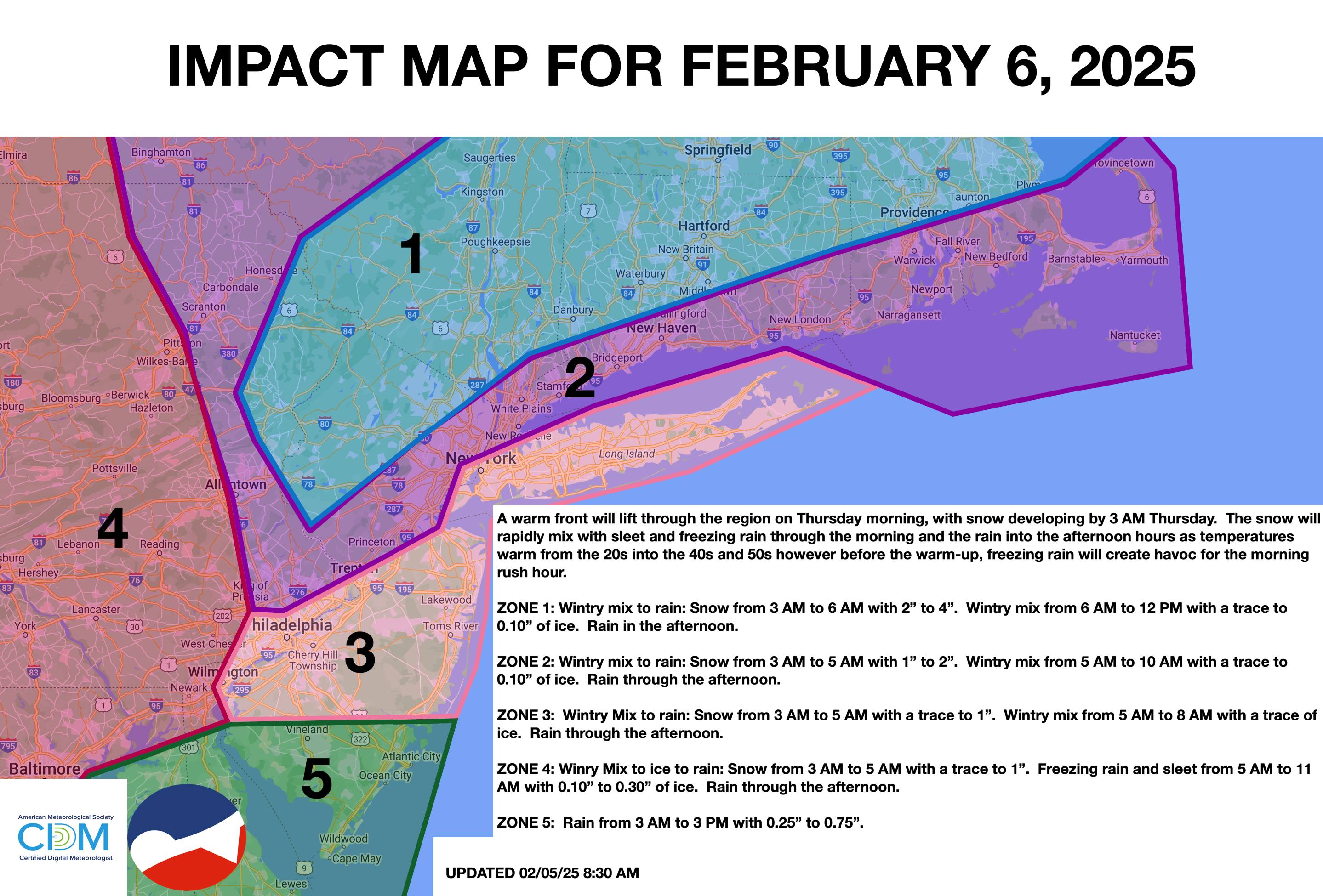
TOMORROW
A warm front will lift through the region, with snow mixing with sleet and freezing rain by daybreak and over to rain by the late morning hours. Rain will continue through the early afternoon. Snow and ice accumulation is expected along and northwest of the I-95 corridor, while mostly rain can be expected to the southeast. Winds will veer to the southwest at 5 to 15 mph. High temperatures will range from the mid to upper 30s over the interior, upper 30s to lower 40s in the New York City metropolitan area, and lower to mid-40s in the Philadelphia metropolitan area.
TOMORROW NIGHT
High pressure will build into the region with clearing skies. Winds will veer to the west at 5 to 15 mph. Low temperatures will range from the mid to upper 20s over the interior, lower to mid-30s in the suburbs, and mid to upper 30s in urban areas.
FRIDAY
High pressure will produce scattered clouds. Winds will veer to the northwest at 5 to 15 mph. High temperatures will range from the upper 20s to lower 30s over the interior, mid to upper 30s in the Delaware River Valley, and upper 30s to lower 40s along the coast.
SATURDAY
A warm front will approach with a wintry mix of snow, sleet, and rain by the evening. Winds will be from the north at 5 mph. Low temperatures will range from the mid to upper 10 over the interior and lower to mid-20s along the coast. High temperatures will range from the upper 20s to lower 30s over the interior and lower to mid-30s along the coast.
SUNDAY
An area of low pressure will move through the region with periods of rain in the morning followed by clearing skies. Low temperatures will range from the upper 20s to lower 30s over the interior and lower to mid-30s along the coast. High temperatures will range from the mid to upper 30s over the interior and lower to mid-40s along the coast.
MONDAY
High pressure will produce scattered clouds. Low temperatures will range from the lower to mid-10s over the interior, upper 10s to lower 20s in the suburbs, and lower to mid-20s in urban areas. High temperatures will range from the upper 20s to lower 30s over the interior and lower to mid-30s along the coast.
TUESDAY
An area of low pressure will produce periods of snow. Low temperatures will range from the lower to mid-20s over the interior and mid to upper 20s along the coast. High temperatures will range from the mid to upper 20s over the interior and upper 20s to lower 30s along the coast.
WEDNESDAY
An area of low pressure will exit the region with periods of snow, sleet, and rain. Low temperatures will range from the mid to upper 20s over the interior and upper 20s to lower 30s along the coast. High temperatures will range from the upper 20s to lower 30s over the interior and lower to mid-30s along the coast.