

Many areas across the South just experienced a major winter storm which deposited record amounts of snow in some locations like New Orleans, Louisiana and Mobile, Alabama. The Weather Channel named it “Winter Storm Enzo” We are now going to take you back to early February of 1973 when a large portion of the Southeast US (mainly southern Alabama to the Carolinas) was pummeled by a notorious winter storm of its own.
Back in the 1970s, snowstorms weren’t named but the National Weather Service called this one “The Great Southeastern Snowstorm of 1973”. This extremely rare weather event dumped from one to two feet of snow over a large portion of the southeastern U.S. Strangely, the snowstorm event missed several major cities in the region such as Birmingham and Atlanta. The snow came as a major surprise to locations that were not even remotely prepared for such a remarkable event.

An ATS-3 Satellite image (post-storm) showing snow cover across parts of the Southeast U.S. on February 11, 1973. Photo Credit- NOAA-NWS.
An Incredible Winter Storm
After a period of mild conditions, some very cold air spilled down into the southern U.S. on Thursday, February 8th. There were reports of light snow and freezing rain across parts of southern and southeast Texas and into Louisiana.
On Friday, freezing rain changed to a period of snow before ending across southern Louisiana and Mississippi, with snow accumulations of 1-3 inches. Snow spread across Alabama, Georgia, and the Carolinas, while freezing rain and sleet fell across coastal South Carolina, Georgia, and Alabama between areas of snow and rain.

A photo taken in Mobile, Alabama, after over 3 inches of snow fell on February 9, 1973. Credit NWS Mobile via Mobile Press-Register.
From Friday night into Saturday, a “nuisance” winter storm began to change its personality in a hurry. Suddenly, the intensity of the snow increased dramatically! Moderate to heavy snow developed across central Georgia, most of South Carolina and eastern North Carolina. Lightning and thunder accompanied the snow at Augusta, Georgia, at 3 a.m., in Florence, SC at 6 a.m., Wilmington, NC at noon, and in New Bern, NC at 2 p.m.
Snowfall rates of one to two inches per hour were reported on Saturday resulting in a band of snow about 50 miles wide. Snowfall totals over one foot extended across Georgia and into South Carolina and up to North Carolina. Rimini, South Carolina, located just west of I-95 and south of Sumter, recorded a whopping two FEET of snow! Columbia picked up an incredible 16 inches. Ironically, the snow fell south of Atlanta where cloudy skies and temperatures in the upper 20s were reported on February 10th.
Storm Impacts
The amount of snow was much more than the region could bear. This region of the nation neither anticipated this kind of a snowstorm nor did they have even the slightest ability to deal with it.
The sudden increase in snowfall rates across Georgia and South Carolina wreaked havoc on the roadways. Several folks who had to endure this event described the wind as “cutting through you like knives with large flakes of snow falling.” Light snow was in the forecast but it just kept snowing and snowing and snowing according to one resident of Summerton, South Carolina.
Residents and travelers alike, in South Carolina, were shocked by the storm. On Interstate 95 in North and South Carolina, cars, trucks and 18 wheelers were stuck, stranded or they had skidded off of the road. In South Carolina, farmers and loggers from the area lent their heavy equipment to help folks stranded in the snow.

An image of Sumter, South Carolina, after the snowstorm of February 9-10, 1973. Image Credit-YouTube.
The National Guard sent helicopters to rescue hundreds of travelers from their cars that were buried in snow. An article from wist.com quoted one National Guardsman. “The helicopters fly along where they thought the roads were and what would happen is, people would hear the helicopter and they would come out of the snow because the cars were buried and he would just see people emerge.”
Snow drifts in parts of South Carolina were up to 8 feet high! The National Guard sent helicopters to airlift food for stranded residents. In Columbia, South Carolina, where 16 inches of snow fell. Some roofs collapsed due to the weight of the snow. After the storm ended on Saturday, the temperature at Columbia fell to 5 degrees above zero.
Shelters were opened at local schools. Residents of local towns like Summerton were taking people into their homes. Families were stranded in their homes and workplaces. The roads in the county were impassable.
Local hotels and guest houses took in stranded motorists, many of whom were traveling down I-95 to Florida. Some guests were asking when the road plows would be coming through. They were told that there were no road plows or even ways the clear the snow. In many locations, it took up to four days to untangle from the storm’s mess.
The storm didn’t miss Charleston, South Carolina, as over 7 inches of snow fell there.

An image showing snow after the storm of (February 9-10 1973) in Charleston, South Carolina. Image Credit-YouTube.
Around Macon, Georgia, where 16 inches of snow piled up, roads became impassable. National Guard and Civil Defense units were called out to try to clear at least some roads.
 A photo of a residence in Macon, Georgia, after the snowstorm of February 9-10, 1973 dumped 16 inches of snow. Credit-YouTube.
Over 1,000 travelers on Interstate 75 sought shelter as their trip south to Florida was delayed. The Interstate was closed for nearly 200 miles from north of Macon down to Valdosta, Georgia. Just like I-75, thousands of cars were stranded along the highway.
In Thomaston, Georgia, where over 19 inches of snow was reported, cars, trucks, and buses that were stuck on bridges had to be manually pushed off.
Many homes in the area lost power and some residents invited their neighbors over to huddle around space heaters to get warm.
All in all, eight people lost their lives in this storm and storm damages totaled $30 million to homes, roads, and businesses. That would be over $200 million today!
Meteorological Conditions
A cold front pushed southward to the Gulf of Mexico on February 8th. A disturbance aloft triggered the formation of low pressure along the front in the Gulf. Moisture from the Gulf moved northward over the frontal boundary resulting in an area of snow, sleet and freezing rain from southern Texas through Louisiana overnight and into the morning of February 9th.
Over an inch of snow fell at Houston, Texas, and New Orleans, Louisiana picked up less than a half inch of snow. A trough of low pressure aloft swung into the area and it phased with the Gulf system and the surface low began to intensify rapidly as it moved eastward in the northern Gulf toward Florida.

An upper-level weather map of the Southeast U.S. (February 10, 1973) showing a deepening trough of low pressure over the region. Map Credit- NOAA-NWS.
Over 3 inches of snow fell at Montgomery and Mobile in Alabama but Union Springs, located southeast of Montgomery, picked up 13 inches. From southeast Alabama, through central Georgia and South Carolina, to southeast North Carolina, over a foot of snow fell.
As the low moved off of the Southeast Coast, it became continued to grow stronger and it produced more wind while bringing even more cold air southward. Rain and mixed precipitation changed to all snow as far south as Tallahassee, Florida, Valdosta, Georgia; and Savannah, Georgia.
Snow fell in the Florida Panhandle as amounts ranged from a trace to 3 inches. Tallahassee picked up about a half inch of snow. Trace amounts of snow were reported in Florida from Jacksonville, to just north of Orlando.

A surface weather map (features and precipitation) in the Southeast U.S. on February 10, 1973. Map Credit- NOAA-NWS.
Much of South Carolina recorded one to two feet of snow. In North Carolina, the airport at Raleigh was closed with over as over 4 inches of snow fell. The hardest hit area of the state was in the southeast where over a foot was recorded.
Morehead City picked up 16.5 inches. Wind gusts exceeded 40 mph across eastern North Carolina and that led to areas of blowing snow with visibility falling to near zero in many locations during the evening of February 10th.
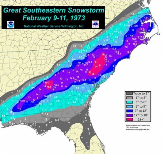
A map showing snowfall totals across the Southeast from the storm of February 9-10, 1973). Map Credit-NOAA-NWS Wilmington, NC.
It doesn’t happen often but highly impactful winter storm CAN occur in the South ! Forecasting methods and much better today and there has been improvement to prepare for winter storms and snow removal during and after the storm

