Cold and dry conditions this weekend will give way to a winter storm for the Philadelphia metropolitan area and southern Mid-Atlantic by Monday. Cold and unsettled conditions will continue through next week.
TODAY
A series of troughs will produce scattered clouds and a few flurries. Winds will be from the northwest at 10 to 20 mph. Temperatures will range from the mid to upper 20s over the interior and lower to mid-30s along the coast for highs.
TONIGHT
High pressure will produce scattered clouds. Winds will be from the northwest at 5 to 15 mph. Temperatures will fall into the lower to mid-20s for lows.
TOMORROW
High pressure will produce scattered clouds. Winds will be from the northwest at 5 to 15 mph. Temperatures will rise into the mid to upper 20s over the interior and lower to mid-30s along the coast for highs.
TOMORROW NIGHT
An area of low pressure will approach the region with increasing clouds and snow developing towards daybreak. Winds will be from the northwest at 5 to 10 mph. Temperatures will fall into the lower to mid-20s for lows.
MONDAY
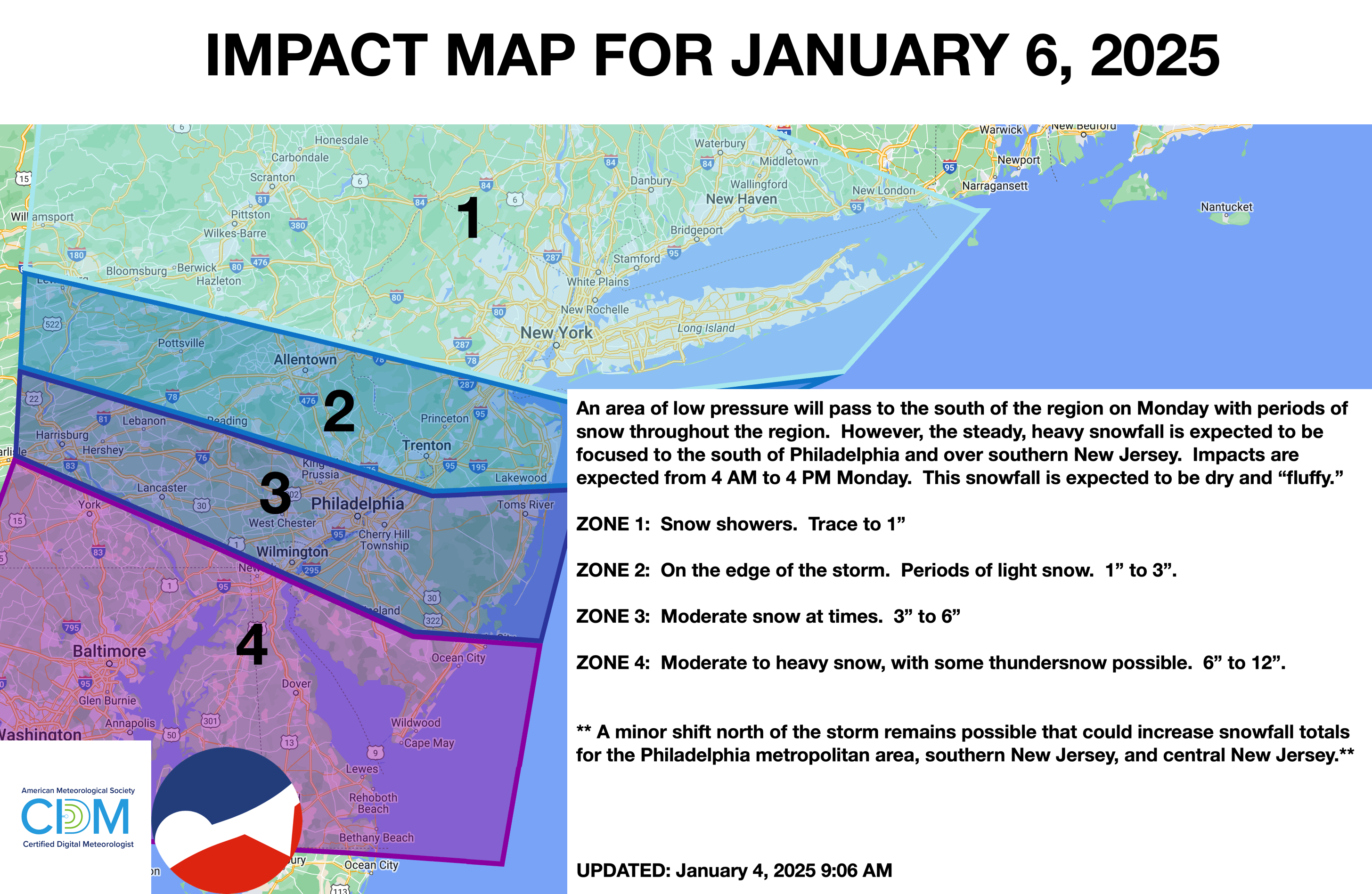
An area of low pressure will pass to the south of the region with scattered snow showers over the interior and New York City metropolitan area while steady moderate to heavy snowfall can be expected throughout the Philadelphia metropolitan area, central New Jersey, and southern New Jersey. See the snow map below for details. Winds will be from the northwest at 5 to 15 mph. Temperatures will rise into the mid to upper 20s for highs.
TUESDAY
A series of troughs will move through the region with scattered snow showers. Temperatures will range from the lower to mid-10s over the interior and upper 10s to mid-20s along the coast for lows and upper 10s to lower 20s over the interior and mid-20s to lower 30s along the coast for highs.
WEDNESDAY
A series of troughs will move through the region with scattered snow showers. Temperatures will range from the lower to mid-10s over the interior and upper 10s to mid-20s along the coast for lows and upper 10s to lower 20s over the interior and mid-20s to lower 30s along the coast for highs.
THURSDAY
A series of troughs will move through the region with scattered snow showers. Temperatures will range from the lower to mid-10s over the interior and upper 10s to mid-20s along the coast for lows and upper 10s to lower 20s over the interior and mid-20s to lower 30s along the coast for highs.
FRIDAY
High pressure will produce scattered clouds. Temperatures will range from the lower to mid-10s over the interior, upper 10s to lower 20s in the suburbs, and lower to mid-20s in urban areas for lows and mid to upper 20s over the interior and lower to mid-30s along the coast for highs.
SATURDAY
An area of low pressure and a cold front will produce periods of snow showers. Temperatures will range from the lower to mid-20s over the interior and mid to upper 20s along the coast for lows and mid to upper 20s over the interior and lower to mid-30s along the coast for highs.