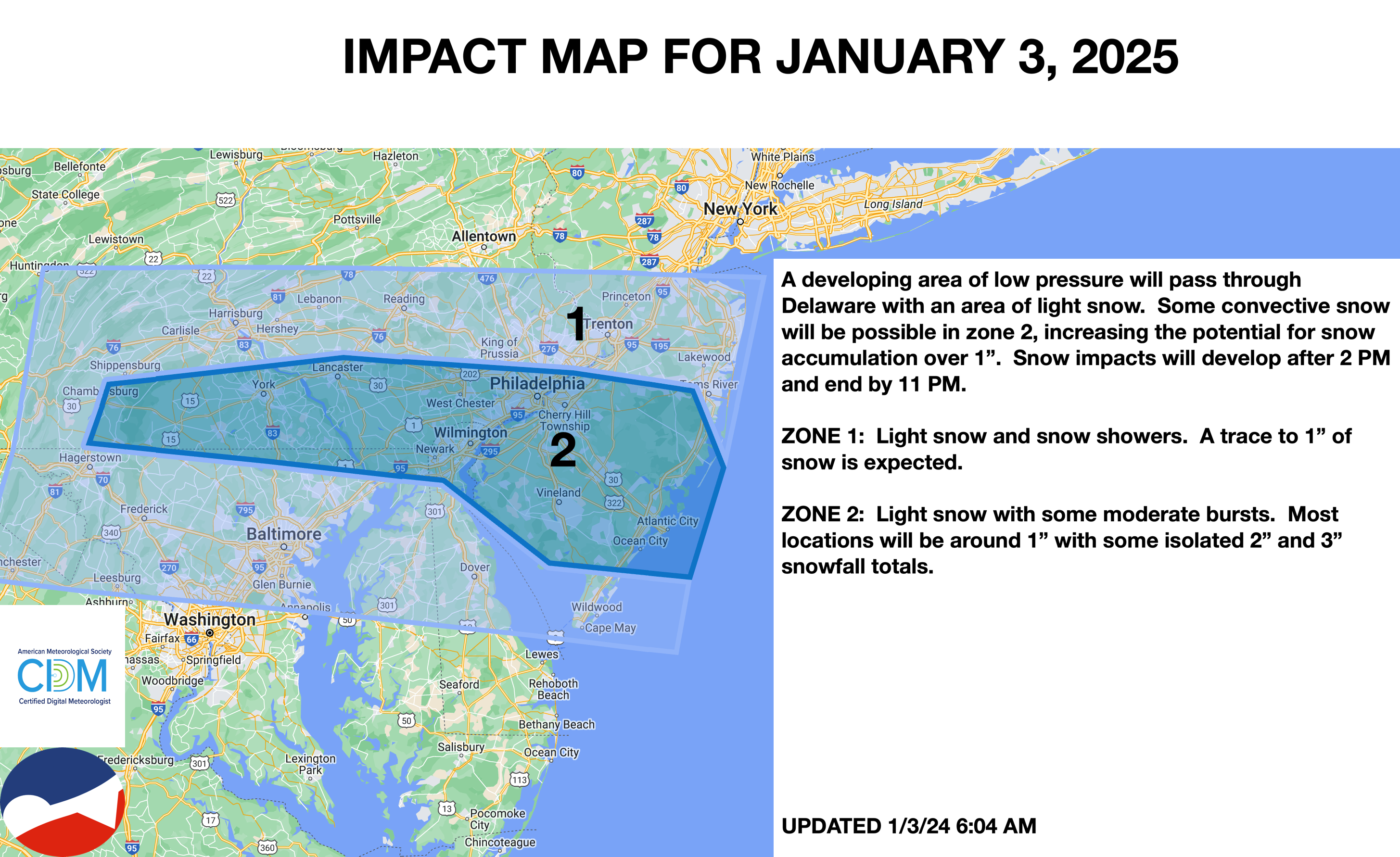
Light snow invades the Philadelphia metro and southern New Jersey this afternoon and evening as an appetizer for more significant snowfall potential on Monday morning.
TODAY
A series of troughs will produce scattered clouds and a few flurries. Light snow will move into southeastern Pennsylvania and southern New Jersey in the afternoon. Winds will be from the west at 5 to 15 mph. Temperatures will rise into the lower to mid-30s over the interior and mid to upper 30s along the coast for highs.
TONIGHT
An area of low pressure will move through the region with a few flurries over the interior and New York City metropolitan area and a period of light snow in the Philadelphia metropolitan area and southern New Jersey. Snow accumulations up to 3″ will be possible in southern New Jersey. Winds will be from the northwest at 5 to 15 mph. Temperatures will fall into the lower to mid-20s over the interior and mid to upper 20s along the coast for lows.
TOMORROW
A series of troughs will produce scattered clouds and a few flurries. Winds will be from the northwest at 10 to 20 mph. Temperatures will range from the upper 10s to lower 20s over the interior and mid to upper-20s along the coast for lows and lower to mid-20s over the interior and upper 20s to lower 30s along the coast for highs.
TOMORROW NIGHT
High pressure will produce scattered clouds. Winds will be from the northwest at 5 to 15 mph. Temperatures will fall into the lower to mid-20s for lows.
SUNDAY
High pressure will produce scattered clouds. Winds will be from the northwest at 5 to 15 mph. Temperatures will rise into the mid to upper 20s over the interior and lower to mid-30s along the coast for highs.
MONDAY
An area of low pressure will approach the region with periods of snow in southeastern Pennsylvania, central New Jersey, and southern New Jersey and snow showers further north. Accumulating snowfall is likely from central New Jersey and the Philadelphia metropolitan area and points to the south. Winds will be from the northwest at 5 to 10 mph. Temperatures will range from the upper 10s to lower 20s over the interior and lower to mid-20s along the coast for lows and mid to upper 20s over the interior and upper 20s to lower 30s along the coast for highs.
TUESDAY
A series of troughs will move through the region with scattered snow showers. Temperatures will range from the mid to upper 10s over the interior and upper 10s to lower 20s along the coast for lows and lower to mid-20s over the interior and upper 20s to lower 30s along the coast for highs.
WEDNESDAY
A series of troughs will produce flurries. Temperatures will range from the mid to upper 10s over the interior and upper 10s to lower 20s along the coast for lows and lower to mid-20s over the interior and upper 20s to lower 30s along the coast for highs.
THURSDAY
A series of troughs will produce flurries. Temperatures will range from the single digits to lower 10s over the interior and lower to mid-10s along the coast for lows and upper 10s to lower 20s over the interior and lower to mid-20s along the coast for highs.
FRIDAY
High pressure will produce scattered clouds. Temperatures will range from the upper 10s to lower 20s over the interior and mid to upper 20s along the coast for lows and mid to upper 20s over the interior and lower to mid-30s along the coast for highs.