

Many powerful storms have swept into the Pacific Northwest over the decades but the Columbus Day Storm of 1962 (a.k.a. “Big Blow”) remains the “benchmark”! This beast was one of the most powerful nontropical storms to strike the U.S. and it produced over two and a quarter billion (2024 dollars) of damage from northern California to Washington.
“Buzz” Bernard is a retired meteorologist and best-selling author who I had the pleasure of working with at The Weather Channel. He grew up and attended college in the Pacific Northwest and he experienced this storm firsthand. Below are his recollections.
“For all practical purposes, with gusts over 100 mph, Portland was hit by the “eyewall” of a hurricane. Thousands of trees were downed. But my dad and I made it to a football game the following day at Multnomah Stadium. Washington Huskies vs. Oregon State Beavers. The Huskies came from behind to win. Anecdote: my Uncle John decided to try to manually hold the roof of his house in place during the storm. But he abandoned the idea when he started going up and down with the roof. Fortunately, the roof stayed put.”
Storm History
This monster storm carried some (DNA) from a Pacific typhoon (Freda). It became extratropical and moved toward the U.S. West Coast. As it approached the coast of Northern California, it turned northward and rapidly intensified. Rain from this storm canceled the sixth game of the 1962 World Series between the Giants and the Yankees. Over four inches of rain inundated the San Francisco Bay area.
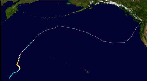
Track of October 1962 Pacific Typhoon Freda which transitioned to an extratropical storm that became the Columbus Day Strom of 1962. Credit-NASA/NOAA.
This historic storm’s central pressure crashed below 960 millibars as it moved northward just off the Oregon Coast. Some incredible wind gusts, especially for a non-tropical storm, were recorded. A gust of 170 mph was recorded at Mt. Hebo on the northern Oregon Coast. Cape Blanco saw wind gusts to 145 mph before the anemometer failed. The Naselle radar station on the southwest Washington Coast recorded a gust of 160 mph.
There were also impressive gusts inland. Gusts reached 127 mph at Corvallis, Oregon, and exceeded 100 mph in the Portland area.
The storm began to weaken as it moved northward off the coast of Washington before turning inland in British Columbia.
Wind gusts over hurricane force were recorded in the Seattle area, however. Meteorologist Wolf Read said that the tropical origin of the storm probably influenced its incredible strengthening later as an extratropical storm.
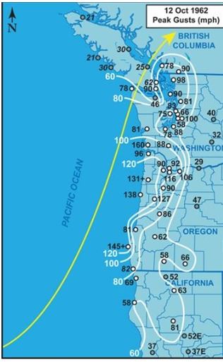
The map above indicates the track and peak wind gusts for the Columbus Day storm of 1962. Credit- Meteorologist Wolf Read.
Storm Impacts
Needless to say, winds of this magnitude can produce an incredible amount of damage. Western Oregon took the worst of what this storm had to offer. The Willamette Valley of Oregon was particularly hard hit. A majority of homes were damaged or destroyed. In rural areas, barns collapsed which killed livestock.

This photo shows a home in Newberg, Oregon, that was destroyed by the Columbus Day Storm of 1962. Credit-Wikimedia Commons/Public Doman.
Tree damage from northern California to Washington was way beyond belief!
In less than 12 hours, more than 11 billion board feet of timber was blown down in northern California, Oregon, and Washington combined; some estimates put it at 15 billion board feet. This exceeded the annual timber harvest for Oregon and Washington at the time.

The photo shows major tree damage in Oregon from the Columbus Day Storm in 1962. Credit-NWS.
Transmitting towers for radio and TV stations in the Portland area were destroyed and some stations weren’t able to transmit for three to four months. The city experienced extensive damage to homes and businesses.
A wind gust of 127 mph was recorded at Corvallis, Oregon. Weather observers in Corvallis had to flee the station during the storm and the 3 p.m. observation was missing.

Weather observations for Corvallis Oregon October 12, 1962. (notation that the station was abandoned) . Credit- Oregon Climate Services
Power lines and transformers were destroyed all across northwest Oregon. Power was not restored for several weeks. Many roads were blocked and impassable and several bridges were damaged.

A photo shows workers inspecting a bridge damaged by the Columbus Day Storm of 1962. Credit – Oregon State University.
Washington state had its own set of problems from the storm.
There were trees down everywhere in Snoqualmie. According to one account school buses that transported students for the Snoqualmie Falls School District had men with chainsaws cutting trees off the roads to get the kids home.
In Tacoma, the power went out across the city, and many streets were blocked by falling trees. Pacific Avenue was completely covered with broken glass from all the blown-out windows.
Seattle felt the brunt of the storm by early evening. There was widespread loss of power with tree and power line damage across the metro area and many streets were blocked. At the Seattle World’s Fair, officials closed the Coliseum at 7:30, worried that glass windows might blow out. The Space Needle closed lines for the elevators, but diners in the “Eye of the Needle” were allowed to complete their meals.

A photo showing fallen trees blocking a street and crushing a car – Columbus Day Storm of 1962. Credit- seattle.gov.
Forecast Challenges
Computer models at that time, were primitive and unreliable, especially for storms that intensify rapidly and they did a poor job of forecasting the severity of this event.
The forecast called a much weaker storm with only scattered showers, with the storm turning into southern Oregon. A couple of meteorologists at the U.S. Weather Bureau in Seattle did realize that a significant storm was coming and a few hours of lead time was communicated to the public.
All told, 46 fatalities were attributed to this historic storm, more than any other Pacific Northwest weather event.

