

On the evening of September 26, 2024, Category 4 Hurricane Helene slammed into the coast of Florida’s Big Bend area. Helene was the FOURTH major hurricane that made landfall on the Florida Panhandle Coast since 2018.
The first was Hurricane Michael which produced catastrophic damage to towns like Mexico Beach and Panama City in Florida! Michael was originally labeled a Category 4 hurricane but that was revised later to a Category 5 hurricane after damage inspection was completed across the area.
Michael’s Journey – Formation To Disaster
On October 2, 2018, a couple of innocuous weather systems interacted in the southwest Caribbean Sea to form a general area of low pressure. Some convective thunderstorm activity began to develop and the National Hurricane Center began to monitor the system for possible tropical development.
Wind shear temporarily hindered development but the general circulation began to move toward the Yucatan Peninsula and western Cuba. The NHC then began to issue advisories on “Potential Tropical Cyclone 14” on October 6th.
Early on October 7th, radar from Belize indicated a closed area of low pressure. Satellite data indicated the same thing. The low was then classified as a tropical depression.
The upper-level environment was favorable for development and it didn’t take long before the depression became Tropical Storm Michael on October 8th. Fighting off some wind shear, Michael became a Category 1 hurricane later in the day. Many tropical cyclones that take this track northward come in contact with either the Yucatan Peninsula or Cuba, but Michael split between the two through the Yucatan Channel and barely clipped the western edge of Cuba as it moved into the Gulf of Mexico.
As it moved into the Gulf, Michael continued to rapidly intensify with explosive convection within a developing eyewall and it was a strengthening Category 2 hurricane. By early afternoon on October 9th, Michael became a “major” hurricane as it attained Category 3 status. There was no stopping this beast by the end of the day. Michael became “historic” as it reached Category 5 strength with maximum sustained winds of 160 mph. It was taking direct aim at part of the Florida Panhandle Coast.
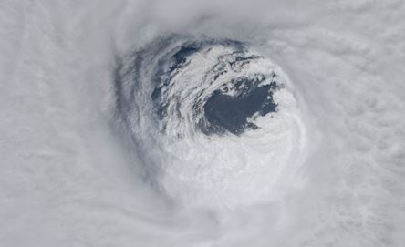
The photo shows the eye of Hurricane Michael just before landfall on October 10, 2018, as seen from the International Space Station. Image Credit-NASA.
Preparations
On October 7th, Florida Governor Rick Scott declared a state of emergency for 26 counties in the state. Nine more counties were added on October 8th. Governor Scott also requested an emergency disaster declaration for the 35 counties on October 9th and President Trump approved the request.
Mandatory evacuation orders were issued for Bay, Gulf, and Wakulla Counties on October 8th for residents in coastal areas or those living in weak dwellings. Florida State University, Tallahassee Community College, and Florida A&M Unversity campuses were closed from October 9th through 12th. All public schools were closed in 26 counties. The National Hurricane Center issued Hurricane and Tropical Storm Warnings along much of the Florida Panhandle Coast.
Up to 375,000 people were ordered to evacuate coastal areas as the powerful hurricane approached. A storm surge of 14-15 feet was projected.
In Georgia, Governor Nathan Deal declared a state of emergency for 92 counties across the southern half of the state on October 9th. Most public schools and colleges were closed. Atlanta Motor Speedway, south of the city opened its grounds for free to evacuees.
Governor Deal also requested an emergency disaster declaration for the 35 more counties on October 9th and President Trump approved the request.
Poor Areas Ill-Prepared For Disaster
Before I get to the details of this monster storm, I thought that I would give you some background information about the area that was affected. I moved to Atlanta, Georgia, in the early 1980s to work for The Weather Channel. Since then I have made frequent trips to the beaches in the Florida Panhandle area. On the way there, you have to pass through either southwest Georgia or southeast Alabama.
As you drive southward and down into the Florida Panhandle, you pass through mainly agricultural areas. Farther south, you see many mobile homes or homes that are not well constructed. You pass through some tiny towns and villages where the poverty rate is greater than 40 percent.
The coastal area has built up considerably since the 1980s. Condominium complexes line the beaches for miles around the Destin area. Areaseast of Destin has only recently been developed. Panama City has been a popular vacation spot for years. Just east of Panama City is Tyndall Air Force Base. Eastward from there, development is sparse but there is the small village of Mexico Beach. I did stay there for a couple of nights one time in the mid-1980s to avoid the crowds of Panama City.
Michael’s Landfall And Extreme Impacts
Hurricane Michael was a well-forecasted storm. Even a couple of days before landfall, an area between Panama City and Port St. Joe was seen as the most probable area for landfall. Although the beach locations were mostly evacuated, some television networks like ABC set up cameras and crews in Mexico Beach. To me, that seemed gusty and even dangerous. The Weather Channel set up a bit farther west around Panama City Beach, which would be on the west, or slightly weaker side, of the hurricane.

The map indicated the track of Hurricane Michael to the Florida Panhandle and beyond in October of 2018. Map Credit-NWS
Many meteorologists, like me, were tracking the hurricane by satellite and radar during the late morning of October 10th as Michael approached the coast. We also could watch the storm in real-time as it turned out.
At 12:30 p.m. CDT, Hurricane Michael made landfall between Tyndall Air Force Base and Mexico Beach with maximum sustained winds of 160 mph on October 10th. Mexico Beach was basically “ground zero” for the storm. The scene was surreal, Not only was Mexico Beach receiving Category 5 hurricane winds but a storm surge of 14 feet rushed into the town from the Gulf of Mexico.

A radar image of Hurricane Michael as it was making landfall just east of Panama City, Florida. on October 10, 2018. Image credit NWS.
A wind gust of 139 mph was recorded at Tyndall Air Force Base before the recording instrument failed. That occurred before the eyewall moved into that location! Every building on the base was damaged and many were destroyed. Mexico Beach was laid to waste. Most homes and buildings were destroyed and flattened.

This areal photo shows the mass devastation around Mexico Beach, Florida in icted by Hurricane Michael on October 10, 2018. Image Credit-NWS.
Remnants of homes were scattered all over U.S. Route 98. Much of the road’s pavement was washed away. Parked vehicles were tossed around and destroyed. Other businesses, hotels, and apartment buildings were similarly destroyed. The scene was described by many as like a war zone!
Well to the east, at Port St.Joe, an 8-foot storm surge produced extensive damage and it washed boats and debris into the streets of the town.
To the west, the western eyewall of Michael moved over Panama City. There was extreme damage at Panama City Beach. In Panama City, widespread damage was reported. There was major structural damage to school businesses, stores and restaurants. Many homes lost roofs and walls. TV and radio stations in Panama City were knocked off the air. Tree damage was incredible, all the way inland to parts of Georgia and Alabama. Power was lost for several days.

This photo shows extensive damage in Panama City, Florida from Hurricane Michael on October 10, 2018. Photo Credit-Public Domain.
In an article in Panama City’s newsherald.com high school student, Alexis Taylor described the storm after her family evacuated to a safe spot in Panama City.
“Watching the power lines snapping and throwing off blue electric sparks in all directions outside the house my ve siblings and parents had evacuated to north Panama City. Watching my stepdad and grandpa struggle to hold up a mattress to block Michael’s fury after the windows blew out and the family huddled in the center room and feeling my hands hit the water as I sat in that room singing psalms at the height of the storm.”
Extensive damage was reported inland, as well. The brunt of Michael was felt west of Tallahassee but wind gusts still exceeded 70 mph there. Trees and power lines were toppled all over the place and over 100,000 customers were without power. Many residents waited days for power to be restored.
Michael was still a hurricane as it moved from the Florida Panhandle into Georgia. The damage was extensive and severe in the Lake Seminole area. There was extensive property damage in the southwest Georgia town of Donalsonville where a wind gust of 115 mph was reported. Albany, Georgia, reported numerous trees and power lines down and they reported a wind gust of 90 mph. Over 100 roads in Georgia were blocked and over 400,000 customers were without power.
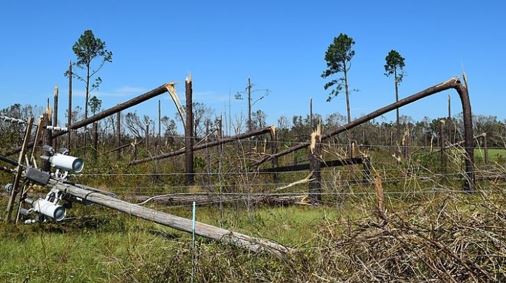
This photo shows downed trees and power lines along Georgia State Road 263 in Seminole County after Hurricane Michael passed by. Photo Credit-Wikipedia-Public Domain.
Tropical-storm-force winds were reported up to Atlanta and Athens. Michael spawned several tornadoes, including one in Fulton County, Georgia. Agricultural damage across the southern half of Georgia approached 3 billion dollars, and forestry losses totaled about one billion dollars.
Michael remained a tropical storm, and it produced significant damage in the Carolinas. Nearly 500,000 customers were without power in North Carolina. All told, Michael was responsible for 59 deaths in the US.
Long Road To Recovery
One year later, many locations had seen little to no progress in recovery efforts. Residents of many towns felt abandoned. Because of the high poverty rate, a high percentage of those affected were underinsured or had no insurance at all. Because of the relatively low population in the counties affected the tax base was low, to begin with, so funding was at a minimum.
Clean-up and rebuilding efforts were slow and tedious, as there was still a good deal of rubble around Mexico Beach. and clean-up operations continue. A town of around 1,200 hundred residents had lost about half of its population. Nearly 70 percent of the trees in Panama City and surrounding Bay County were destroyed by Michael’s winds. Many of those trees provided shade for hot summer days.
In Panama City, the rebuilding efforts were extremely slow for quite some time.
In Bay County, thousands of students have left the district and several schools have been consolidated. A major concern is the impact the trauma has on students’ mental health. The pandemic made the situation even worse.
Since 2021 the rebuilding effort in Mexico has reintensified and today the town has been restored, and then some as a housing boom continues,
The first full-scale beach nourishment of Mexico Beach will begin soon with an anticipated completion date of May 1, 2025

A recent photo of Mexico Beach shows that restoration projects have been successful with many new houses and commercial buildings featured. Photo Credit-mexicobeach.com.
Restoration projects in Panama City and Panama City Beach have also been successful. Fortunately, the center of Hurricane Helene passed far enough east for them to escape the devastating winds and storm surge. Hopefully, that will continue to be the case but the Gulf of Mexico water temperatures have been alarmingly high over the past couple of years!

