

The U.S. East Coast and Gulf Coast aren’t the only areas that have to deal with tropical cyclones. Plenty of tropical storms and hurricanes form in the eastern Pacific. Impacts from these systems can make their way to the southwestern U.S. An extreme example occurred in 1983 when abundant moisture from Tropical Storm Octave flowed into the Southwest resulting in massive flooding and over a dozen deaths.
Tropical Storm Octave – September 1983
Tropical Storm Octave developed from an area of disturbed weather in the eastern Pacific on September 23, 1983. The disturbance moved west for four days before becoming a tropical depression on September 27th off the southwest coast of Mexico. After that, it strengthened to a tropical storm (Octave) with maximum sustained winds of 50 mph. Some wind shear kept Octave from growing stronger.
By September 30th, Octave began to move quickly to the northeast, it weakened to a tropical depression over cooler waters and finally dissipated three days later.
Although the center of Octave never reached the U.S. its deep tropical moisture did. Octave’s moisture was funneled northeastward into southeast Arizona and parts of New Mexico and hung around for days.
Octave’s Impacts
Rain moved into Arizona on September 28th. Rainfall for the year was already well above average resulting from a wet winter season followed by an active summer monsoon. The state couldn’t handle much more rain, but a whole lot more rain inundated the area.
On September 29th. heavy rain and strong thunderstorms swept across southeast Arizona. After a break on the 30th, more heavy rain developed at midnight on October 1st and continued through much of the morning hours.
The flooding became serious and widespread. Riverbank erosion cut into bridge pilings, homes, and businesses. Almost every low-water crossing in Tucson flooded as police and fire departments were overwhelmed with calls for help.
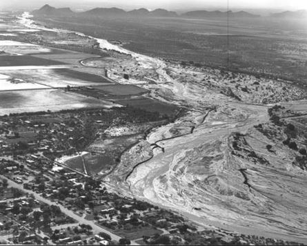
A photo of Tucson, Arizona shows widespread flood damage triggered by Tropical Storm Octave on October 2, 1983. Credit -www.geoarizona.edu.
More heavy rain moved across southeast Arizona in the early morning of October 2nd, which sent most river gauges along the Santa Cruz, Rillito, and Gila Rivers to their highest crests and flows on record.
The highest rainfall total in he U.S. from Octave was twelve inches at Mt. Graham. The Tuscon area picked up from five to eight inches of rain and floodwaters were up to eight feet high.
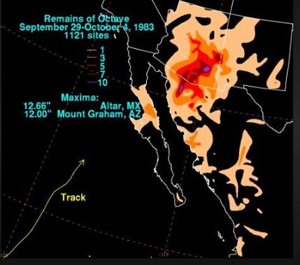
A map showing rainfall totals up to one foot over parts of Arizona from Tropical Storm Octave, Credit- NOAA
The deluge of rain caused many rivers to overflow across Arizona. The towns of Clifton, Duncan, Winkelman Hayden, and Marana suffered catastrophic flood damage.
In Marana, many homes were submerged, forcing residents to be evacuated. Over 700 homes were destroyed in Clifton and about three-quarters of the businesses were destroyed. Over eight hundred houses, mobile homes, and apartments were destroyed while over two thousand others were damaged.
About ten thousand people were temporarily left homeless. Damage in Arizona totaled around 1.3 billion (2024 dollars). Fourteen people drowned and nine hundred and seventy- five were injured.
President Ronald Reagan declared Cochise, Graham, Greenlee, Pima, Santa Cruz, and Yavapai counties a “major disaster area”.
Next door in New Mexico Mexico Octave was responsible for nearly 30 million (2024 dollars) damage in New Mexico. Governor Bruce Babbit declared a major emergency.
Meteorological Factors
Eastern Pacific tropical systems that often turn to the west or northwest (away from Mexico) early in the season sometimes turn to the north and northeast by late September and October.
The reason for this is connected to the jet stream that generally dips southward in the fall and can influence the movement of tropical systems by turning them toward the U.S.

Upper-level atmospheric map (500 mb) valid 7 am September 29, 1983, shows an upper-level low west of California steering moisture from Tropical Storm Octave into the southwestern U.S. Credit – NOAA Central Library- Daily Weather Maps.
Octave was a weakening tropical storm off the coast of Mexico, but there was an unusual trough of low pressure aloft, off the southern coast of California. The upper-level low steered Octave’s moisture right into Arizona and parts of New Mexico This “funneling” effect kept streams of tropical moisture flowing into areas that were already susceptible to flooding.
As a result, cities like Tucson suffered extensive flooding and property damage.

