

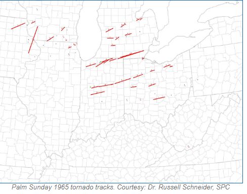
April is a month that has featured numerous tornado outbreaks in the U.S. Palm Sunday mainly occurs in April and that name has been associated with a few tornado outbreaks over the years. The ‘Palm Sunday Tornadoes” of 1965 were especially notable since the event impacted many states and was destructive and deadly.
Just for reference, the table below was the method of categorizing tornadoes at that time (original Fujita Scale).
Meteorological Conditions – April 11, 1965
Meteorologists knew this would be a significant severe weather day even if they weren’t aware just how impactful it would be. At 7 a.m. an area of low pressure continued to intensify over the northern Great Plains and was moving eastward. A strong flow of warm, moist air rushed from the Gulf of Mexico while cold air was streaming down behind a cold front that extended southwest of the low and into the Rockies. The warm front extended eastward to Illinois and Indiana. A strong jet stream aloft stretched from the Pacific Coast to New England and it went right over the northern Plains and Great Lakes to aid in intensifying thunderstorms.
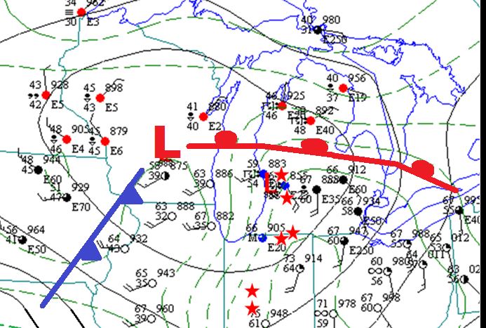
A late-day surface weather map from April 11, 1965, showing low pressure and its attending fronts. NWS-Public Domain
At that time, a Severe Local Storms unit (SELS) issued a statement indicating that tornadoes were possible from northeast Missouri Illinois, and Indiana.
In those days, there weren’t tornado watches like we have now but SELS issued a tornado forecast from northern Illinois to extreme southern Wisconsin. That forecast was issued at 1 p.m. but there had already been two tornado touchdowns at 12:45 in Iowa. One touched down and intensified rapidly into an (F4) damaging over 20 farms. One man near Lowden, Iowa was stuck by debris and died about a month later.
Trail of Destruction Begins
(Illinois and Wisconsin)
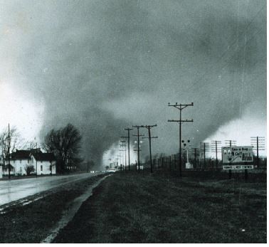
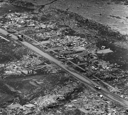
As the day moved past 3 p.m. the tornadoes had their sights set on Illinois and Wisconsin. around 3:20 pm a tornado touched down west of Jefferson, Wisconsin, and headed to the northeast through mainly uninhabited locations. As it reached Route 16 it flung cars off of the road and crushed three people to death. The tornado then demolished a house. Meanwhile, another tornado formed in McHenry County, Illinois and it continued to destroy the southwest area of Crystal Lake. It then came across the southern side of town and destroyed several subdivisions!
It tore apart the Lake Plaza Shopping Center In the Colby’s Home Estates, 155 homes were struck and 45 were demolished.
Unfortunately, equipment like Doppler Radar and the methods of communication were primitive compared to what we have today. The U.S. Weather Bureau in Chicago issued a tornado warning for the Crystal Lake area but the tornado struck within two minutes of that warning!
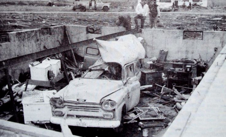
A tornado wiped out a house in Crystal Lake, Illinois on April 11, 1965, Both residents of the house were killed. NWS Photo – Public Domain.
At 4:00 pm a tornado touched down near Saint Charles. This tornado was warned in a more timely manner since it was closer to Chicago (their office had more resources). It did damage twelve homes after crossing Route 30.
Indiana and Michigan
After a brief lull in the action, the severe weather returned with a vengeance! Around 4:35 p.m. a line of severe thunderstorms extended from Wisconsin to central Illinois and was racing eastward. SELS issued a tornado forecast for northern Indiana, northwest Ohio, and southeast Michigan.
Just before 6 p.m., thunderstorms turned surly over northwest Indiana and a tornado touched down in Starke County. The tornado crossed US Route 30 and set its eyes on Koontz Lake. One hundred vacation cottages were severely damaged. Unfortunately, a man in one of the cottages was lifted into the air and his dead body was found about 600 feet away.
The tornado demolished a high school while crossing US Route 31 between La Paz and Lakeville. Next up was Wyatt, Indiana. Some people reported that the sky changed its color from black to green and they sensed that a tornado was approaching. Many fled to their basements to ride out the tornado. The twister tore through Main Street in Wyatt and destroyed twenty homes. There were ten deaths reported from Koontz Lake to Wyatt.
This was another case of a warning issued too late. The South Bend Weather Bureau Office issued a tornado warning a mere two minutes before the tornado struck Koontz Lake. The South Bend. That office was getting their information from Chicago by telephone.
At 6 p.m. The South Bend Office was receiving reports of tornadoes near the towns of Groveton and Argos. The weather observer thre issued a Tornado Warning for Saint Joseph, Marshall, Elkhart, and Kosciusko Counties in Indiana.
At the Elkhart Truth Newspaper, there was a reporter named Paul Huffman who had been receiving weather bulletins all day and h had just heard about the recent warnings. He left his office, got into his car, and headed to Goshen where tornadoes were expected.
He took a camera with him and he happened to take pictures of a tornado that struck Goshen. One was a double funnel. The twin tornadoes then ripped through the town of Dunlap where it destroyed most of the Midway Trailer Park where ten people perished. At the Dunlap Airport, planes were flipped upside down with the wings stripped. One of the wings was found thirty-five miles away!
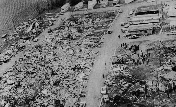
A tornado wiped out a trailer park in Dunlap, Indiana, on April 11, 1965, NWS Photo – Public Domain.
Behind the twin tornadoes, another tornado devastated farms in the Amish community and it ripped through Shore and Rainbow Lake producing close to (F5) damage!
 A rare (for the time) photo of twin (f4) tornadoes near Goshen, Indiana on April 11, 1965. Photo Credit -NWS from Paul Huffman
It was all too much for the U.S. Weather Bureau Offices. At 6:50 p.m. The South Bend Office issued the following statement.
Reports of tornadoes and funnel clouds have become so numerous that it is impossible to keep track of them. Warnings should therefore exist throughout the central northern portion of Indiana. The problems have been intensified by telephones being out in many areas and it is impossible to notify many people.
In western Lenawee County, Michigan, about fifty people were attending Palm Sunday church services at the Manitou Beach Baptist Church. Churchgoers knew about the threat of tornadoes but little did they know about the disaster That was about to happen. Here’s a summary from NWS Northern Indiana.
As the service was nearing its end, the rumbling sound that had been distracting the parishoners grew deafeningly loud. The stained glass windows shattered. People began screaming in their surprise and terror. Plaster rained down on them as mothers grabbed their children and everybody began pushing each other into the aisles. The shrieking wind blew the church doors open, forcing the people inside to bend over to nearly a ninety degree angle as they fought the wind, rain, hail, and debris in order to reach the stairs to the basement. Half of them never made it. The church folded and collapsed upon them, burying over two dozen people in the rubble.
Another tornado came through Manitou Beach but there was nothing much left to destroy. Fortunately, the tornadoes lifted southwest of Detroit.
Continuing to be behind the 8-ball, the Fort Wayne Office issued the following statement.
The Weather Bureau radar at Baer Field shows a strong hook echo about five miles west of Berne Indiana and moving eastward. Residents in the Berne area should take immediate precautions for personal safety for a strong possibility of a tornado in the next 30 to 60 minutes.
The tornado clipped the north side of Berne about six minutes after that statement was sent out. The Fort Wayne office had no idea that an F4 tornado had already been on the ground for twenty-five miles in Grant County and for thirty-five miles before it finally reached Berne. Twenty-nine people had died and nearly nine hundred were injured when the Fort Wayne office sent out that message.
To make matters worse the Fort Wayne Office issued the following statement at 9:20 p.m.
Attention WOMO Please use emergency action notification signal. Marion Indiana reported through the Fort Wayne signal department at 9:07 PM EST that three tornadoes had struck the city of Marion with extensive damage. The Veterans Administration Hospital was one area hit. Request for ambulance assistance has been requested from Muncie and Anderson. The Fort Wayne Weather Bureau places these counties under alert for eastward movement that struck Marion. These counties are Wells Adams Blackford and Jay Counties. Residents in these counties should remain on alert for the next 60 minutes.
Again, I will refer to a summary published by the NWS in Northern Indiana.
The tornadoes Fort Wayne was warning for had actually hit Marion a full hour and twenty minutes earlier. Apparently the Fort Wayne weather observer thought that the report he received from Marion was saying that the tornadoes had just occurred. The Fort Wayne observer then sent a message to the Columbus Ohio weather office stating that a tornado had hit Marion at 9:07pm, and the Columbus weather office then issued its own statement with that same erroneous information. In reality the storm had hit Marion around 8pm. At the time of Fort Wayne's warning, the line of storms on radar was well east of Marion, extending from Paulding and Van Wert counties into Adams and Jay counties.
At 9:30 pm the Fort Wayne office lost power and was out of service for an hour. By the time the office got its electricity back, the storms were well east into Ohio.
Ohio
In northwest Ohio, a severe thunderstorm produced a tornado that struck the northwest section of Toledo. Close to (F5) damage occurred in the Creekside Addition as fifty homes were destroyed! A tornado lifted a bus on the Toledo-Detroit Expressway and it slammed on the highway killing four people. Cars and boats were lifted out of the water near Lake Erie’s western shore and slammed into buildings. There was never a warning issued for that tornado!
A devastating tornado produced (F4) damage on the southwest side of Toledo, Ohio, on April 11, 1965. NWS-Public Domain.
Just past 10 pm, a tornado derailed fifty-three cars of a sixty-eight-unit train in Shelby County, Ohio. Things got even worse later farther to the east. An (F5) tornado killed seven residents of Pittsfield. The destruction of that town was “total” according to the Cleveland Weather Office.
Summary
Here is a list of the tornadoes, with statistics and damage.
| List of reported tornadoes – Sunday, April 11, 1965 | ||||||
|---|---|---|---|---|---|---|
| F# | Location | County | Time (UTC) | Path length | Damage | |
| Iowa | ||||||
| F4 | NE of Tipton | Cedar, Clinton, Jackson | 1855 | 91.5 miles (147.3 km) | 1 death – One person died one month later from their injuries. 25 farms were affected, one of which had every building leveled. Pieces of a farmhouse were carried for over a mile. | |
| F1 | SE of New Hampton | Chickasaw, Fayette, Allamakee | 1915 | 49.9 miles (80.3 km) | ||
| Wisconsin | ||||||
| F1 | SE of Monroe | Green, Rock, Dane | 2000 | 27.1 miles (43.6 km) | 50 homes and 65 businesses destroyed or damaged and 40 were injured. Over 400 cars were damaged or destroyed. | |
| F2 | S of Watertown | Jefferson | 2030 | 14.5 miles (23.3 km) | 3 deaths – Deaths were from occupants of a car that was thrown. 28 others were injured. Structures were destroyed on 20 farms. | |
| F1 | S of Soldiers Grove | Crawford | 2045 | 13.3 miles (21.4 km) | One barn was destroyed. | |
| F1 | W of Lake Geneva | Walworth | 2150 | 1.9 miles (3.1 km) | Homes and structures were damaged near Williams Bay. | |
| F1 | NW of Elkhorn | Walworth | 2155 | 1 mile (1.6 km) | One barn was destroyed. | |
| F1 | W of Tomah | Monroe | 2214 | 2 miles (3.2 km) | Several farm buildings were destroyed. | |
| Illinois | ||||||
| F4 | Crystal Lake | McHenry, Lake | 2120 | 9.1 miles (14.6 km) | 6 deaths – Destroyed large sections of the town including a shopping mall. 45 homes were destroyed and 110 were damaged in a single subdivision. A few of the homes were completely swept away. Damage estimates were at about $1.5 million. | |
| F2 | N of Gurnee | Lake | 2150 | 4.5 miles (7.2 km) | Several homes were damaged and two planes flipped at Waukegan Memorial Airport. Falling trees damaged some homes and two others lost their roofs. | |
| F1 | Geneva | Kane | 2200 | 0.3 miles (0.5 km) | About a dozen homes were heavily damaged | |
| F1 | Zion | Lake | 2204 | 0.5 miles (0.8 km) | ||
| Indiana | ||||||
| F3 | NE of Knox to S of South Bend | Starke, Marshall, St. Joseph, Elkhart | 2245 | 35.6 miles (57.3 km) | 10 deaths – 30 cottages were destroyed and 70 others were damaged along Koontz Lake. 26 homes, one church and one high school were also destroyed. There were 82 people injured. Severe damage took place near La Paz and in the town of Wyatt. | |
| F3 | S of Crown Point to SE of Laporte | Porter, Laporte | 2310 | 33.1 miles (53.3 km) | Several homes and barns were destroyed and 4 people were injured. | |
| F4 | W of Wakarusa to NW of Middlebury | Elkhart | 2315 | 21.2 miles (34.1 km) | 14 deaths – Tornado first touched down and caused severe damage in the Wakarusa area. Destroyed the Midway Trailer Park in Dunlap and numerous other homes in the Middlebury area. Some homes were completely swept away. Was photographed as a double tornado. A Goshen airplane wing was found 35 miles away in Centerville, Michigan. 1st of 2 tornadoes to hit the town of Dunlap. May have been an F5. | |
| F4 | NE of Goshen to W of Orland | Elkhart, LaGrange | 2340 | 21.6 miles (34.8 km) | 5 deaths – Dozens of homes were demolished in the Rainbow Lake and Shore areas south of Shipshewana, several of which were completely swept away. Some sources list 17 fatalities. May have been an F5. | |
| F4 | Manitou Beach-Devils Lake, Michigan (1st tornado) | Steuben, Branch, Hillsdale, Lenawee, Monroe, Washtenaw | 0000 | 90.3 miles (145.3 km) | 23 deaths – Starting just south of the Indiana-Michigan state line, this massive tornado caused extensive damage to the Manitou Beach region and areas southwest of Detroit. Many structures were destroyed, including a row of homes that were completely swept away and thrown into Coldwater Lake. First of two violent tornadoes to affect the same portion of Lower Michigan. Damage from the two tornadoes was difficult to separate. Damage path in Lenawee County extended up to 4 miles wide. | |
| F4 | SE of Lafayette to W of Russiaville | Tippecanoe, Clinton | 0007 | 21.8 miles (35.1 km) | Several homes and other buildings were destroyed or damaged. Homes were completely leveled in Mulberry and Moran. | |
| F4 | SE of South Bend to NE of Shipshewana | St. Joseph, Elkhart, LaGrange | 0010 | 37 miles (59.5 km) | 36 deaths – 2nd violent tornado to strike the town of Dunlap in just over an hour. The Sunnyside subdivision was completely destroyed, with many homes swept away. The Kingston Heights subdivision was also devastated. 6 of the victims were killed when the tornado demolished a truck stop. Affected rescue efforts after the first tornado. Also was witnessed as a double tornado. Was initially rated an F5 but downgraded to an F4. | |
| F4 | Russiaville to SE of Marion and Greentown | Clinton, Howard, Grant | 0020 | 48 miles (77.2 km) | 25 deaths – Large sections of Russiaville, Greentown, southern Kokomo and Alto were destroyed. 90% of the structures in Russiaville were damaged or destroyed. The tornado was up to a mile wide when it struck Alto and Kokomo, where hundreds of homes were destroyed. Many homes were destroyed and swept away as the tornado struck Greentown, and multiple fatalities occurred in vehicles in that area. A hospital had its roof torn off south of Marion, and a shopping center was destroyed. Several homes were destroyed in Marion as well. Over 800 people were injured. | |
| F4 | SE of Crawfordsville to Arcadia | Montgomery, Boone, Hamilton | 0050 | 45.7 miles (73.5 km) | 28 deaths – 80 homes were destroyed and over 100 people were injured between Crawfordsville and Arcadia. Some of the most severe damage occurred near the towns of Lebanon and Sheridan. Tornado was up to a mile wide and threw cars over 100 yards. May have been an F5. | |
| F4 | W of Montpellier to N of Spencerville, OH | Blackford, Wells, Adams, Mercer, Van Wert | 0110 | 52.5 miles (84.5 km) | 4 deaths – F4 damage was observed in Keystone in Wells County. Severe damage also occurred in the Berne area, where a bowling alley, a lumber yard, and a grocery store were destroyed. Tornado crossed into Ohio where it destroyed five homes and damaged five others. | |
| Michigan | ||||||
| F4 | N of Grand Rapids | Ottawa, Kent | 2254 | 20.6 miles (33.2 km) | 5 deaths – 34 homes were destroyed and nearly 200 others damaged near the northern suburbs of Comstock Park and Alpine. Nearly 150 were injured and damage amounts were estimated at almost $15 million. | |
| F1 | N of Middleville | Allegan, Barry | 0005 | 19.5 miles (31.4 km) | 1 death – A trailer and 5 homes were destroyed while 25 others were damaged. | |
| F3 | NE of Kalamazoo | Kalamazoo | 0030 | 14.2 miles (22.9 km) | 4 homes were destroyed and 22 others damaged. 17 people were injured. | |
| F3 | Hastings | Barry | 0040 | 14.1 miles (22.7 km) | 15 homes were damaged and barns and garages were leveled. | |
| F4 | Manitou Beach-Devils Lake, Michigan (2nd tornado) | Branch, Hillsdale, Lenawee, Monroe, Washtenaw | 0040 | 80.5 miles (129.6 km) | 21 deaths – Second tornado to hit the same areas 30 minutes after being affected by the first tornado. Tornado leveled what was left standing from the first tornado. Total damage estimates from the two tornadoes were $32 million. Over 550 homes, 2 churches, a dance hall, and 100 cottages were destroyed in total. The two tornadoes also caused major damage in and around the towns of Onsted and Milan. | |
| F4 | N of Lansing | Clinton, Shiawassee | 0115 | 21 miles (33.8 km) | 1 death – Several homes were severely damaged or destroyed, one of which was swept away. | |
| F2 | W of Ithaca | Montcalm, Gratiot | 0125 | 15.1 miles (24.3 km) | Several farm buildings and livestocks were destroyed. One home was nearly leveled. | |
| F2 | Alma (1st tornado) | Gratiot | 0130 | 0.1 miles (0.16 km) | One of three tornadoes to strike the area where it caused damage to several buildings including the library, which had its roof torn off. A telephone repair facility was destroyed as well. | |
| F2 | Alma (2nd tornado) | Gratiot | 0130 | 0.5 miles (0.8 km) | ||
| F2 | E of Alma | Gratiot | 0130 | 1 mile (1.6 km) | ||
| F2 | SE of Bay City | Bay | 0150 | 9.9 miles (15.9 km) | Tornado tore the roof off homes and an auto dealership. Trailers and barns were destroyed as well. | |
| F2 | SW of Unionville | Tuscola | 0200 | 9 miles (14.5 km) | Damage to a firehall and lumberyard. Barns were also destroyed. | |
| Ohio | ||||||
| F4 | Northern Toledo | Lucas, Monroe | 0230 | 5.6 miles (9.0 km) | 18 deaths – Numerous homes in the northern suburbs of Toledo were completely destroyed, several of which were completely swept away. 5 people were killed when the tornado picked up a bus and slammed it upside down onto the pavement. Boats and cars were thrown onto and into buildings. A paint factory and department store were destroyed as well. Two people were killed on the Lost Peninsula in Michigan. There were reports of twin tornadoes during the event. Damage amounts were estimated at $25 million. | |
| F4 | N of Lima | Allen, Hancock | 0230 | 32.5 miles (52.3 km) | 13 deaths – Numerous homes and farms were destroyed along the track, some of which were completely obliterated. | |
| F4 | N of Sidney | Shelby | 0300 | 18.4 miles (29.6 km) | 3 deaths – Affected Anna, Swanders and Maplewood where 25 homes were destroyed and 20 others heavily damaged. Several train cars were derailed, and an automobile was carried for 200 yards. | |
| F3 | SE of Tiffin | Seneca | 0315 | 15 miles (24.1 km) | 4 deaths – Struck Rockaway, where 4 homes were leveled and three others were damaged. | |
| F4 | S of Oberlin to Strongsville | Lorain, Cuyahoga | 0405 | 22 miles (35.4 km) | 18 deaths – Extensive damage to Pittsfield and Strongsville. Pittsfield was nearly destroyed and 6 homes were completely swept away there. Vehicles were thrown hundreds of feet and mangled. The tornado then struck Grafton at F2 strength, damaging homes, and a car dealership before re-intensifying and striking the north side of Strongsville. In Strongsville 18 homes were leveled, some of which were cleanly swept from their foundations. 50 others were badly damaged in town. Damage amounts were estimated at $5 million. Was listed as an F5 according to meteorologist and tornado historian Thomas Grazulis. Also witnessed as a double tornado. | |
| F1 | S of Eaton | Preble | 0415 | 0.1 miles (0.16 km) | ||
| F1 | Brunswick | Medina | 0430 | 8.2 miles (13.2 km) | One home was destroyed and several others were damaged in Brunswick. | |
| F2 | N of Delaware | Union, Delaware, Morrow | 0430 | 22.2 miles (35.7 km) | 4 deaths – Tornado struck the towns of Radnor and Westfield. 4 were killed in Radnor and 22 were injured in Westfield. 25 homes were destroyed. | |
| F1 | S of Cedarville | Greene | 0450 | 0.1 miles (0.16 km) | ||
| F1 | Ashville to Somerset | Pickaway, Fairfield,Perry | 0530 | 38.4 miles (61.8 km) | Several farm buildings were destroyed along the path. A dozen trailers were destroyed at a sales lot in Dumontville. | |
| Sources:Tornado History Project Tornado Data for April 11, 1965, Tornado History Project Tornado Data for April 12, 1965, NCDC 22508 NWS Detroit Storm Data | ||||||
April 12 event
| List of reported tornadoes – Monday, April 12, 1965 | ||||||
|---|---|---|---|---|---|---|
| Georgia | ||||||
| F1 | SW of Grassdale | Bartow | 0950 | 2 miles (3.2 km) | ||
| West Virginia | ||||||
| F2 | N of Princeton | Mercer | 1130 | 0.1 miles (0.16 km) | ||
| Sources:Tornado History Project Tornado Data for April 12, 1965 | ||||||
This devastating event resulted in 271 fatalities and over 3400 injuries! Total Damage was an incredible 600 million dollars (nearly 2 billion in 2024).
The event led to groundbreaking tornado research, initiated by Dr. Ted Fujita from the University of Chicago. A storm survey National Weather Service Storm Survey, formulated and eventually instituted a list of recommendations to revamp the entire system of tornado identification (including radar) and communication (both internally and externally

