

If there was a Hall of Fame for non-tropical storms, there is one that would be voted in on the first ballot. That storm had everything to an extreme. Hurricane-force winds and storm surges, heavy snow and blizzard conditions in areas that don’t see snow very often, severe thunderstorms with tornadoes and heavy rain. Plus, it set many low-pressure records (for non-tropical storms) in several locations across the eastern U.S. This event became commonly known as “Superstorm” or “The Storm of the Century”).
The Weather Channel Forecast Center – Monday, March 8th, 1993
This was one of the most notorious storms that we ever had to cover at The Weather Channel, Back then, I was a supervisor in the On-Camera Meteorology Department, In addition to supervisory duties, I also appeared on camera when needed. I came into work that morning and when I passed the area where the On-Camera staff prepare their shows, one of the On-Camera Meteorologists, Mark Mancuso, motioned for me to come over.
Mark handed me a computer model (upper-level) forecast for the coming weekend. What I saw was shocking and something that I had never seen before. it showed a very deep trough of low pressure (dip in the jet stream) that extended from the higher latitudes down to the Gulf of Mexico. This would allow some extremely cold air to surge to the Gulf Of Mexico and a significant storm would be triggered.
Back then, the longer-range computer models were hit-and-miss so I was naturally skeptical. I remember saying to him “If this verifies, it will be one of the greatest storms that we have ever seen”. You can only imagine a room full of meteorologists looking at all of the models.
I don’t have any copies of the computer models, but here is the actual 500 millibar chart for 7 a.m. March 13, 1993, from NOAA. Notice the extremely deep trough down to the Gulf of Mexico. The models verified pretty well in this case.

The computer models didn’t back off in the days ahead, so there was ample warning of an extreme storm that would occur. There were some aspects of this “beast” that wasn’t anticipated, however.
Friday, March 12th
A storm system did form in the western Gulf of Mexico and it rapidly intensified. Wind gusts of 60 to 70 mph were recorded at some oil rigs.
Even in the Gulf of Mexico, the storm’s pressure was lower than you would usually see with an East Coast storm that would be up off the coastal Carolinas.
With temperatures near freezing, snow spread rapidly northward from southern Mississippi through northwest Alabama, to central and eastern Tennessee, southwest Virginia, and southern West Virginia.
Farther east, a cold rain began to fall in most of Georgia through the western Carolinas. Toward midnight, a squall line of intense thunderstorms with wind gusts over 70 mph moved from the Gulf Coast into Florida.
Eleven confirmed tornadoes were spawned by the squall line (derecho) in Florida and some produced considerable damage. One Ef-2 tornado produced damage at the airport in Ocala. Off the southwest coast of Florida, the Dry Tortugas experienced a wind gust of 109 mph.
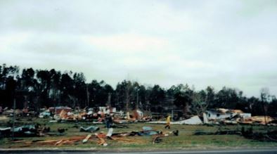
A photo shows tornado damage near Tampa, Florida from a tornado associated with “Superstorm” on March 13, 1993. Credit” NWS Tampa.
Saturday, March 13th
Around midnight, a cold rain changed to snow as far south as Mobile, Alabama. and it was snowing in the western Florida Panhandle. The rain changed to heavy snow in northwest Georgia and in the mountains of Tennessee, North Carolina, and western Virginia. Around Atlanta, the rain finally changed to snow before dawn.

An image shows snow in the western Florida Panhandle resulting from a “Superstorm” on March 13, 1993.Credit: YouTube.
Some locations experienced blizzard conditions as winds exceeded 40 mph. The mercury plunged into the teens in Atlanta and the 20s down to the Gulf Coast. Roads became impassable with ice and snow. Power outages were widespread across the southeastern U.S.
Snow began to fall in Washington, D.C., Baltimore, Philadelphia, and New York City. Intense low pressure moved from south central Georgia to the Carolinas and it continued to intensify.
Winds off the west coast of Florida became very strong and persistent. The storm surge rose to over twelve feet (incredible for a non-tropical storm) in counties north of Tampa. Some residents were forced to climb up to rooftops to avoid drowning.

A map shows storm surge (feet) for Florida locations that resulted from the March 1993 “Superstorm” Map Credit: NWS Tampa.
Snow became heavy from Atlanta and up through the Appalachian Mountains. The snow was accompanied by plenty of lightning and thunder.

A photo shows cars covered with snow in a parking lot near Atlanta, Georgia, following “Superstorm” on March 13, 1993. Credit” NWS.
Light snow began to fall in the southern tier of New York state. and the snow becomes heavy in locations like Pittsburgh, Pennsylvania.
The snow tapered off across the South by early afternoon. Since the storm track was so close to the Baltimore-Washington, DC. area, the snow changed to rain after a light accumulation as milder Atlantic air was pulled inland.
Wind gusts of 60 to 90 mph were reported from the Carolinas to New Jersey. This produced considerable damage to docks and piers in the Carolinas. Myrtle Beach, South Carolina, reported a wind gust of 90 mph.
During the afternoon hours, the storm set numerous low barometric pressure records from North Carolina to Massachusetts. These records indicate that the Blizzard of 1993 was a more intense storm than that of 1888. After an accumulation of around a foot of snow, the snow turned to rain in New York City, Long Island, and southern New England. Boston also picked up over a foot of snow.
Blizzard conditions continued in western Pennsylvania, central New York state, and northern New England. The rapid movement of the storm spared the Middle Atlantic region from additional coastal flooding.
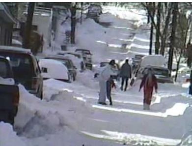
An image shows a street clogged with snow in Pittsburgh, Pennsylvania following “Superstorm” on March 14, 1993. Credit: YouTube.
Sunday, March 14th
The storm’s center of low pressure moved into Maine by morning. Snow slowly tapered off in Pennsylvania and New York state. Pockets of heavy snow continued to fall in Syracuse, New York, with enhancement from Lake Ontario. The snow was accompanied by wind exceeding 40 mph.

An image shows “whiteout” conditions in Syracuse, New York resulting from a combination of strong wind and lake-enhanced snow on March 14, 1993. Credit- YouTube.
NWS Storm Summary
On Friday, March 12, a strong complex of thunderstorms had developed in the northwestern Gulf of Mexico and then merged with a narrow band of snow and rain that was moving in from the western United States.
By that evening the two features had merged with the strong jet stream. The system developed into a very potent storm which began tracking across the Gulf toward Florida. The United States Coast Guard reported that the sea conditions in the Gulf were unbelievable. According to the Petty Officer Rob Wyman, he told the Washington Post that the sea looked like a big washing machine.
There were huge waves, spray, and hail. Some of the sea buoys had sustained hurricane-force winds. The waves were so powerful that a 200-foot freighter sunk 70 miles off Fort Myers, Florida. By the time the storm had passed, the Coast Guard had deployed more than a hundred planes, helicopters, and boats. The deployment had rescued 235 as well as more than a hundred boats in the Gulf of Mexico.
As the storm blew ashore, it created 11 tornadoes over Florida that had overturned mobile homes and launched trees and other debris. Between 4:00 and 5:30 am on Saturday, a storm surge as high as 12 feet in some places came ashore.
The storm system caused blizzard conditions over much of the Eastern Seaboard. It brought thundersnow from Texas through Pennsylvania with some whiteout conditions.
The storm was responsible for 300 deaths and power outages to over 10 million customers. Many of the deaths were due to heart attacks from shoveling snow. The storm system directly affected over 130 million people. Every airport along the East Coast was closed for some time during the event.
Airports from Halifax, Nova Scotia to Atlanta, Georgia were closed for some time because of the storm. A record low pressure of 28.35 inches of mercury (960 millibars) was recorded in New England. Such low readings are usually associated with Category 2 or 3 intensity hurricanes on the Saffir-Simpson Scale. Record low temperatures were recorded in much of the South behind the storm.
With the assessment of this storm system, 26 states and an estimated 100 million had been affected. This had an impact on travel, hundreds of fatalities, and billions of dollars of damage and economic losses. As far as weather historical records, there has not been a winter storm to match the effects of this system.
In the South, where public works facilities in most areas generally have no reason to be prepared for snow removal, the storm is remembered because it resulted in a complete shutdown of some regions for three days.
Cities that usually receive little snowfall such as Chattanooga, Tennessee, received nearly two feet of snow. This has caused some cities to adopt an emergency winter-weather plan for the future. Birmingham recorded a record low temperature of 2°F behind the storm. Syracuse, New York received 43 inches from the storm. That was a record for a snow event in Syracuse, eclipsing the famous” Blizzard of ’66”. The temperature dropped to 11 degrees below zero after the storm.

A photo shows all the snow that fell near Huntsville, Alabama from “Superstorm” on March 13, 1993. Credit-Public Domain.
Two feet of snow fell in Hartford, Connecticut. The weight of the snow collapsed many factory roofs in the South. Snowdrifts on the windward side of buildings caused a few decks with substandard anchors to fall from homes.
The heaviest snowfall was at Newfound Gap, where US Highway 441 crosses the Tennessee and North Carolina border, recorded five feet of snow, and drifts up to 14 feet were observed at Mount Mitchell.
There were wind gusts there as high as 110 mph according to NCDC. Power outages, on average, lasted for one to two weeks all over the East. The blizzard from this storm caused a total of $6.6 billion of damage. Nearly 60,000 lightning strikes were recorded as the storm swept over the country, for a total of seventy-two hours, and many may remember their local news organizations touting the term “thundersnow”.
Thousands of people were isolated by record snowfalls, especially in the Georgia, North Carolina, and Virginia mountains. Over 200 hikers were rescued from the North Carolina and Tennessee mountains.
Curfews were enforced in many counties and cities as ‘states of emergency’ were declared. The National Guard was deployed in many areas to protect lives and property. Generally, all interstate highways from Atlanta northward were closed.
This beast brought hurricane-force winds up the Eastern Seaboard. The lowest pressure dropped to 960 millibars.

A map shows snowfall totals from the 1993 March “Superstorm” Map Credit: weather.gov.
Notice that this storm was rated as a Category 5 winter storm on the NESIS Scale (Extreme). The Northeast Snowfall Impact Scale (NESIS) developed by Paul Kocin and Louis Uccellini of the National Weather Service (Kocin and Uccellini, 2004) characterizes and ranks high-impact Northeast snowstorms.
On the winter aspect of this storm, areas as far south as central Alabama and Georgia received 4 to 6 inches of snow. Some areas received heavier amounts like 12 inches in Birmingham Alabama with some reports of 16 inches area the metro area. The Florida Panhandle had some 2-inch amounts, which were accompanied by hurricane-force winds and record-low barometric pressures.
Odds and Ends
Even though Atlanta only officially reported 4.5 inches of snow, it was closer to six inches of snow in Midtown and up to 9 inches of snow in the northern suburbs. With winds gusting to over 40 mph, many in the area lost power.
I stayed up Friday night and I vowed that I wouldn’t get to bed until the rain (and there was plenty of it) changed to snow. Each half-hour I would peek out the window and it was still raining around 4 a.m. The rain FINALLY changed to snow in Kennesaw, Georgia where lived. I dozed off to sleep but thunder woke me up.
I looked out the window and all I could see was white with heavy snow falling and strong winds whipping it around. This was around 6 a.m. I took a real good look because this was north Georgia after all and I didn’t think that I would ever see anything like this again.

Surface weather map showing “Superstorm” in the Southeast U.S. on March 13, 1993. a Credit: NWS-Wilmington, NC.
Later on, I went outside as the snow stopped. The wind was bitter and strong and the temperature had fallen to the low teens.
Here is a table (from NWS) of the maximum wind gusts observed with “Superstorm”.

Although the computer models generally did a good job of forecasting this storm. There were slight differences in the forecast storm track and that made a big difference. tracking just inland from the coast allowed snow to change to rain across coastal areas from the Mid-Atlantic to southern New England.
The severe weather in Florida was expected, but there were more tornadoes than anticipated and the storm surge was also missed (although meteorologists were more focused on other aspects of the storm.) Fortunately, the maximum storm surge occurred in a low-population area.
The snow was widespread. It has been estimated that this storm produced more snow than any other storm had in the eastern U.S. Here are some selected location snow totals (from NWS).
 Later on, I went outside as the snow stopped. The wind was bitter and strong and the temperature had fallen to the low teens. Everything had frozen solid. It was impossible to get around and Atlanta was shut down for five days.
Saturday was my first of a scheduled three days off from work so I didn’t have to go back to work until the following Tuesday. The commute was rough, but I made it there and back for two days.
Birmingham and Chattanooga received more snow than we did. Cars were stranded on Interstates 20, 85 and 75. Many college students who were on their way to Florida were stopped cold on the roadways. Food was distributed to them and hotels opened up rooms for these shocked and stranded motorists. Many of them didn’t even bring a sweater or a jacket with them.
The Appalachians were snowbound. Tennessee and North Carolina had to call in the National Guard to provide supplies to residents. This was true in cities like Asheville and Knoxville.
According to the NWS, there were around 60,000 cloud-to-ground lightning strikes associated with this storm.
Here is a table (from NWS) of the maximum wind gusts observed with “Superstorm”
The snow was widespread. It has been estimated that this storm produced more snow than any other storm had in the eastern U.S. Here are some selected location snow totals (from NWS).
Elsewhere, the storm also affected the Yucatan Peninsula of Mexico with thunderstorms. A wind gust of 100 mph was recorded in Havana, Cuba.
It could be a long time before we see anything like this again!


