


It’s that time of year again when we try to figure out what to expect for the upcoming winter. A seasonal forecast at any time of year is always tricky. Still, the winter forecast is the most difficult because you have far more factors to consider than just tropical forcing. When creating a seasonal forecast for the warm season (Spring and Summer), your primary forcing mechanisms are from the tropical regions so that you can focus on the state of ENSO. However, in the cold season months, you must consider various factors outside of the tropical regime like the state of the stratosphere, the transport mechanisms between the tropospheric mid-latitudes and the stratospheric high latitudes, movement of stratospheric winds, and how all of these factors interact with each other.
This year, in the Winter forecast, we’ll split the forcing mechanisms into two main areas, Tropical and Non-Tropical, which can be read in the Premium Version. Tropical forcing mechanisms will include my thoughts on El Niño, the nature of the MJO, sea surface temperature anomalies, and latent heat release factors on the Subtropical and Polar jet streams. Non-tropical will include the state of the cryosphere, stratospheric temperatures, and wind and how these factors influence high-latitude blocking. The final section will be a detailed breakdown of the themes for this winter, what can be expected, and what factors to watch out for to change the seasonal forecast.
THE WINTER FORECAST OF 2023/2024
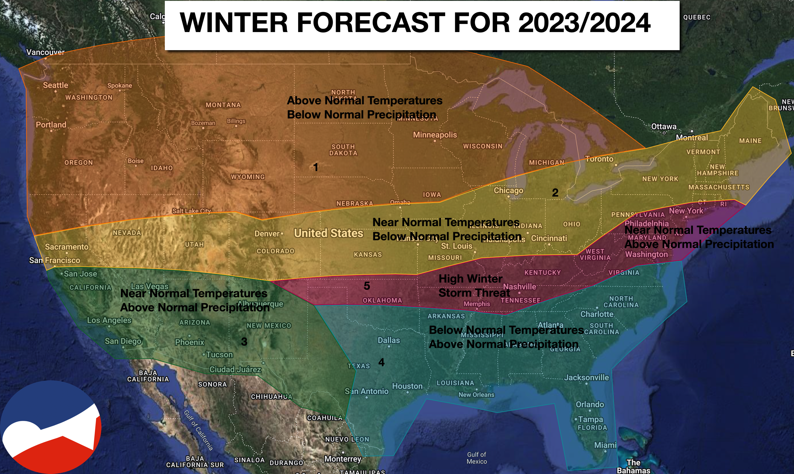 This winter forecast is a developed analysis of a combination of tropical and non-tropical forcing parameters on the 500 MB pattern through the winter. Most El Niño influenced winter weather patterns feature the warmest conditions of the winter in December and the stormiest and coldest conditions in January and February. Many El Niño winters typically feature winter weather threats into early March if high-latitude blocking is favorable. For the national forecast, we’ll break down the forecast into five regions.
REGION ONE:
In this region, you can create two sub-regions. Over the Pacific Northwest and Rockies, an upper-level ridge will be in place, keeping temperatures above normal and precipitation below normal through much of the winter. Sub-region two is over the Northern Plains, the western Great Lakes, and the central Great Lakes, where Polar and Arctic air masses will pass through and moderate at a rapid pace. The storm track will remain south of these locations, keeping precipitation throughout the winter below normal.
REGION TWO:
In this region, the primary storm track from the Subtropical jet stream will remain south of these locations, thus the below-normal precipitation expectation. This stripe of dry conditions will especially stand out in the Ohio River Valley, eastern Great Lakes, and New England, where significant winter storms will be found just southeast of these locations. Temperatures will average near normal, with the warmest conditions in December and the coldest conditions in February, which will average the three months to near average by +1 to -1 degrees Fahrenheit.
REGION THREE:
Southern California and the Desert Southwest will be under the influence of a strong Subtropical jet stream that will feature above-normal precipitation through the winter. Temperatures will average near normal under the influence of a constant Pacific air mass. Significant flooding events will be possible through the winter.
REGION FOUR:
With a strong Subtropical jet stream and some influence from the Polar jet stream from time to time, precipitation will be above average, and temperatures will be below normal through the winter. While Polar air masses are expected to be modified and shallow this winter, the overall theme will feature below-average temperatures of around -0.5 to -1.5 Fahrenheit through the winter. Heavy rainfall events will be a high threat along the Gulf Coast, along with significant severe thunderstorm events.
REGION FIVE:
In this region, the potential for interaction between the Polar and Subtropical jet streams will be highest. Much like other regions, the warmest temperatures for the winter will be in December and the coldest in February, with the highest threat of winter storms from mid-January through early March. While there is a temptation to call for above-normal snowfall in these locations, the state of the Polar and Arctic air masses, as described, would suggest a mix of snow, ice, and rain storms this winter that could lead to some locations with well-above-average snowfall and others bel0w-normal based on the impacts of one or two winter storms. The locations in Region Five will feature the highest volatility in temperatures and precipitation type.
NORTHERN MID-ATLANTIC DETAILS
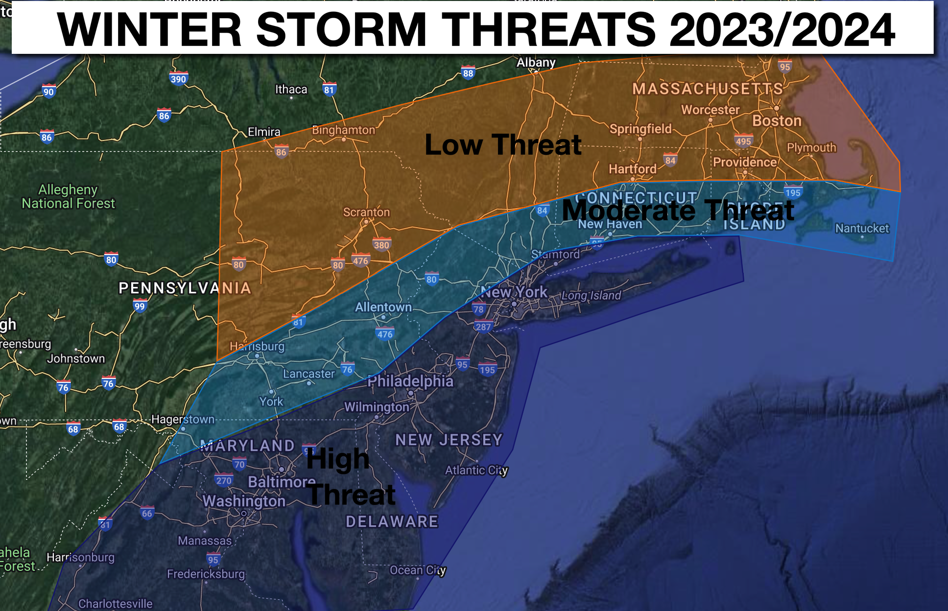 Every winter, I get the same question: will it snow and snow often? The answer to that question is always far more complicated than the yes or no answer that everyone wants, and that is especially true this year. The map above provides my idea of the best potential to be impacted by significant winter storms this winter based on the idea that this winter will feature several series of coastal storms via either Miller B or Miller A storm development. Miller A storms are low-pressure systems that develop along the Gulf Coast and track toward the Mid-Atlantic. Meanwhile, Miller B storms typically feature low-pressure systems in the Ohio River Valley that redevelop off the Mid-Atlantic coast. So, let’s break down my expectations.
TELECONNECTION FACTORS AND STORM TRACKS:
As is typical with all winters, the teleconnections will provide a clue in what to expect at periods throughout the winter. The following are general expectations for the winter.
NEGATIVE EPO/POSITIVE PNA/WEST-BASED NEGATIVE NAO: This configuration will feature the best potential for winter storms that could feature significant wintry precipitation. In this configuration, the storm track is over the coastal waters, and whatever cold air is available will likely remain over the coastal plain. This pattern will feature storms that either track along the coast from the Gulf Coast towards the Mid-Atlantic coastal waters or redevelop from the Ohio River Valley to the Mid-Atlantic coast.
NEGATIVE EPO/POSITIVE PNA/EAST-BASED NEGATIVE NAO: This pattern is also favorable for winter storm development, but due to the blocking in the Atlantic, it shifted further east; many low-pressure systems are able to track further into the western Atlantic and just southeast of the coastal plain of the Northern Mid-Atlantic
POSITIVE EPO/NEUTRAL PNA/NEGATIVE NAO (EAST OR WEST BASED): This pattern features a progressive weather pattern where the bulk of the moisture transport and storm potential is associated with the Subtropical jet stream. However, because of the block in the northern Atlantic, the precipitation shield can reach the southern Mid-Atlantic and parts of the northern Mid-Atlantic, but mostly a progressive suppressed storm track. This could feature a winter precipitation event for locations southeast of Philadelphia.
POSITIVE EPO/NEGATIVE PNA/POSITIVE NAO: This pattern will be the least frequent and feature a significant influence from Pacific air masses. The Polar and Subtropical jet streams remain separate and progressive.
AIR MASSES AND PRECIPITATION TYPES:
As discussed in the technical Premium Discussion above, I am not overly impressed with the Polar and Arctic air masses that will be present this winter. As such, I think we’ll experience a lot of marginal Polar air masses with the winter storms or when 500 MB upper-level low-pressure systems rapidly intensify. The adiabatic process of rapidly falling 500 MB height could be a theme where Polar air masses cool just enough to feature heavy wintery precipitation events. Many of the precipitation events will likely feature low snow ratio events, which would support above average precipitation events but near to bel0w-normal snowfall amounts due to these ratios.
THE ONE-STORM IMPACT: This type of winter pattern is a perfect environment for the one or two winter storm impacts that could skew snowfall totals for the region. This type of El Niño forcing and high latitude blocking potential will be capable of producing powerful Nor’Easter winter storm potential in mid-January through February. I would not be surprised if this winter is made by just one or two impressive winter storms.
MONTHLY BREAK DOWN
DECEMBER: Temperatures will average near to slightly above normal with a range of upper 20s over the interior to the mid-30s along the coast for lows and upper 30s over the interior and upper 40s along the coast for highs. Liquid precipitation will range from 2″ over the interior to 5″ along the coast. This period will be least likely to feature winter storms. Snowfall potential will range from 5″ of the interior and 1″ along the coast.
WHITE CHRISTMAS POTENTIAL: This potential is naturally low at around a 10% chance. This year, it will likely be around 5% over the interior and 1% on the coast.
JANUARY: Temperatures will average near normal with a range of upper 10s over the interior to the mid-20s along the coast and lower 30s over the interior to the lower 40s along the coast for highs. Liquid precipitation will range from 2″ over the interior to 5″ along the coast. This period will feature an increased potential of winter storms, especially after mid-month. Snowfall potential will range from 5″ over the interior to 15″ along the coast.
FEBRUARY: Temperatures will average near to below normal with a range from the lower 10s over the interior to the mid-20s along the coast for lows and lower 30s over the interior, and upper 30s along the coast for highs. Liquid precipitation will range from 2″ over the interior to 5″ along the coast. This period will feature the best potential for winter storms in the region, with 10″ over the interior and 20″ along the coast.
OVERALL SNOWFALL EXPECTATION:
Poconos/Catskills/Hudson River Valley/Hudson Highlands: 20″-30″ (Average: 40″-70″)
I-95 Corridor: 30″-50″ (Average: 20″-40″)
NJ Coast/Long Island: 20″-40″ (Average: 15″-30″)
WHAT CAN GO WRONG:
Finally, as with every Winter forecast, I want to share what can fundamentally change the forecast from my current expectations.
- The first potential deviation in the forecast is that the snow growth and depth over Siberia and Canada significantly increase above current expectations. This factor would increase the potential for disruption of the Polar Vortex and also enhance deeper and stronger Polar and Arctic air masses this year. This factor would increase the potential for higher snowfall ratios with storms and increase the potential of sustained high-latitude blocking.
- The second potential deviation in the forecast is that the Polar Vortex becomes extremely strong and overcomes any influence from the negative QBO phase. A robust Polar Vortex would create a positive EPO/NAO combination and, thus, a very mild and dry weather pattern for much of the United States aside from the Gulf Coast.
- All the tropical forcing shifts to the east. This outcome would displace all lifting parameters to the east and thus place the storm track over the western Atlantic rather than near the coastal waters. This type of shift would produce a weather pattern where Pacific air masses will be the dominant air mass from coast to coast.


