

Five years ago, 0n October 10, 2018, Hurricane Michael unleashed its overwhelming fury over parts of the Florida Panhandle coast and then inland to Georgia. After its original designation as a Category 4 hurricane, it was later classified as a Category 5 hurricane. The devastation to towns like Mexico Beach, Florida, was catastrophic, and major damage spread well and into Georgia. Fifty-nine people lost their lives in the U.S. Rebuilding and restoration has been a slow process with some areas more advanced than others. All of it was slowed by the pandemic. We’ll go back and recap this monster hurricane and take us ahead five years to some of the impacted areas.
Michael’s Journey – Countdown To Disaster
During the first couple of days of October 2018, a couple of innocuous weather systems interacted in the southwest Caribbean Sea to form a general area of low pressure. Some convective thunderstorm activity began to develop and the National Hurricane Center began to monitor the system for possible tropical development.
Wind shear temporarily hindered development but the general circulation began to move toward the Yucatan Peninsula and western Cuba. The NHC then began to issue advisories on “Potential Tropical Cyclone 14” on October 6th.
Early on October 7th, radar from Belize indicated a closed area of low pressure. Satellite data indicated the same thing. The low was classified as a tropical depression.
The upper-level environment was a bit more favorable for development and it didn’t take long before the depression became a tropical storm on October 8th and it was named Michael. Fighting off some wind shear, Michael became a Category 1 hurricane later in the day. Many tropical cyclones that take this track northward come in contact with either the Yucatan Peninsula or Cuba, but Michael split between the two through the Yucatan Channel and just barely clipped the western edge of Cuba as it moved into the Gulf of Mexico.
As it moved into the Gulf, Michael continued to rapidly intensify with explosive convection within a developing eyewall and it was a strengthening Category 2 hurricane. By early afternoon on October 9th, Michael became a “major” hurricane as it reached Category 3 status. There was no stopping this beast by the end of the day. Michael became “historic” as it reached Category 5 strength with maximum sustained winds of 160 mph. It was taking direct aim at part of the Florida Panhandle Coast.

This image shows the eye of Hurricane Michael just before landfall on October 10, 2018, as seen from the International Space Station. Image Credit-NASA
Preparations
Back on October 7th, Florida Governor Rick Scott declared a state of emergency for 26 counties in the state. Nine more counties were added on October 8th. He also requested an emergency disaster declaration for the 35 counties on October 9th and President Trump approved the request.
Mandatory evacuation orders were issued for Bay, Gulf, and Wakulla Counties on October 8th for residents in coastal areas or those living in weak dwellings. Florida State University, Tallahassee
Community College and Florida A&M Unversity campuses were closed from October 9th through 12th. All public schools were closed in 26 counties. The National Hurricane Center issued Hurricane and Tropical Storm Warnings along much of the Florida Panhandle Coast.
Up to 375,000 people were asked to evacuate coastal areas as the powerful hurricane approached. A storm surge of 14-15 feet was projected.
In Georgia, Governor Nathan Deal declared a state of emergency for 92 counties across the southern half of the state on October 9th.
Most public schools and colleges were closed. Atlanta Motor Speedway, south of the city opened its grounds for free to evacuees.
Poor Areas Ill-Prepared For Disaster
Before I get to the details of this monster storm, I thought that I would give you some background information about the area that was affected. I moved to Atlanta, Georgia, in the early 1980s to work for The Weather Channel. Since then I have made frequent trips to the beaches in the Florida Panhandle area. On the way there, you have to pass through either southwest Georgia or southeast Alabama.
As you drive southward and down into the Florida Panhandle, you pass through mainly agricultural areas. Farther south, you see many mobile homes or homes that are not well constructed. You pass through some tiny towns and villages where the poverty rate is greater than 40 percent.
The coastal area has but up considerably since the 1980s. Condominium complexes line the beach for miles around the Destin area. Areas just east of Destin have only recently been developed. Moving a bit farther eastward, Panama City has been a popular vacation spot for years. Just east of Panama City is Tyndall Air Force Base. Eastward from there, development is sparse but there is the small city of Mexico Beach. I did stay there for a couple of nights one time in the mid-1980s to avoid the crowds of Panama City.
Michael’s Landfall And Extreme Impacts
Hurricane Michael was a well-forecasted storm. Even a couple of days before landfall, an area between Panama City and Port St. Joe was seen as the most probable area for landfall. Although the beach locations were mostly evacuated, some television networks like ABC set up cameras and crews in Mexico Beach. To me, that seemed gutsy and even dangerous. The Weather Channel set up a bit farther west around Panama City Beach, which would be on the west, or slightly weaker side, of the hurricane.

A map indicating the track of Hurricane Michael to the Florida Panhandle and beyond in October of 2018. Map Credit-NWS
Many meteorologists, like me, were following the hurricane by satellite and radar during the late morning of October 10th as Michael approached the coast. We also could watch the storm in real-time as it turned out.
At 12:30 p.m. CDT, Hurricane Michael made landfall between Tyndall Air Force Base and Mexico Beach with maximum sustained winds of 160 mph. Mexico Beach was basically “ground zero” for the storm. The scene was surreal, Not only was Mexico Beach receiving Category 5 hurricane winds but a storm surge of 14 feet rushed into the city from the Gulf of Mexico.

Radar image of Hurricane Michael on October 10, 2018, as it makes landfall just east of Panama City, Florida. Image Credit-NWS
A wind gust of 139 mph was recorded at Tyndall Air Force Base before the recording instrument failed. That occurred before the eyewall moved into that location! Every building on the base was damaged and many were completely destroyed. Mexico Beach was basically laid to waste. 85 percent of the structures were destroyed by the storm surge and wind. Power and water services were lost for weeks! Four people lost their lives. Most of the city’s homes and buildings were flattened. With a population of around 1,000, about 300 residents left after the hurricane!
Remnants of homes were scattered all over U.S. Route 98. Much of the road’s pavement was washed away. Parked vehicles were tossed around and destroyed. Other businesses, hotels, and apartment buildings were destroyed. The scene was described by many as surreal! Well to the east, at Port St. Joe, an 8-foot storm surge produced extensive damage and it washed boats and debris into the streets of the town.

This aerial photo shows the mass devastation around Mexico Beach, Florida inflicted by Hurricane Michael on October 10, 2018. Image Credit-NWS.
To the west, the eyewall of Michael moved over Panama City. There was extreme damage at Panama City Beach. In Panama City, widespread damage was reported. There was major structural damage to school businesses, stores, and restaurants. Many homes lost roofs and walls. TV and radio stations in Panama City were knocked off the air. Tree damage was incredible, all the way inland to parts of Georgia and Alabama. Power and water services were down for nearly a month.
In an article in Panama City’s newsherald.com high school student, Alexis Taylor described the storm after her family evacuated to a safe spot in Panama City.
“Watching the power lines snapping and throwing off blue electric sparks in all directions outside the house my five siblings and parents had evacuated to north Panama City. Watching my stepdad and grandpa struggle to hold up a mattress to block Michael’s fury after the windows blew out and the family huddled in the center room and feeling my hands hit the water as I sat in that room singing psalms at the height of the storm.”
 This photo shows extensive damage in Panama City, Florida from Hurricane Michael on October 10, 2018. Photo Credit-Public Domain.
Extensive damage was reported inland, as well. The brunt of Michael was felt west of Tallahassee but wind gusts still exceeded 70 mph there. Trees and power lines were toppled all over the place and over 100,000 customers were without power. Many residents waited days for power to be restored.
Michael was still a Category 2 hurricane as it moved from the Florida Panhandle into Georgia. The damage was extensive in the Lake Seminole area. There was extensive property damage in the southwest Georgia town of Donalsonville where a wind gust of 115 mph was reported. Albany Georgia reported numerous trees and power lines down and they reported a wind gust to 90 mph.
 This photo shows damage from Hurricane Michael in Donalsonville, Georgia on October 18, 2018. Photo Credit- YouTube.com
Over 100 roads in Georgia were blocked and over 400,000 customers were without power.
The hardest hit were Mitchell, Lee, and Dougherty Counties in southwest Georgia. Forestry losses totaled about one billion dollars. What promised to be the best harvest of pecans in decades ended up as a disaster. These countries are normally responsible for 30 percent of the state’s pecan production but up to 50 percent of that crop was lost.
Tropical-storm-force winds were reported all the way up to Atlanta and Athens. Michael spawned a number of tornadoes, including one in Fulton County, Georgia.
Michael remained a tropical storm and it did inflict some damage in the Carolinas. Nearly 500,000 customers were without power in North Carolina.
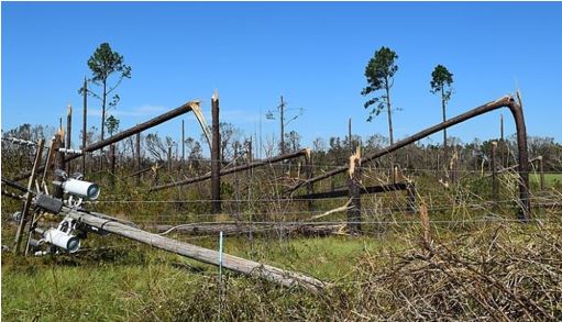
This photo shows downed trees and power lines along Georgia State Road 263 in Seminole County after Hurricane Michael passed by. Photo Credit-Wikipedia-Public Domain.
Five Years Later
After a disaster of his magnitude, recovery is a long and tedious process. All of it was slowed by the pandemic and by the permit process for new construction.
It has been particularly difficult for the pecan farmers in southwest Georgia to recover, Most of them had no insurance. There has been replanting of pecan trees but it will take up to a decade to harvest any of the crop. The only silver lining is that because of advances in agricultural research, these new trees. will be more resistant to fungus. There was a major scare for this area only a few weeks ago when Hurricane Idalia moved up through the Gulf of Mexico. Fortunately, Idalia’s track was far enough east that this area only received a glancing blow.
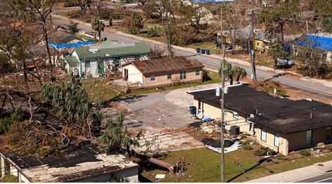
In Florida, recovery and rebuilding efforts in Mexico Beach have accelerated significantly over the past year. Remember that 300 residents left after the storm but about 100 have returned. The city did receive over 100 million dollars in disaster relief and about 50 percent of the damaged structures have been rebuilt. The mayor said that twenty-five new projects are now underway.
A 2023 photo of Mexico Beach, Florida. Photo Credit- Twitter-Public Domain
In Panama City and Panama City Beach, about 60 million dollars of the government issued 300 million dollars in disaster relief has already been used for completed construction projects. 40 million more in construction projects are underway.
These locations rely on vacationers so you might want to pay them a visit when you plan your next getaway!


