

Since weather records were recorded, only two Category 5 hurricanes had made landfall in the U.S. as the 1992 Atlantic hurricane season began. Hurricane Andrew became the third Category 5 hurricane to make landfall in the U.S. on August 24, 1992, in an otherwise quiet tropical Atlantic season.
Andrew’s Voyage Across the Atlantic
If there was a Hall of Fame for Atlantic hurricanes, then Andrew would take its rightful place. Its beginning was rather innocuous as a tropical wave drifted westward off the coast of Africa and into the eastern Atlantic on August 14, 1992. On August 15th, the wave continued to move westward, passing south of the Cape Verde Islands.
On August 16, the tropical wave showed increased convection (thunderstorm activity) and on August 17th, it became a tropical storm with the name Andrew.
Over the next couple of days, an upper-level low-pressure system steered Andrew more to the northwest, so the Windward Islands escaped its effects. Wind shear kept Andrew from developing very much, so there was really no immediate indication of what was to come.
The rather hostile atmospheric environment changed in a hurry on August 21st as Andrew turned more to the west its forward speed increased and the wind shear relaxed. Convection sprouted in a hurry and Andrew grew stronger. Andrew became a hurricane on August 22nd as the central pressure decreased rapidly. By the time it struck Bermuda on August 24th, it had reached Category 4 status and it became a Category 5 hurricane when it reached the Bahamas. Andrew began to weaken a bit as it approached Florida, but it began another rapid phase of intensification prior to landfall. It then dispensed its incredible fury on southern Florida.
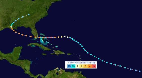
A map showing the track of Hurricane Andrew (with the Saffiir-Simpson Scale) in August 1992. Credit: NOAA/NASA
Extreme Power and Ferocity
Andrew’s first stop was the Bahamas where it began to unleash its wrath. Hurricane watches were changed to warnings on August 22nd for the northern and central Bahamas. Numerous homes and buildings were destroyed from North Eleuthera Island to the Berry Islands. Over 1,700 became homeless. water and electricity were lost for weeks, A wind gust of 138 mph was recorded at Harbour Island.

A satellite image of powerful Hurricane Andrew in the Bahamas on August 23, 1992. ImageCredit- NOAA.
Winds at Nassau gusted to 115 mph. Andrew also produced a number of tornadoes on the islands. Four people died in the storm and damage was estimated at a quarter of a million dollars.
South Florida was next in line as Andrew made landfall around Elliot Key, south of Miami, in the early morning of August 24th. Originally, Andrew was classified as a Category 4 hurricane, but it gained strength as it made landfall and it was later classified as a Category 5 hurricane with maximum sustained winds of 165 mph. The estimated central pressure at landfall was 922 millibars.
Tropical storm and hurricane warnings had been issued for much of Central and South Florida, from Titusville on the east coast to Venice on the west coast. The Florida Keys were included in the warnings.
A state of emergency was declared by Governor Lawton Chiles and there were mass evacuations. Over a half million people were evacuated just in Dade County and the total number of evacuees exceeded 1 million statewide.
Winds at Nassau gusted to 115 mph. Andrew also produced a number of tornadoes on the islands. Four people died in the storm and damage was estimated at a quarter of a million dollars.

A radar view of Hurricane Andrew as it made landfall south of Miami, Florida, early on August 24, 1992. Credit- NWS Miami.
Tropical storm and hurricane warnings had been issued for much of Central and South Florida, from Titusville on the east coast to Venice on the west coast. The Florida Keys were included in the warnings.
On a personal note, my cousin Linda and her husband Bob Minick lived near the Cutler Ridge area just south of Miami. I had paid them a visit in 1989 when I was passing through Miami. I found out that they were very hurricane-conscious, as are many Floridians. They showed me some hurricane tracking charts that they used whenever a hurricane could possibly threaten Florida.
They owned an RV that they used for vacations. About 36 hours before Andrew made landfall in South Florida, I received a call from them while I was on duty at The Weather Channel. They wanted to know how bad it would be and what they should do. I told them point blank ” Get in your RV and get the h— out of there, the sooner the better “!
Many boats along the shore of southeast Florida were destroyed by a storm surge in the 16 to 17-foot range as Andrew came onshore!
Winds were incredibly strong, especially in the eyewall. Wind gusts were estimated to be in the 145 to 150 mph range The only silver lining is that Andrew was a small hurricane and the northern eyewall came in south of Miami Beach or its incredible destruction would have been far worse.
Wind gusts near 170 mph were measured just offshore. Hurricane Andrew plowed through southern Florida like a buzzsaw destroying nearly everything in its path. Damage was extensive from the southern suburbs of Miami on southward.
At the National Hurricane Center in Miami, the radar dome was knocked from its perch, and cars in the parking lot were dropped on other vehicles.
We (The Weather Channel) covered the event with a live crew which broadcast from a hotel near the National Hurricane Center. Dennis Smith gave live updates from a balcony that was facing away from the prevailing wind. It was quite an experience for him and the crew!
The aftermath view of many areas looked surreal – like a massive bomb had been dropped over the area.
The Cutler Ridge Mall suffered severe water and wind damage. Some large trees fell, blocking the main bridge linking the island to Miami. Uprooted trees and toppled electrical poles damaged several of the smaller homes, though a majority had only missing roof tiles. The condominiums and hotels on the island suffered extensive wind and water damage, especially on higher floors.

A photo of the destruction produced by Hurricane Andrew at Cutler Bay, Florida. Photo Credit – NOAA
For those who didn’t evacuate, a harrowing experience could be a mild term.
Some remember the deafening and frightening sounds of the hurricane-force winds as they howled throughout the night and into the morning.
Residents were fortunate to be alive as Andrew’s ferocious winds easily ripped off roofs, collapsed walls in homes, and peeled paint and wallpaper right off of the walls that remained intact.
Many hid under the cover of mattresses or tried to hold doors tight. Appliances were pulled out of homes. Garages were torn away from houses and blown yards away. Cars were picked up and left hundreds of feet away from their driveways.
When the winds subsided, those who ventured outside to examine the damage were in total shock to see the incredible destruction that this hurricane produced.
By the way, my cousin’s home near Cutler Ridge was totally destroyed. Only the utility room remained standing. It was a good thing that they evacuated quickly, even though they encountered a massive traffic jam on the way to Orlando.
The city of Homestead has practically wiped off the map. Ninety-nine percent of mobile homes in the city were destroyed. There was also extensive damage to Homestead Air Force Base.
Because Andrew’s eyewall passed south of Miami, the impact there was far less than it was just to the south. Despite street flooding, broken windows, and downed trees, Miami suffered minimal damage due to tougher building codes. Miami-Dade County, police reports indicated that more than 50 roads were blocked by downed trees and power lines. Across Dade County, Andrew caused the destruction of 25,524 homes and damaged 101,241 others. A Miami-Dade County Grand Jury reported that 90 percent of mobile homes in southern portions of the county were destroyed.
Damage was scattered and much lighter across Broward and Palm Beach counties but strong tropical storm-force winds were reported. if the center of Andrew had come in 20 or 25 miles farther north, the situation would have been dire.
Andrew continued to move westward toward the Gulf Coast as it ravaged the Lake Okeechobee area. It did weaken, but it still managed to inflict significant damage to Collier County. A wind gust near 100 mph was recorded in southern Collier County.

A photo showing the remains of a furniture warehouse that was destroyed by Hurricane Andrew’s wind near Whispering Pines, Florida (Lake Okeechobee area). Photo Credit-NOAA.
A storm surge flooded low-lying areas, particularly in Everglades City and Marco Island. Streets in Everglades City were inundated with more than 18 inches of water. Many boats at Marco Island, were damaged or destroyed by the rough seas and strong winds. A sailboat ripped apart a pier at a Marco Island marina, while a large section of a pier at another marina on the island had their roofs ripped off.
Throughout Lee County, Andrew destroyed 80 mobile homes and severely damaged 400 others. Property damage in the county reached about $30 million.
All told, 44 fatalities were reported in Florida.
Louisiana Bound
Hurricane Andrew moved off the west coast of Florida and it emerged into the Gulf of Mexico. It moved to the west-northwest rather slowly but it was steered by a trough in the upper atmosphere and turned to the northwest toward Louisiana.
Andrew made its second U.S. landfall on August 26th as a Category 3 hurricane about 20 miles west-southwest of Morgan City.
Prior to landfall, the first areas of coastal Louisiana to experience the devastating effects of Hurricane Andrew were the barrier islands such as Isles Dernieres. Isles Derniers lost another 20 percent of its land mass. Just recently, I wrote about the 1856 hurricane that began the process of removing some of Louisiana’s barrier islands.
After landfall, Andrew tore roofs off homes, overturned trailer homes, and left at least 230,000 people without power.
Andrew also produced tornadoes, caused severe flooding, and left at least one person dead. One tornado produced severe damage in La Place where 30 people were injured.

A photo of tornado damage produced by Hurricane Andrew at La Place, Louisiana. Photo Credit-NOAA
Andrew weakened rapidly after landfall, to tropical storm strength in about 10 hours and to depression status 12 hours later. Remnants of Andrew produced heavy rain that locally exceeded 10 inches.
Overall, the death toll from Hurricane Andrew was 65 and the damages exceeded 27 billion 1992 dollars (nearly 60 billion today).


