

All was calm and life was good for Louisiana’s aristocrats on August 8, 1856. Southern Louisiana was filled with sugar beet plantations which made millionaires of their owners. Many of them and their families would frolic at the beaches of a place called Last Island (or Isle Dernière). The island was full of summer homes, and there was a grand hotel where you could bowl, have a game of billiards, or dance. Visitors could explore the island by horse and carriage, or take a ride on a carousel.
There were winds of war whispering across the nation, but the secession of Louisiana from the Union and the actual civil war would not come to pass for another four and a half years.
The oncoming war would permanently change the way of life for Louisiana’s “bon vivant” but there was another wind, the wind of what would be called The Great Storm (La Grande Tempête) that would be the harbinger of things to come.
An Unimaginable Storm
Isle Dernière (Last Island) was a barrier island in the northern Gulf of Mexico, only a few miles off the coast of Louisiana. The island was about twenty- five miles long and from one to five miles wide. It was a great escape for the upper class and other visitors to beat the summer heat and humidity of southern Louisiana.
John Muggah’s Ocean House Hotel was a favorite gathering place on the island. There were also gambling venues and a billiard house there. Proximate to all of this was “Last Island Village” with around 100 beach homes, some were quite lavish for the time. A steamer “Star” transported visitors from the mainland to the island and back.
By August 1856, there were grand visions by investors and developers to make the island even more of an attraction to the wealthy. A small group had come together near New Orleans to map out a plan for the island. It was decided that a much larger and lavish hotel to be called “The Trade Winds” would be constructed in 1857. Little did they know that within a couple of days, these “best-laid plans” would be whisked away forever.
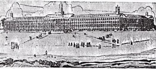
An artist’s conception of the Trade Winds Hotel that would have been constructed on Last Island in 1857. Credit: wordpress.com – Public Domain
The first inkling of the storm was noticed by the island’s inhabitants in the form of rough seas as waves grew higher in the Gulf of Mexico on the evening of August 8, 1856. August 9th was described as a beautiful day. Winds became fresh, out of the northeast, and temperatures seemed a bit cooler than they had been. The Gulf waters remained rough, and waves continued to grow larger and beachgoers could no longer stand in them.
On the morning of August 10th, clouds were increasing rapidly and moving quickly. It had begun to rain and the rain became more persistent and heavier. The wind became stronger by the hour. By early afternoon, the back bay waters were pushed into the north shore of the island.
Residents and visitors became concerned, but they knew that the Star would be coming and it would return them to the mainland. In fact, the Star had temporarily lost its bearings and it was going to turn back. The ship eventually made it to the island, and this would prove to be very fortunate.
There was a vibrant sound of music emanating from the hotel dance hall. Many residents, who were becoming uneasy, went there to escape the increasing effects of the storm. The storm, however, would prove to be overwhelming. For many, these would be the final hours of their lives, and for the rest, harrowing would be much too mild of a term for their ordeal.
The wind became fierce and was ripping off roofs and tearing away shutters, but the hotel stood firm, at least initially. The water across the island rose at least one foot an hour. All elements came crashing in on these poor souls.
Inhabitants, including women and children, were washed away from a rushing storm surge, Some were struck and killed by debris from collapsing houses or crushed by large floating logs. many held on to whatever they could, some with each other.
The horrific wind increased dramatically, possibly to 150 mph. The storm surge was twelve to thirteen feet on an island where the highest point was five feet. Some found their way to the carousel and hung on for dear life, some made it to the Star, which had been pushed ashore by the crashing waves. The Star’s top decks were ripped off but the hull stayed afloat and provided cover for at least 160 people.
Smithsonian magazine.com chronicled a description of the storm by the Reverend R.S. McAllister of Thibodaux, who was a visitor to the island .“Fiery lightning almost constantly illumined the heavens. The Gulf upon one side and the bay upon the other were advancing upon us.”
Houses lost their roofs and were ripped apart. By evening, the hotel was totally destroyed. The island had totally disappeared and every structure on it was destroyed and swept away. The storm was slow-moving, so its effects continued for many hours.
Some people who were swept into the Gulf of Mexico survived by holding on to logs or large pieces of wood, and they were pushed back to the island as the wind changed direction.
All told, there were about 400 people on the island when the storm struck and at least half of them lost their lives. The rest were eventually rescued after somehow surviving the worst force of nature that Louisiana had ever encountered.
The storm crawled inland and severely damaged many sugar plantations. The city of New Orleans was inundated by over 13 inches of rain and the city suffered severe flooding.
This incredible storm actually split Last Island in two and it would never be inhabited again.
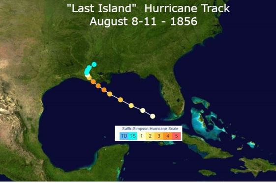
Track of the Last Island Hurricane August 1856. Credit: NOAA/NASA- Public Domain.
Meteorological Conditions That Led To Disaster
Since there were no surface weather maps in 1856, we can only speculate on the specifics of this storm from ship reports and visual observations. What was referred to as “The Great Storm” was actually a hurricane.
This hurricane, the first tropical cyclone of the 1856 Atlantic hurricane season was initially reported on August 8th. it was already a minimal (Category 1) hurricane on the Saffir-Simpson Scale, centered northwest of the Dry Tortugas in the eastern Gulf of Mexico. It was most likely small in size.
For the next two days, the hurricane progressed steadily to the northwest, most likely along the periphery of a high-pressure ridge aloft over the southeastern U.S. and the eastern Gulf of Mexico.
The hurricane also gained strength during this period and likely reached Category 3 strength on August 9th. By August 10th, it slowed down and was probably a strong Category 4 with maximum sustained winds of 150 mph. A ship well away from the center recorded a pressure of 955 millibars. The hurricane’s central pressure was estimated to be at least 20 millibars lower than that.
During the afternoon of August 10th, 1856, the hurricane’s eyewall moved over Last Island. Winds increased from the northeast and eventually shifted to the south and southwest.
The hurricane most likely got caught under an expanding high-pressure ridge and it moved very slowly after landfall. Its center passed west of New Orleans and it eventually turned northeastward toward southwest Mississippi. The storm gradually lost its intensity and it dissipated on August 11th.
It’s estimated that rainfall totals over parts of southern Louisiana ranged from 10-15 inches and it produced severe flooding. In addition to the deaths on Lost Island, many others lost their lives inland across southern Louisiana.
Louisiana Barrier Islands Are Endangered Today
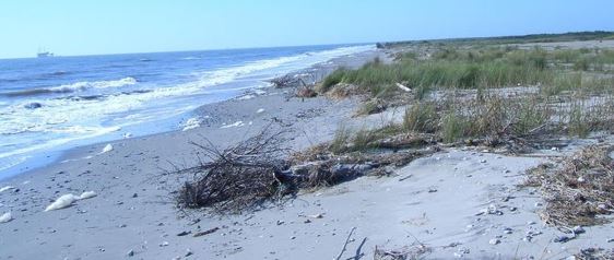 A recent photo of Whiskey Island, one of Louisiana’s Barrier Islands. Public Domain
The Last Island Hurricane wasn’t the only one to strike Louisiana. There was another in 1888 that produced extensive to Louisiana’s sugar crop, There have been subsequent hurricanes and tropical storms since then.
Due to the number of tropical cyclones, rising sea levels, and other factors, there are now five barrier islands off the coast of Louisiana.
According to the USGS “The barrier islands of Louisiana are eroding at an extreme rate. In places, up to 100 feet of shoreline are disappearing every year. Though it has long been assumed that this erosion was due to the area’s rapid rate of relative sea level rise, recent studies by the U.S. Geological Survey show that other coastal processes, such as the longshore redistribution of sediments, are responsible for this erosion.”
It is feared that all of these islands could disappear by the end of the century.

