

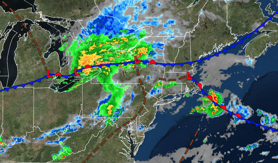
A powerful cold front will bring an end to the hot and humid conditions but not without some powerful thunderstorms this afternoon and evening. Cool and dry conditions take hold tomorrow.
TODAY
A trough will linger over the region with areas of fog in the morning and scattered clouds and scattered thunderstorms in the afternoon. A cold front will follow in the evening with widespread showers and thunderstorms. The thunderstorms will be capable of intense downpours, hail, frequent lightning, wind gusts over 55 mph, and an isolated tornado. Winds will be from the southwest at 5 to 15 mph. Temperatures will rise into the upper 80s to lower 90s over the interior and along the coast and mid to upper 90s for highs. A heat index over 100 degrees will be a threat.
TONIGHT
A cold front will pass through the region with showers and thunderstorms. The thunderstorms will be capable of heavy downpours, frequent lightning, hail, and wind gusts over 55 mph. Winds will veer to the northwest at 5 to 15 mph. Temperatures will fall into the mid to upper 60s over the interior and lower to mid-70s for lows.
TOMORROW
High pressure will take hold with clearing skies and falling humidity. Winds will be from the northwest at 5 to 15 mph. Temperatures will rise into the lower to mid-80s over the interior and along the coast and mid to upper 80s in the Delaware River Valley for highs.
TOMORROW NIGHT
High pressure will exit the region with scattered clouds. Winds will be from the northwest at 5 to 15 mph. Temperatures will fall into the upper 50s to mid-60s over the interior, mid to upper 60s in the suburbs, and lower to mid-70s in urban areas for lows.
MONDAY
A weak cold front will produce scattered clouds and isolated thunderstorms. Winds will be from the northwest at 5 to 15 mph. Temperatures will rise into the mid-70s to lower 80s over the interior, lower to mid-80s along the coast, and upper 80s to lower 90s in the Delaware River Valley for highs.
TUESDAY
A weak trough will produce scattered clouds and isolated showers. Winds will be from the northwest at 5 to 15 mph. Temperatures will range from the mid to upper 50s over the interior and lower to mid-60s along the coast for lows and mid to upper 70s over the interior, upper 70s to lower 80s along the coast, and lower to mid-80s in the Delaware River Valley for highs.
WEDNESDAY
A cold front will move through the region with isolated to widely scattered showers and thunderstorms. Temperatures will range from the lower to mid-60s over the interior and upper 60s to lower 70s along the coast for lows and mid-70s to lower 80s over the interior, upper 70s to lower 80s along the coast, and mid to upper 80s in the Delaware River Valley for highs.
THURSDAY
A cold front will move through the region with widely scattered showers and thunderstorms. Temperatures will range from the upper 50s to lower 60s over the interior and lower to mid-60s along the coast for lows and lower to mid-80s over the interior, upper 80s to lower 90s in the Delaware River Valley, lower to mid-80s along the coast, and upper 70s to lower 80s on Long Island.
FRIDAY
A cold front will move through the region with scattered showers and thunderstorms. Temperatures will range from the mid to upper 60s over the interior and upper 60s to lower 70s along the coast for lows and mid to upper 80s over the interior, lower to mid-90s in the Delaware River Valley, mid to upper 80s along the coast, and upper 70s to lower 80s on Long Island for highs.
SATURDAY
High pressure will produce clear skies to scattered clouds. Temperatures will range from the mid to upper 60s over the interior and upper 60s to lower 70s along the coast for lows and upper 70s to mid-80s over the interior, upper 80s to lower 90s in the Delaware River Valley, and lower to mid-80s along the coast for highs.


