

From June 6th to June 9th, 1953 a powerful storm system moved eastward from the Plains, through the Great Lakes, and into the Northeast. The system produced a deadly tornado around Flint, Michigan on June 8th and on June 9th, a powerful tornado ripped through parts of Massachusetts leaving a trail of death and destruction in its wake.
Countdown To Tragedy
Forecasters at the U.S. Weather Bureau in Boston were tracking a storm system that moved into the Northeast U.S. on June 9, 1953. It had a history of producing tornadoes. Through the 1940s the U.S. Weather Bureau offices weren’t even allowed to mention the word “tornado” in any forecast in order not to cause any alarm to the public.
That sentiment changed as we moved into the 1950s. Old habits seem to die hard, however. Forecasters believed that there was a significant chance for a tornado in Massachusetts but they fell short of mentioning it to the public.
The subject of how to communicate the forecast to the public was discussed during morning weather briefings. 1953 was the first year that severe thunderstorms and tornado warnings could be issued.
On the morning of Tuesday, June 9, 1953, a compromise was reached and a severe thunderstorm watch was issued at 11:30 a.m. This happened to be the first ever watch issued for Massachusetts.
The environment around Worcester, Massachusetts, became increasingly warm and humid during the afternoon. A warm front had moved through and the wind switched to the southwest. By mid-afternoon, Worcester recorded a temperature of 80 degrees and a dewpoint of 66 degrees. With a forecast of afternoon thunderstorms, possibly severe, residents of Massachusetts went about their daily routine.
Ninety Minutes Of Horror
The first sign of trouble occurred at Quabbin Reservoir in Petersham, as three funnel clouds were spotted by boaters. One of the funnels dissipated and the other two moved on to the southeast.
By the time the funnels made it to the small towns of Barre and Rutland, they were touching the ground and they were now full-edged tornadoes. There were two fatalities at Barre where a farmhouse was hit and destroyed. Barbara Knight (age 18) and Eddie White (age 11) were thrown through the air to their deaths. Eddie’s mother suffered a broken back while his sister, June survived after being thrown through a door.
There were also two fatalities at Rutland. By the time it reached Holden, northwest of Worcester, it was one tornado that had rapidly intensified. The twister completely wiped out the Brentwood subdivision and 63 of 75 homes in the White Oaks subdivision. Unfortunately, there were more fatalities. A 12-year-old boy was riding his bicycle and was picked up by the tornado and thrown to his death in a nearby field.
At 5:08 p.m. the powerful tornado reached the north side of Worcester with a width of one mile. Damage around Worcester was catastrophic. At Assumption College, the 3-foot brick walls of the main building entirely collapsed and a priest and two nuns were killed.
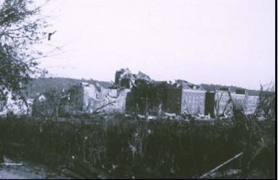
The photo shows catastrophic tornado damage to the main building at Assumption College in Worcester, Massachusetts, on June 9, 1953. Photo Credit- Wikipedia-Public Domain.
The adjacent Burncoat neighborhood suffered major damage before neighborhoods to its east were totally leveled. Homes were totally stripped from their foundations. The intensity of this tornado was officially listed as an F-4 (207-260 mph). There is some conjecture that this tornado could have briefly reached F-5 intensity (261-318 mph). Debris from destroyed homes reached the Boston area, about 40 miles to the east.
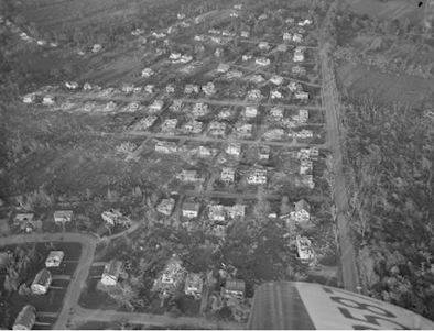
The photo shows subdivisions destroyed by a tornado that struck Worcester, Massachusetts, on June 9, 1953. Photo Credit- New England Historical Society.
A 12-ton bus was picked up and thrown against the newly constructed Curtis Apartments killing two passengers. Later, blueprints of these apartments were found near Plymouth (about 75 miles away)!

A photo of a school bus that was picked up and tipped over by a tornado that devastated Worcester, Massachusetts, on June 9th, 1953. Photo Credit- newspapers.com via Sheboygan Press
A Worcester Dairy Facility (Brookside Home Farm) was totally destroyed. Homes and bodies were picked up and deposited into Lake Quinsigamond. Six people lost their lives in that vicinity, along with 80 cows. The Uncatena-Great Brook Valley area reported 40 deaths. The overall death toll in Worcester reached 60.
The tornado kept its mile-wide width as it moved through Shrewsbury, killing twelve and it tore through downtown Westborough, killing five. The tornado then turned toward the northeast as it hit Southborough where three people lost their lives during the collapse of the Fayville Post Office.

A photo showing stunned survivors of a devastating tornado that swept through Worcester, Massachusetts, on June 9, 1953. Photo Credit – newspapers.com via WorcesterTelegram.
In addition to the tornado, baseball-sized hail was reported in several communities and that is very rare for this part of the world.
The tornado was winding down around 5:45 p.m. when a tornado warning was finally issued.
Another tornado formed about the same time the warning was issued and it struck Sutton, Northbridge, Bellingham, Franklin, Wrentham, and Mansfield, resulting in seventeen injuries. That tornado was rated as an F-3 with winds of 158-206 mph. Other small tornadoes touched down north of Boston and into New Hampshire.
Aftermath
Here are some facts and figures from the Worcester tornado according to an article from the New England Historical Society.
For 90 minutes the tornado stayed on the ground, traveling 48 miles from Petersham through Worcester to Shrewsbury, Southborough, and Westborough. It dissipated over Framingham. and Westborough. Finally, it dissipated over Framingham, It officially killed 90 people, injured 1,300, and destroyed 4,000 buildings. More than 10,000 people lost their homes.

This photo shows one of the thousands of homes that were destroyed by a tornado that moved through Worcester, Massachusetts, on June 9th, 1953. Photo Credit- New England Historical Society.
The Worcester tornado was New England’s costliest tornado (over a half million in today’s dollars). Its 1,300 injuries were the 3rd worst in U.S. history until the Wichita Falls, Texas, tornado in 1979 bumped it down to number four. The 10,000 homeless stood unchallenged for 26 years until the 1979 Wichita Falls tornado.
It was the worst tornado in New England history and one of the 25 worst tornadoes in U.S. history.
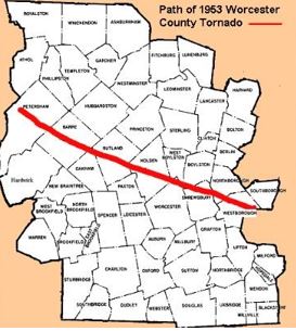
A Massachusetts county map showing the path of the June 9, 1953, tornado. Map Credit-Public Domain.
The tornado was responsible for the reorganization of the Storm Prediction Center on June 17, 1953, and the subsequent implementation of a nationwide radar/storm spotter system. Since June 9, 1953, no single U.S. tornado had killed over 100 people until the Joplin, Missouri tornado of May 22, 2011.
Many residents of the area thought that the Soviet Union had attacked Massachusetts or that the nuclear testing in the Southwest U.S. triggered the event.
The National Guard was called in to ease panic and search for bodies or possible survivors trapped in the rubble. Several small children were found under the bodies of their deceased parents. Several dead bodies of husbands and wives were found in an embrace.
Massachusetts Senator John. F. Kennedy came to the devastated area the next day to survey the damage.

A photo of Senator John F. Kennedy surveying tornado damage with Melissa Tyler and Richard Meger in Shrewsbury, Massachusetts, on June 10th, 1953. Photo Credit-Worcester Telegram.
Meteorological Conditions
A storm system proceeded eastward from the Upper Midwest through the Great Lakes and eastward to New England. from June 6th to June 9th, 1953.
On June 9th an upper-level trough swung into the Northeast U.S. A surface low-pressure system was over southeast Canada in the morning with a cold front extending into New York state and a warm front into eastern New England.
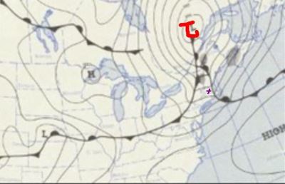
A surface weather map for June 9th, 1953 shows low pressure over Quebec with a cold front extending southward into Upstate New York.
Worcester, Massachusetts, (x) was in the warm sector. As mentioned earlier, the temperature reached 80 degrees and the dewpoint was 66 degrees. The upper trough was enough to create plenty of instability and wind shear. Add to that the lift from daytime heating and you had a recipe for severe weather.
Amazingly, the hook echo from the tornado showed up well on the radar.
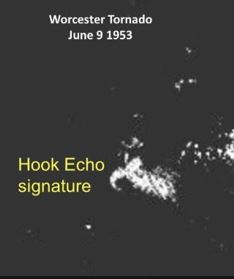
Although radar was quite primitive back in the 1950s, the Worcester tornado “hook echo” showed up prominently. Photo Credit- Bulletin of the American Meteorological Society.
As mentioned, the meteorologists at the U.S. Weather Bureau were well aware that severe thunderstorms were likely and tornadoes were at least possible but the “cultural” atmosphere at the time ended up holding them back from issuing a tornado warning.
Fortunately, we have come a long way in forecasting severe weather and using advanced radar technology to identify tornadoes and possible tornadoes. Timely warnings are now issued.


