

Spring was definitely in the air across the Northeast U.S. as April arrived more than forty years ago in 1982. New York City exceeded 70 degrees under bright sunshine on April 2nd. It seemed nearly impossible that only a few days later, the Northeast would be slammed by a record-setting and deadly blizzard that would stop the region in its tracks.
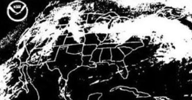
A satellite image shows clouds associated with a massive winter storm over the Northeast U.S. on April 6, 1982. Photo Credit- NOAA.
The Blizzard – New York City Metro
Although spring-like conditions prevailed on Friday, April 2nd, the atmosphere was about to become much angrier. A combination of weather factors would align just right to produce a historic event.
Forecasters at the National Weather Service in New York became aware over the weekend that snow would be possible on Tuesday. By Sunday, initial forecasts were calling for a couple of inches but by Monday, they were warning about a much higher impact event. Heavy snow would fall and wind gusts would be strong.
The wording from the National Weather Service became more alarming as they were expecting a “life-threatening” blizzard with heavy snow, and strong winds with snowfall accumulations up to a foot. Blizzard warnings for the forecast area were issued.
A light rain began to fall on Monday evening as temperatures held in the low 40s. Those who were awake through the night remember that the rain continued through the 4 a.m. hour on Tuesday morning.
Conditions changed rapidly during the next couple of hours from northern New Jersey, through New York City, and into Connecticut, as temperatures dropped down through the 30s.
Rain quickly changed to snow and heavy snow filled the skies. A cold wind was picking up and it became very difficult to get around as the snow began accumulating on road surfaces. It was also difficult to see as visibilities were declining rapidly. In addition, lightning and thunder accompanied the storm.
One resident of northern New Jersey recalled the events as they unfolded. “My memory is rain changed to heavy snow and the snow started accumulating before dawn. Temp was 34 at daybreak, 32 at 8 am, 22 around noon, and 21 late in the day and thru the night. 35-45 mph sustained winds with gusts to 60 mph brought windchills below zero all day. Whiteout conditions often that day and there was also loud thunder on a few occasions.”
The streets of New York City became one large log jam. Suburban and country roads became sheets of ice and snow as the temperature dipped well down into the 20s. With winds constantly around 40 mph and visibilities at or near zero, this storm met the qualifications of a blizzard”.
This photo is an eerie sight during the blizzard, adjacent to Roosevelt Field near Hempstead, New York, on April 6, 1982. Public Domain.
Local airports were shut down but La Guardia and JFK were able to open one runway in the evening. The Long Island Railroad was also shut down. Traffic on the Long Island Expressway was backed up for many miles.
The New York Yankees had a baseball game scheduled for that day which was, of course, postponed. Their next three games were also postponed. Record-cold temperatures following the storm kept the snow from melting as fast as it usually would in April.
Central Park in New York City picked up 9.6 inches of snow from the storm, while over 10 inches fell in the Bronx. Many thousands of residents were without power.
This photo shows snow and ice on a street in Wantagh, New York, during the blizzard on April 6, 1982. Photo Credit- YouTube.
The storm also slammed the Hudson Valley with heavy snow and strong winds. Locations from Albany to White Plains ended up with 12 to 18 inches of snow. Early commuters from the Hudson Valley to New York City became stranded there that night. The storm brought Albany, New York to a standstill. The 17.3 inches of snow recorded at Albany is an April record.
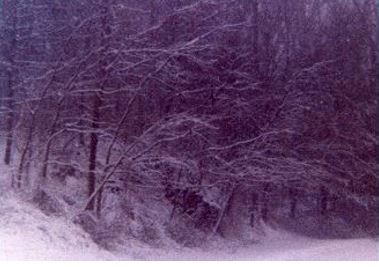
This photo shows heavy snowfall just outside of White Plains, New York on April 6, 1982. Photo Credit- MOCKBA1
New England
The storm moved northward during the day. Connecticut and Rhode Island were feeling the full effects by mid-morning, and it moved into the Boston area before noon. Heavy snow and fierce winds reduced visibilities to zero at times. Just like in the New York City area, lightning and thunder accompanied the snow. The city was paralyzed soon after the storm hit. It didn’t help matters as schools were let out by midday in Boston.
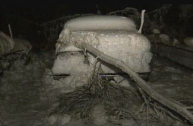
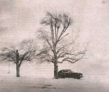
A photo shows a large tree limb on a snow-covered car near Boston Massachusetts on April 6, 1982. Photo Credit- YouTube.
Hundreds of auto accidents occurred almost immediately after the storm struck. There was a fifty-car pileup on I-495 and a twenty-car crash on the Massachusetts Turnpike. Boston, Massachusetts recorded 13.3 inches at Logan Airport but totals up to 18 inches were reported in the suburbs. Hartford, Connecticut received 14.4 inches. Providence, Rhode Island reported 7.6 inches. Worcester, Massachusetts, picked up 15 inches, and Plainfield, Connecticut saw a whopping two feet of snow!
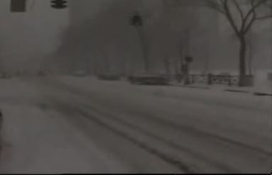
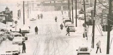
A photo showing a snow-covered street during a blizzard near New Haven, Connecticut on April 6. 1982. Photo Credit-YouTube.
Logan Airport in Boston and Bradley Field near Hartford were both shut down during the storm. The strong winds resulted in thousands of power outages. At Cape Cod, 20 to 30-foot waves were observed. The Blue Hill Observatory, near Boston, reported a wind gust of 68 mph. All in all, eight fatalities were reported in Massachusetts as a result of the storm.
In Hull, Massachusetts, 13 -year old paper delivery boy, Thomas Young, had just started his newspaper delivery route on Monday. Thomas, who didn’t want to let his customers down, started on his route to make his deliveries.
Unfortunately, due to the extreme wind chill, he collapsed in a snowbank. By chance about two hours later, a man found Thomas and they rushed him to the fire station for treatment. Fortunately, he recovered quickly and was sent home.
Farther north, parts of Maine fared no better as the storm swept in during the afternoon and continued through the evening and into early Wednesday. Snow and motor vehicles clogged the streets of Portland, Maine, where 16.9 inches of wind-driven snow fell.
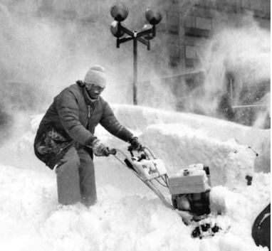 A photo of a man trying to clear a path on a street in Portland, Maine, during the April 6/7 1982 blizzard. Photo Credit- Maine Historical Society.
For many reporting stations in New England, the 1982 blizzard was the worst April storm on record at that time as previous snowfall records were shattered.
Meteorological Conditions
As mentioned earlier, a combination of weather factors came together just right to produce a storm of this magnitude. Over the weekend, a trough in the upper atmosphere emerged from the Rockies and moved eastward. There was an area of low pressure at the surface associated with this weather system. The storm produced strong winds and 10-inch snowfalls at Milwaukee and Detroit and 8 inches at Cincinnati. Parts of northwest Pennsylvania reported 65 mph winds and 10-foot snow drifts.
Meanwhile, another upper-level trough was moving eastward through the southeast U.S. This system reorganized along the East Coast of the U.S., and another surface low developed.
A “phasing” of these two upper-level troughs occurred around the Mid-Atlantic to create one massive low-pressure system.
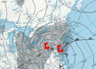
A surface weather map from April 6th, 1982 shows a complex storm across the Northeast U.S. Map Credit- NOAA Central Library.
At the same time, some very cold air was perched and ready to come southward from Canada and that’s just what it did as the storm developed. The New York City metro area temperatures fell to the low 20s during the afternoon of April 6th.
Odds And Ends
I didn’t get to experience the April blizzard of 1982, firsthand so how do I find a way to add something here? The Weather Channel didn’t lunch until May 2, 1982, so we didn’t get a chance to cover this storm. We had all reported for work, however, on March 1, 1982, in Atlanta.
For the two months prior to the launch, Meteorologists (forecasters) and On- Camera Meteorologists went through their daily routines just as if we were on the air (dry runs). This was the most significant weather event to occur during that (practice time) so we did create forecasts and maps (with the help of computer models) just as if we were actually in operation, so I remember the blizzard well.
This storm only goes to show that even if the calendar says April, significant snow events are still possible over parts of the U.S.

