

On Sunday, March 27, 1994, a number of devastating and deadly tornadoes raced across the Southeast. The brunt of the devastation took place from north-central Alabama, through northern Georgia to the Carolinas. All told, forty-two people perished and over three hundred and twenty were injured.

A map showing the path of tornadoes that touched down during a major outbreak on March 27, 1994. Map Credit- NOAA.
It was twenty-nine years ago on a quiet Sunday when the lives of many in the Southeast were either ended or changed forever. In St. Clair and Cherokee Counties in Alabama, it was a warm and humid morning as many residents prepared themselves to attend church services.
Weather conditions, however, were ripe for the development of powerful thunderstorms, and even tornadoes. On March 26th, the Storm Prediction Center’s Convective Outlook, for the next day, featured an area across the Southeast that were under the gun for severe weather. They indicated a strong possibility of supercell thunderstorms and a strong possibility of tornadoes.
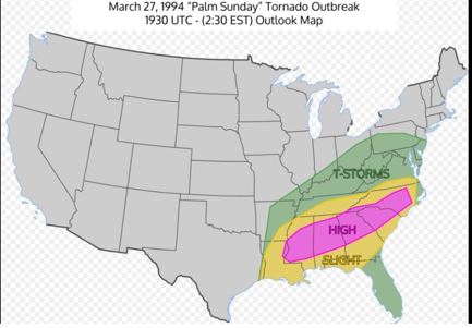
Storm Prediction Center Convective Outlook for Sunday, March 27, 1994.
The Event
Severe thunderstorms were already underway across parts of northern Mississippi and northern Alabama during the morning. At 9:18 a.m. a tornado watch was issued by the Storm Prediction Center (SPC) for eastern Mississippi and northern Alabama. Thunderstorms rapidly strengthened and tornado warnings. were quickly issued. The storms then rapidly intensified, with tornado warnings being issued by NWS Birmingham and NWS Huntsville.
In Goshen, Alabama, worshipers were on their way to services at the United Methodist Church. Little did they know that a major tragedy was about to occur. Their church would take a direct hit from a violent tornado and those inside the church were unaware of the situation.
Alabama
Here is an overview of the tornado that struck the area in that time frame that was issued by the NWS.
The first violent and the deadliest tornado of the outbreak developed one-mile south-southwest of Ragland in St. Clair County, Alabama, at 10:55 a.m. CST. With a 45-to-55-miles-per-hour forward speed, the tornado first destroyed buildings east of Ragland before killing a woman on a campground west of Neely Henry Lake.
Just prior to entering Calhoun County, the tornado destroyed eighteen homes and twenty mobile homes. Upon crossing the north side of Ohatchee, the tornado threw a van into a ditch, killing a man inside and injuring three other occupants. After causing death on U.S. 431, passed through sparsely-populated, wooded land about four to five miles northwest of Piedmont.
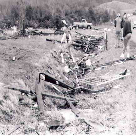
As it passed north of Piedmont, the tornado struck the Goshen United Methodist Church in the former community of Goshen, killing twenty people in the church and injuring ninety-two. The tornado also destroyed two nearby churches but killed no one in their congregations. Parishioners in the Goshen United Methodist Church apparently received no warning during the service and many were crushed to death as the walls and roof collapsed upon them.
The tornado caused the south wall which was eighteen feet tall and sixty feet wide (built solely of masonry blocks) to collapse inward. The timber-and-steel gable roof and other walls followed suit, crushing parishioners inside the sanctuary. After striking the church, the tornado continued on and later dissipated five miles northeast of Rock Run, near the Alabama–Georgia state line. Overall, the tornado killed twenty-two people.

A photo showing extreme damage to the United Methodist Church in Goshen, Alabama on March 27, 1994. Photo Credit- NOAA.
Dan Satterfield was a Meteorologist at WBRC in Birmingham at the time and he posted this recollection of the event on his Facebook Page in 2019.
Twenty-five years ago today an F-4 tornado hit a church in Goshen Alabama. It wiped it out and killed many. I was on air at WBRC in Birmingham and that day is burned in my memory. When storm spotters confirmed a large tornado, I went into the control room and said we need to activate the Emergency Broadcast System. They said we have no test scheduled. I said it’s not a test we have a half-mile-wide tornado killing people.
Someone said, “I’m not sure we know how to do it for real”. I replied, “We have to figure it out in the next three minutes”. They did! Many people told me later that when that tone came up and I said this is not a test, they took it seriously. I ended up being a neighbor of the minister of that church who lost his daughter that day. For Meteorologist James Spann and me, that day is one we will never ever forget. I was standing in the rubble of that church later that day doing a live shot for ABC News. The rain was still washing away the blood on the ground. Those images stay with you forever.
The church was left in ruins as the tornado raced away. Stunned survivors were rummaging through the rubble, and stepping around bodies to find and tend to the injured. Many could not sleep and they suffered intense anxiety when subsequent thunderstorms would move through the area. Other tornadoes struck the state, as well.
Here are tornado summaries issued by the NWS.
Marshall County – Tornado (F2)
A tornado traveled southwest to northeast across an area just south of the city of Guntersville. The tornado apparently began along Highway 79 South and then crossed Big Spring Creek damaging a number of residential structures along Spring Creek Drive. The tornado appeared to weaken but was still strong enough to rip off the top part of the roof of the Marshall Nursing Home and damaged several houses near the entrance to Happy Home. It crossed U. S. Highway 431 near the high school taking out some trees on the side of the mountain and damaging a couple of homes. A total of one hundred and three houses were damaged, forty-five of them along Spring Creek Drive and eight along Highway 79 South. In addition, hail with a diameter of 0.75 inches fell near Arab at 1055 am CST, and 1.75 inches in diameter was reported at Guntersville at 1115 am CST.
Dekalb County – Tornado (F3)
A tornado struck near the Grove Oak area in the western sections of Dekalb County moving northeast through the towns of Rainsville, Sylvania, and Henager. In the path of the tornado, Emergency Management personnel reported sixteen homes and 13 mobile homes completely destroyed, 45 homes and 2 mobile homes with major damage, and 21 homes and 9 mobile homes with minor damage. Two businesses and 12 poultry houses were destroyed. In addition, 0.75-inch hail was reported at Sylvania at 1148 a.m. CST, and at Henager at 1157 a.m. CST.
At 1150 am CST golf ball size hail was reported in southern Cherokee County, ten miles southeast of Centre, with the thunderstorm that produced the tornado.
Blount County – Tornado (F0)
At 1157 am CST, a tornado was reported in the Sugar Creek Community about three miles southwest of Nectar along Alabama 160. The storm damaged six homes, downed power lines, and trees, destroyed three greenhouses, and damaged a fourth.
Tuscaloosa County – Tornado (F1)
Around 402 pm CST, a tornado struck in an unpopulated area of Tuscaloosa County about fifteen miles northeast of the center of Tuscaloosa. A 115-kilovolt power transmission line operated by Alabama Power Company was broken when two power structures were downed; a third was leaning.
Georgia
The storms then proceeded to Georgia where they produced much more damage and caused more deaths. An F-3 tornado swept through northern Georgia.
Here are the summaries issued by the NWS.
3 deaths — A long-tracked tornado descended to the ground about seven miles north-northwest of Dawsonville at 2:17 p.m. EST. The tornado initially downed power lines and trees as it produced F-0 damage in rural locations, but it grew in size and intensity as it entered Lumpkin County. Widening to 0.25 miles wide, the tornado caused widespread F2 damage to hilly terrain as it snapped sixty-to-eighty-foot tall pine trees.
Upon reaching an area near Gordon Seabolt Road, about 2.5 miles (4.0 km) west-northwest of Dahlonega an elderly man was killed by flying debris. The tornado passed just 1.5 miles north of Dahlonega and later killed another elderly man in a mobile home four miles northeast of Dahlonega. In this area, the tornado destroyed many “brick and wood” homes.
Thereafter, the tornado crossed the northwest slope of Yonah Mountain and then attained its peak intensity, F3 on the Fujita scale, as it broadened to 1.25 miles wide and inflicted severe damage to homes about 7 miles northeast of Cleveland. There, it “completely leveled” ten homes and badly damaged 25 to 30 others.
The tornado then weakened to F2 strength and continued on to kill a person in a mobile home 6 miles (9.7 km) north of Clarkesville. It maintained intensity through rugged terrain until it lifted 6.5 miles (10.5 km) northeast of Clarkesville at 3:02 p.m. EST. Along with its path, the tornado caused over $17 million in property damage, killed three people and more than 500,000 chickens, and snapped “hundreds of thousands” of trees.
Another tornado wreaked havoc on parts of northwest Georgia.
9 deaths — The second-deadliest tornado in the entire outbreak—and the deadliest of the outbreak in Georgia—touched down about 4.5 miles south of Adairsville in Bartow County at 3:01 p.m. EST. Proceeding to the northeast, the tornado quickly strengthened to F2 intensity as it severely damaged five to seven homes and snapped trees in half. Tornadic winds blew trees onto a truck, killing its occupant inside.
Next, the tornado increased to F3 strength and widened to .75 miles as it passed through Pleasant Valley. There, the tornado threw a 4,000-pound pickup truck for 300 yards and destroyed or heavily damaged 25–30 homes of brick or wood construction. The tornado was reported to be so large and fast-moving like the 1925 Tri-State Tornado – a “rotating fog bank” indistinguishable from the cloud base as it passed through Pleasant Valley. Afterward, the tornado retained F3 strength as it passed 1.5 miles north of Funkhouser and heavily damaged three to five homes of brick or wood construction.
It went on to destroy or damage four homes near the intersections of Bartow, Gordon, and Pickens Counties. Entering Pickens County, the tornado grew to 1.5 miles wide, snapping most trees at their base, and killed six people in a trailer that was thrown 100 to 250 yards. It then killed two more people as it destroyed a single-story residence and a mobile home before lifting 3 miles northeast of Jasper.
It caused a total of $12,250,000 in damage and killed a total of nine people along its path. At one point, according to engineer Timothy P. Marshall, the tornado moved at 60 miles per hour and downed 1,000 trees each second.
A second, weaker, F2 tornado overlapped part of the path of this tornado and hit Pleasant Valley just 30 minutes after this F3 tornado left.
A photo shows a destroyed mobile home in Pickens County, Georgia on March 27, 1994. Photo Credit-NOAA
I remember this day well because there was a tornado warning for my county and an F-0 tornado touched down very close to where I was living in Kennesaw, Georgia.
The outbreak continued in northeast Georgia before crossing into South Carolina.
A tornado badly damaged five buildings at Tallulah Falls before descending a 500-foot cliff. It destroyed about 60 homes in Oconee County, South Carolina, with $5.5 million in damage. It was part of the Piedmont, Alabama, tornado family as items from that town, more than 140 mi (225 km) to the southwest, were found at Tallulah Falls. The tornado was F2 at Tallulah Falls and F3 in South Carolina.
Carolinas
Here are the summaries issued by the NWS.
A long-tracked tornado destroyed two mobile homes, badly damaged another home, and ripped apart three transmission towers (all indicative of F2 damage) before crossing into North Carolina. Upon entering North Carolina, the tornado downed three high-voltage transmission towers about 15 miles southwest of Shelby. Just 300 yds ) to the northeast of the transmission towers, the tornado destroyed a home along with a large barn house, plus three additional transmission towers, four mobile homes, two vehicles, and a cinder block structure nearby.
Nearing Boiling Springs, the still-F2 tornado struck Gardner-Webb University and damaged several vehicles that were parked on campus. Just afterward, it hit downtown Boiling Springs, destroying an apartment duplex, a flower shop, and a car-wash station. After leaving Boiling Springs, the tornado weakened to F1 intensity and leveled a greenhouse north of highway 150It also blew down many trees before entering Shelby, damaging a steeple and a billboard. in town.
It then intensified somewhat and badly damaged homes, trees, and power lines before passing 3 miles south of Cherryville. As it passed near Cherryville, the F1 tornado caused a porch roof to collapse east of highway 274. It also broke trees and blew a roof off a barn. Farther along, the tornado also badly damaged three mobile homes. After crossing highway 279 the tornado finally dissipated as it approached the town of High Shoals in Gaston County.
This was followed by yet another F3 tornado
A tornado produced F1 damage in South Carolina, destroying a mobile home and an outbuilding; it also damaged many other mobile homes and outbuildings in Lake Wylie.
After crossing into North Carolina, it destroyed a brick home and three mobile homes before striking the Catawba River. Next, the tornado struck the Charlotte airport where an Air National Guard building lost its roof. Many vehicles and a DC-9 aircraft sustained damage as well. Two people were injured. The tornado then struck apartments and homes, several of which lost three-story walls and there was significant roof damage.
Nearby, the tornado ripped steel poles at a restaurant from their concrete foundations, downed large trees, and caused significant damage to an elementary school before lifting just north of downtown Charlotte. At least two, and possibly nine, people were injured along the path.
All told the tornado outbreak lasted for twenty-one hours and forty minutes. There were also numerous hail and wind damage reports. The largest hailstone (4.5 inches in diameter) was the size of a grapefruit.
Damage was estimated at nearly 250 million dollars. There were forty fatalities and four hundred and ninety-one injuries.
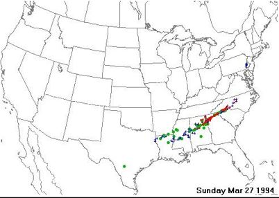
A map showing storm reports (severe) for the outbreak on March 27, 1994. Tornado (red) Hail (green) Wind damage (blue). Map Credit- SPC.
Meteorological Conditions
Atmospheric conditions were ideal for severe weather. The affected area was in the warm sector of a storm system. Temperatures were warm and humidity levels were elevated. A stationary front stretched from Alabama to North Carolina. several tornadoes ran east-northeastward around that boundary.

There was a strong upper-level trough out to the west. Forecast atmospheric soundings from Centreville, Alabama of CAPE (Convective Available Potential Energy) which is a measure of the amount of energy available for convection was very high. CAPE is directly related to the maximum potential vertical speed within an updraft- thus, higher values indicate a greater potential for severe weather) Values were very high (over 2,600) and helicity (turning of wind with height in m2/s2). Helicity (wind shear) values were also very high (443) which was excellent for rotating storms to develop.

Upper-level atmospheric soundings from Centreville, Alabama on March 27, 1994, indicating high CAPE and Helicity values. Image Credit NWS,
It is no wonder that there was so much violent weather that day.
Aftermath
Here is an assessment of the warning system for that day from the NWS.
The warning process was also somewhat compromised by the limited resources many rural county emergency managers and law enforcement officials had at their disposal for receiving the emergency messages and enacting their preparedness response plans. Few had NOAA Weather Wire Service (NWWS), the most effective warning delivery system.
Most emergency managers relied on their Law Enforcement Telecommunications System (LETS), despite the fact messages can be delayed on these systems. Some only had NWR as the sole source of NWS warnings and related information and praised the system’s usefulness. The 16 television and radio stations surveyed in Alabama and Georgia gave NWS personnel high marks for providing early and timely warnings throughout this outbreak.
There were some indications, however, that the process for activating the Emergency Broadcast System (EBS) was faulty. None of the ten radio stations surveyed had NWWS, the most efficient way of activating the EBS. Instead, they relied on manual receipt of NWR broadcasts, a phone call from their county emergency management agency, or a bulletin received through the Associated Press (AP) news wire. Stations surveyed had widely varying methods for activating EBS, and some did not keep logs of when the EBS was activated.
This further emphasizes the urgent requirement for the EBS to be upgraded into an automated system, as the Federal Communications Commission (FCC) is planning.
Overall, considering the frenetic activity and tension associated with wave after wave of supercells in a day-long severe weather episode, NWS personnel at WSFOs Birmingham and Atlanta and WSO Athens issued timely warnings for most of the affected counties in their areas of responsibility.
They issued a combined total of seventy-five tornado warnings and sixty-two severe thunderstorm warnings. Many emergency managers, law enforcement of officials, the media, and several survivors interviewed by the DST stated that, through the efforts of these NWS of offices, many lives were saved.
Now that severe warning systems have improved dramatically, especially in rural areas, many more lives can be saved if this type of event should occur again.

