

It’s been over sixty years since a very deadly and destructive storm left an indelible mark on the East Coast. A unique set of meteorological circumstances came together to produce this memorable event.
The “Ash Wednesday” Storm, as it came to be known, stalled along the U.S. East Coast in early March of 1962. The storm was ranked among the top ten most destructive of the 20th century by NOAA. It literally chewed up the coastline from North Carolina to the south shore of Long Island and it dumped heavy snow inland. In all, the storm claimed 40 lives, over 1,250 were injured and the total damage was estimated at 200 million (1962) dollars which would be nearly 1.8 billion dollars today.

An image from the Front Page Of the Plainfield (NJ) Currier News on March 7, 1962. Image Credit-newspaperarchive.com.
Although the “Ash Wednesday Storm” produced most of its damage from North Carolina to Long Island, areas to the north and the south of the storm also felt its effects.
The storm first affected the Southeast U.S. on March 5th, 1962. Light snow fell in northeast Alabama.
Daytona, Beach, Florida, reported winds of 42 mph, Tides were two feet above average at Vero Beach, Florida. High waves battered coastal areas and beachfront property damage in northern Florida reached 1 million (1962) dollars.
To the north, a few days later, high waves blasted coastal areas of southern New England and Block Island reported a wind gust to 84 mph. High waves flooded coastal areas all the way up to Maine. Very little precipitation made it up to New England with the storm, however.
The storm system stalled off the coast of North Carolina and Virginia on Tuesday, March 6th, and its devastating effects continued through Thursday, March 8th. High waves and heavy rain were relentless.
The storm lasted through FIVE high tide cycles. To make matters worse, the moon was near Perigee (its closest point to the Earth during that time). It was also “Perigean Spring Tide” where the moon was in alignment with the sun and the earth. Plus, it was also the time around the new moon.
The relentless east-to-northeast wind blowing across the surface of the Atlantic Ocean, along with the astronomical conditions, made the high tide even greater. Since this beast of a storm mainly affected the Mid-Atlantic region, we will start with North Carolina and work our way northward.
North Carolina
Relentless high waves pounded the east side of the Outer Banks and obliterated sand dunes. A new inlet was created by the storm on Hatteras Island. Much of Highway 12 was washed away or buried in the sand. Cars were covered entirely with sand. Inland, accumulating snow fell around Greensboro and northward into Virginia.

The image shows a bulldozer trying to repair beach damage at Nags Head, North Carolina from the “Ash Wednesday” Storm in March of 1962. Image Credit-YouTube.
In Norfolk, one high tide reached 8.2 feet which is their third-highest on record. thousands of cars and homes were flooded in the Tidewater area. Hampton Roads measured a wind gust of 65 mph and a gust of 80 mph was reported around the lower Chesapeake Bay. Streets, roads, and highways suffered massive flooding and it was nearly impossible to get around.
At the time, construction of the Chesapeake Bay Bridge was underway but that work was delayed when wind gusts produced waves up to 50 feet which destroyed the world’s largest pile driver that stood on four one hundred-foot legs.
The pile driver became buried in sand and two workers had to be rescued by helicopter. Thousands of residents along the coast had to be rescued during this unrelenting storm.
Boats and homes were destroyed on Chincoteague Island and several “Chincoteague Ponies” perished. Monetary damage in Virginia reached 30 million (1962) dollars which would be nearly 300 million dollars today. At Wallops Island, one million dollars in damage was done to the NASA Flight Facility.
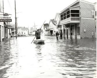
The photo shows a man navigating by boat on a flooded street on Chincoteague Island, Virginia, after the “Ash Wednesday Storm in 1962. Photo Credit- Pinterest.com/David Parker.
Inland, heavy snow buried the Blue Ridge Mountains and the Shenandoah Valley areas. One reporting station in the Blue Ridge Mountains measured 42 inches of snow. Harrisonburg, Virginia, saw 27 inches and Winchester picked up 23 inches which was a record snowfall at the time.

A photo of a helicopter that brought supplies to isolated residents of the Harrisonburg, Virginia, area during the “Ash Wednesday Storm” in March of 1962. Photo Credit-Heritage Museum.
Many residents of those communities were stranded and travel came to a halt, The U.S. Army had to fly helicopters into some locations to deliver much-needed supplies to anxious people.
Maryland
The damage to the coastline was described by many as incredible! High tides were estimated to be up to 6 feet above average. Sand dunes and beaches were washed away. Extreme flooding resulted in road closures and it washed away many beach homes.
Heavy rain produced flooding and power was lost over a large area. Inland, 1.2 million chickens, and eggs were lost because of the storm.
Maryland Governor Millard Tawes declared the event the “worst disaster in my time in the state of Maryland.” The governor had surveyed the massive amount of damage to Ocean City by helicopter.
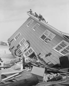
The photo shows inspectors surveying extreme damage to a house In Ocean City Maryland after the “Ash Wednesday Storm” in 1962. Photo Credit-Baltimore City Life Museum.
As the storm approached, the U.S. Weather Bureau had alerted the public that a nor’easter was coming but the residents had no inkling that the powerful and relentless storm would last for three days. Forecasting tools that are used by meteorologists today weren’t available back then.
There were three fatalities in Maryland from the storm.
Delaware
At the Delaware Breakwater, one high tide reached 9.3 feet above average before the gauge failed but it was estimated to be an incredible 11 feet above average. Rehobeth Beach saw waves up to 40 feet high.
Saltwater penetrated well inland and it destroyed many agricultural fields. There were seven fatalities in the state.
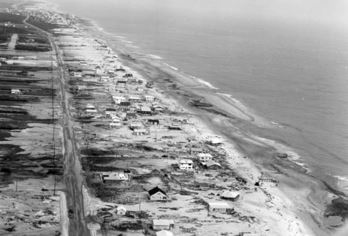 The photo shows the damage inflicted at Bethany Beach, Delaware, by the “Ash Wednesday Storm” in March of 1962, Photo Credit-Delaware Public Archives.
New Jersey
Coastal residents of New Jersey were given little or no warning that a storm of his magnitude, intensity, or duration was on the way. Meteorologists had no idea that the storm would stall and end up as a three-day event.
In Atlantic City, a quarter-mile section of the Steel Pier washed away. One high tide at Atlantic City was about 10 feet above average. Thousands of stranded residents attempted to escape coastal areas by boat but they were stopped by icy waters. The US. Army sent in helicopters to evacuate many residents.
In many coastal towns, boardwalks were destroyed, rail lines were compromised and electricity was cut off. Homes that did withstand the storm were without heat and sewage facilities for an extended period. Downed power lines sparked numerous fires that continued to burn because fire stations couldn’t get their trucks into those areas.
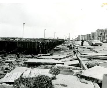
The photo shows extensive damage at Atlantic City, New Jersey, from the “Ash Wednesday” Storm in March of 1962. Photo Credit – Atlantic City Free Public Library.
The death toll in New Jersey was 14 and another dozen went missing and were presumed dead. In Avalon, New Jersey, six entire blocks were destroyed.
Farther north, one hundred homes were destroyed on the south shore of Long Island with high tides over 8.5 feet above average.
In the Atlantic, the storm split a 500-foot Liberian tanker in half. Three Navy destroyers had to be sent to rescue twenty-seven men that were left stranded. In addition, fifteen men were lost at sea on fishing trawlers.
Meteorological Conditions
On March 4th, low pressure developed off the Southeast Coast of the U.S. A deep trough of pressure aloft was around the Ohio Valley moving southeastward. In the upper atmosphere, a high-pressure ridge was building over Canada south of James Bay.
The upper-level trough slid southeastward helping the coastal low to intensify on March 6th. The low’s central pressure dipped to 979 millibars. The upper trough closed off around the Carolinas south of the high-pressure aloft. Meteorologists call this a “Rex Block”.
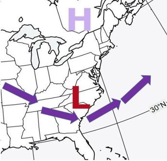
The map above (which I created) shows the 500 millibar pattern “Rex Block” on March 7, 1962, which caused the “Ash Wednesday Storm” to stall.
The surface low responded by stalling and wandering around off the coast of the Carolinas and Virginia. Also, at the surface, high pressure built into Quebec. The strong pressure gradient between the low and the high created strong winds.
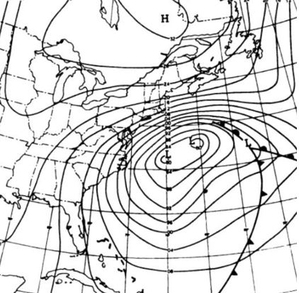
A surface weather map for March 7, 1962. Note the number of isobars north of the low indicating a strong pressure gradient. Map Credit-U.S. Weather Bureau.
The stalling low-pressure system kept a persistent east-to-northeast wind over the Mid-Atlantic region and high waves continued to batter the East Coast for three days. The astronomical condition that I mentioned earlier produced extremely high tides for five tide cycles.
Many nor’easters produce coastal damage but at least most of them move along. This one certainly was a deadly and destructive exception. Heavy rain fell around the coast but there was heavy snow well inland.
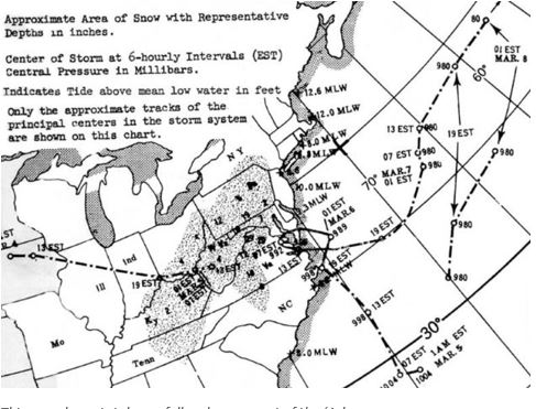 The map shows the total snowfall and motion of the ‘Ash Wednesday” storm in March of 1962. Map Credit-U.S. Weather Bureau.
According to the U.S. Geological Survey, the “Ash Wednesday Storm” was probably the most impactful East Coast winter storm in terms of coastal damage and the number of homes damaged or destroyed.
This storm has been long remembered by those who were there to experience its furious wrath.

