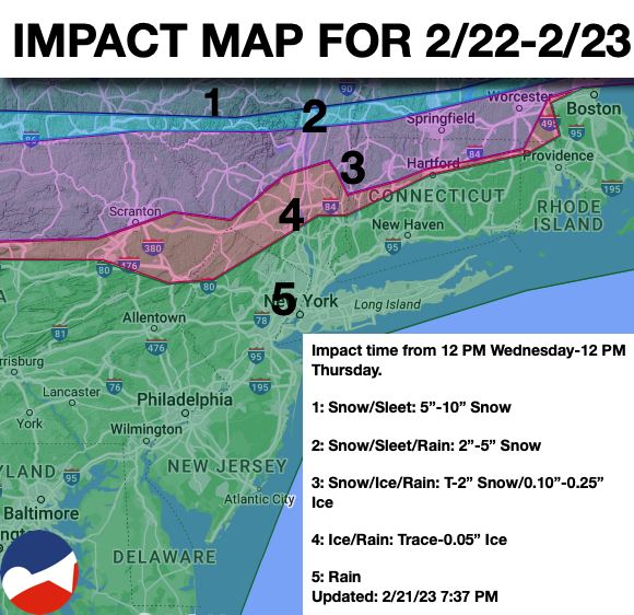
A volatile and active weather pattern will remain in place through next week with the threat of wintry mix precipitation from snow to ice to rain.
TODAY
A strong area of low-pressure and a warm front will approach the region with cloudy skies and rain for much of the region and a wintry mix of snow, sleet, and rain over the interior. Winds will be from the southwest at 5 to 15 mph. Temperatures will rise into the lower to mid-30s for elevations over 1,000 feet, mid-30s to lower 40s over the interior below 1,000 feet, and lower to mid-40s along the coast for highs.
TONIGHT
A warm front will lift through the region with periods of rain along the coast and a wintry mix of snow, sleet, and freezing rain in the Poconos, Catskills, Hudson River Valley, and northern Connecticut. Snowfall accumulation under 2″ and ice accretion of less than 0.10″ are expected. Winds will be from the south at 5 to 15 mph. Temperatures will continue to rise through the 30s over the interior and 40s along the coast.
TOMORROW
The area of low pressure will pass through the region with periods of rain for much of the region and a wintry mix of snow, sleet, and rain of the Poconos, Catskills, central Hudson River Valley, and northern Connecticut. Winds will be from the east at 10 to 20 mph. Temperatures will rise through the day with highs in the upper 30s to mid-40s in the Hudson River Valley and northern Connecticut, mid-40s to lower 50s in the New York City metropolitan area, upper 40s to mid-50s in the Poconos, northern suburbs of Philadelphia, and central New Jersey, upper 50s to mid-60s around the Philadelphia metropolitan area, and upper 60s to mid-70s in southern New Jersey.
TOMORROW NIGHT
Skies will slowly clear with a few lingering rain and snow showers. Winds will veer to the northwest at 5 to 15 mph. Temperatures will fall into the mid-20s to lower 30s over the interior and mid-30s to lower 40s along the coast for lows.
FRIDAY
High pressure will produce clear skies to scattered clouds. Winds will be from the northwest at 10 to 20 mph. Temperatures will rise into the mid to upper 30s over the interior and lower to mid-40s along the coast for highs.
SATURDAY
An area of low pressure will pass through the region with scattered snow showers in the afternoon and evening. Little if any snow accumulation is expected. Winds will be from the southeast at 5 to 15 mph. Temperatures will range from the lower to mid-10s over the interior and mid-10s to lower 20s along the coast for lows and lower to mid-30s for highs.
SUNDAY
The area of low pressure will exit with lingering snow showers that will mix over to rain. Temperatures will range from the lower to mid-20s over the interior and upper 20s to lower 30s along the coast for lows and lower to mid-40s over the interior, mid to upper 40s along the coast, and upper 40s to lower 50s in the Delaware River Valley for highs.
MONDAY
High pressure will produce scattered clouds. Temperatures will range from the mid to upper 10s over the interior and lower to mid-20s along the coast for lows and lower to mid-30s over the interior and mid to upper 30s along the coast for highs.
TUESDAY
An area of low pressure will produce periods of showers. Temperatures will range from the upper 30s to mid-40s over the interior and mid-40s to lower 50s along the coast for lows and upper 40s to lower 50s over the interior and mid-50s to lower 60s along the coast for highs.
WEDNESDAY
High pressure will produce scattered clouds. Temperatures will range from the lower to mid-20s over the interior and upper 20s to lower 30s along the coast for lows and mid to upper 20s over the interior and lower to mid-30s along the coast for highs.