

This winter has been quite mild across the Middle Atlantic region with very little snow but one of the greatest snowstorms for the region occurred forty-four years ago and I was there to experience it.
Sunday, February 18, 1979, was a bitterly cold day across the Mid-Atlantic region. Washington, D.C. was sitting in the mid-teens and clouds increased during the day. It was snowing in Charlotte, North Carolina in the morning, and by late in the day snow began to fall in the Baltimore-Washington metro area.
Initial forecasts called for a possible 4 to 6 inches across the Washington, D.C. area. There were dramatic changes in the atmosphere overnight along the East Coast and by Monday morning, much of the region was shocked when they looked out their windows at a snowfall of 18-24 inches.
Recalling Pre-Storm Events
This storm is firmly entrenched in my memory banks. I was living in Arlington, Virginia area so I got to experience this event firsthand.
The temperature was very cold on Friday, February 16th. Back then, I was a government employee and I volunteered to attend an outdoor reception at the White House where President Jimmy Carter welcomed a foreign head of state.
I had a Polaroid camera with me (the kind that the picture emerged and developed right in front of you). It was so cold that the only way that I could get the picture to develop is to place it in my leather camera holder and zip it shut.
The weekend was even colder as a reinforcing arctic cold front moved through, thanks to a massive arctic high-pressure system that kept building around the U.S.-Canadian border. I mention this because I came to learn that significant snowstorms in this region often occur when the cold air is already in place and it is fresh. If you have to bring the cold air in with the storm there will not be much, if any, snow.
This was a holiday weekend because the following Monday was President’s Day. I spent much of Sunday in the District. One of my roommates had visitors that weekend so we did a bit of sightseeing. His brother was on a college lacrosse team and he and a teammate had a game coming up in North Carolina so they were on their way down from Upstate New York.
Since they were going to the “South” they didn’t bother to take winter coats with them.
So, we all went into town on Sunday and it was bitterly cold. The temperature hovered in the middle teens, over thirty degrees below average. While we were walking around we saw many tractors parked near the National Mall.
This was part of the “Tractorcade” made up of Midwestern farmers who drove their tractors all the way to Washington to protest the “agricultural policy” of the Carter Administration. We stopped and talked to a few of them since they seemed to be friendly. These farmers and their tractors would come in handy later.
As mid-afternoon progressed, we decided that it was time to ride back to our apartment on the METRO (rail system). During our walk, we saw a homeless man wearing a cap and coat and carrying a small blanket. He proceeded to lie down on top of a grate on the sidewalk that had heat coming out of it.
I mention this because back then there was not much if any mention, of the homeless and their plight. I said to him “it’s going to snow” he said back “that’s better because when it snows it keeps me warmer.”
We made it back to the apartment and made plans to go out in the evening. as very light snow had begun to fall. We ended up going to a bar/club several miles away. I was the driver that evening but I was nervous. I knew that the snow would continue but I didn’t have any idea of the magnitude of the event that would take place over the next twelve hours. My drinks consisted of sparkling water.
As the evening progressed, I would periodically check on the falling snow that had picked up in intensity (anyone who knows me will translate “periodically” to every five minutes). Somewhere toward 9 p.m. I could see that the snow had accumulated on the cars and considering the low temperature, it was easily accumulating on the roads. I would estimate close to three inches by then.
I rounded up the others and said that we should head back to the apartment and there was no resistance. Surprisingly, the snow let up through the late evening and there were about four inches out there. Weather advisories that had been issued by the National Weather Service were canceled after midnight. We were tired and decided to go to bed.
I woke up the next morning to loud noises and yelling. I wondered what was the matter. “Come out!
… come out to the patio”! is what I heard (we were on the seventh floor overlooking the parking lot). I couldn’t believe my eyes.
There was an incredible amount of snow out there, especially for this part of the world. All that you could see in the parking lot was the shape of cars. All the roads were blocked. We weren’t going anywhere for a while unless it was on foot.
The storm on the East Coast underwent explosive development during the overnight hours and heavy snow fell from after midnight into the early morning. During the 6 a.m. hour, four inches of snow fell. There was no of official report thundersnow around the D.C. area but several people remember seeing flashes of lightning.
Storm Aftermath
I didn’t even think of finding my camera to take pictures. All we were thinking about was how we were going to dig out the cars and make some kind of path to the road. Even then, unless a plow came through, we were stuck.
We heard that a Giant Supermarket was actually open, but it was over a mile away. So, a couple of us went for some groceries. It was very tough to walk there and back. Upon return, we all found shovels, brooms, and anything that would work. We dug out some cars and tried to make a path to the street
The snow had stopped, the sun had come out and it wasn’t bitterly cold anymore. In fact, I had to take off my heavy coat and put something lighter on. The temperature approached 40 degrees that afternoon. A small plow came up the road and there was finally a way out.
It was not just us in Arlington, Virginia, who was shocked and stuck. The rest of the D.C. area was in the same boat. The only way to get around in the District was by foot or skis. The D.C. Metro (rail system had just expanded from 5 to 38 stops in the three years before the storm).
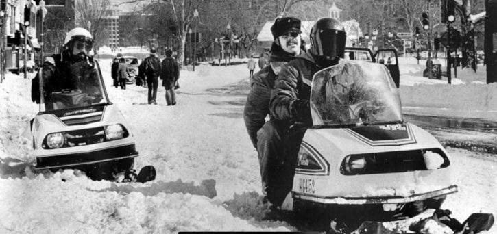
Snowmobiles were the only way to get around Washington, D.C., other than walking, after the President’s Day snowstorm in February of 1979. Photo Credit – Facebook via (Washington Weather).
Crews struggled to clear snow from the fifteen miles of track and bus service was canceled. Driving was nearly impossible with snow-covered roads with piles of snow blocking cars parked on the street. Many residents of the metro area ended up walking to get where they needed to go in the days after the blizzard.
Even though Monday was a holiday, the Federal Government was shut down for two more days.
I measured 19 inches of snow at my apartment in Arlington but at National Airport, not too far away, and the official snow total was 18.7 inches. That still stands as the third greatest snowfall on record behind only the 1922 (Knickerbocker Storm) of 28 inches and the 1899 (Valentine’s Day) storm with 20 inches.
Here is how the Washington Post described the storm – The greatest snowstorm in more than half a century left the Washington area smothered under at most two feet of snow yesterday — a magnificent white menace that virtually imprisoned the city and sent road crews battling to reopen streets for this morning’s commuters.
Some of the farmers, who I referred to earlier, attached blades to their tractors to help clear snow from the snow-clogged streets They also assisted stranded motorists.
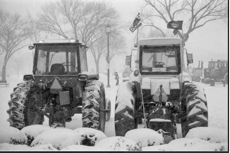
Tractors driven by farmers to Washington, D.C., as a protest, helped to clear the streets on February 19, 1979. Photo Credit- Jeff Tinsley si.edu.
This monster snowstorm also hit other parts of the Mid-Atlantic hard. Significant snow (up to a foot) fell in parts of North Carolina and Virginia. Baltimore picked up over 20 inches and Dover, Delaware, recorded about two feet.
Marty Sharrow, who was living in Owings Mills, Maryland, told me that he saw lightning and heard thunder, along with observing heavy snow, during the height of the storm!
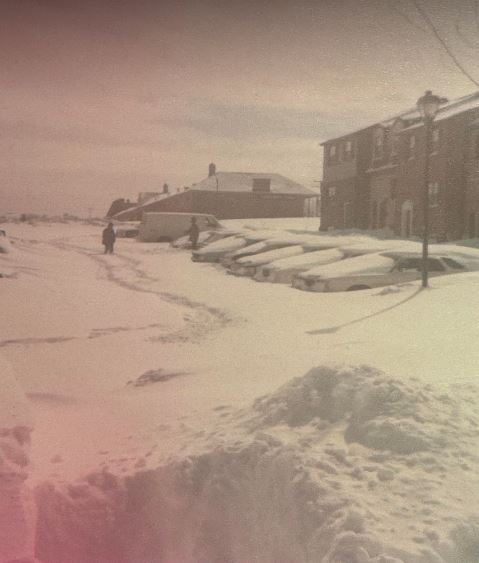
This photo was taken in Owings Mills, Maryland, following the President’s Day snowstorm in February of 1979. Up to 2 feet of snow fell around Baltimore, Maryland. Photo Credit- Marty Sharrow.
Parts of southern Pennsylvania and New Jersey also pick up double-digit snowfall. Gusty winds became more of a factor as the storm moved northward.
The storm slipped too far eastward into the Atlantic to affect the Northeast to any great degree, however. New York City received less than five inches of snow and the snow missed Boston completely.
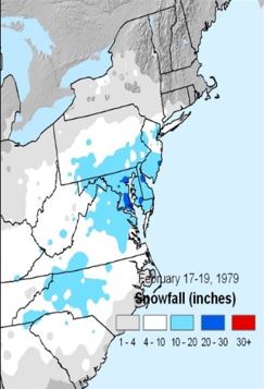
Map showing snowfall totals from the Presidents Day Storm of February 18-19, 1979 Map Credit- NOAA/NASA
Cleaning up from the storm was an arduous task. Fortunately, the warming trend that began on Monday lasted all week and more snow melted each day. A week later, there was no snow on the ground in the D.C. area.
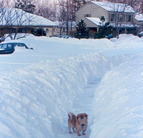
A dog finds a clear path in the mounds of snow in Annandale, Virginia on February 19, 1979. Photo Credit- flicker.com.
I had three regrets from the storm. Since my priorities were elsewhere, I amazingly didn’t take any pictures in the aftermath. Since I went to bed around midnight, I missed watching the extremely heavy snow come down. Finally, I regret not doing more for that homeless man that we saw in D.C. on that Sunday afternoon.
Meteorological Conditions – An “Epic” Forecasting Failure
During that weekend, a strong arctic high (1048 millibars) made its way down through southern Canada to the St, Lawrence Valley, so there was plenty of very cold air all the way down through the eastern U.S.
Meanwhile, a wave of low pressure formed off the coast of the Carolinas as a deepening upper-level trough was moving across the Appalachians. There was a distinct coastal trough from eastern North Carolina up through the Chesapeake Bay. This separated the arctic air from milder air from the Atlantic. As the event unfolded, it served as a lifting mechanism to enhance precipitation. Ocean temperatures were above average for the date.
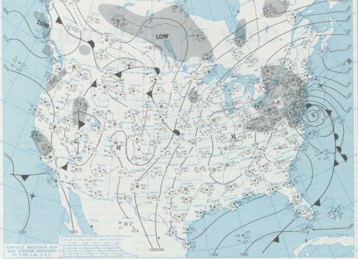
Surface weather map for 7 a.m. February 19, 1979, shows a strong low-pressure system just off the Mid-Atlantic Coast. Map Credit- NOAA Central Library.
This combination of factors and other mechanisms allowed a rather innocuous area of low pressure to strengthen rapidly during the overnight hours. Ample moisture and atmospheric dynamics allowed heavy snow to develop. Temperatures in the teens allowed the snow to accumulate rapidly.
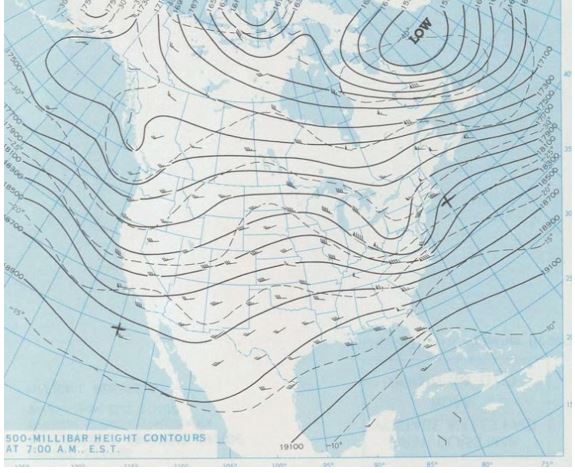
Upper-level (500 millibar) map at 7 a.m. on February 19, 1979, shows a deepening trough in the eastern U.S. Map Credit-NOAA Central Library.
One thing that is very notable about this storm is, what is now, a rather “iconic” satellite photo from February 19th. It appeared that the storm had begun to take on some tropical characteristics and the center of the low-pressure system looked like a tropical “eye”. You can see the photo as the featured image in this article.
Computer models (like the LFM) failed to predict this massive strengthening. Factors like atmospheric dynamics and higher ocean temperatures were not properly injected into the models. This was a very high-impact winter storm that was completely missed by the forecasters.
As the event was going on, the National Weather Service gave up on the storm when the snow let up and, as mentioned earlier, they dropped all winter advisories.
The forecast errors from this storm led to a more complete analysis of this event by NOAA and led to good suggestions for how computer models could be improved. Forecast failures on major events like this were no longer acceptable.
In the forty-four years since this storm, some impressive improvements have been made in the realm of weather forecasting.
There was a second President’s Day storm in 2003 that affected the Northeast, as well. That’s why the one in 1979 of often called the “first” President’s Day storm. The storm in 2003 that brought heavy snow up the East Coast was forecasted much better due to many advancements and upgrades to the “tools” that weather forecasters have to work with.
Over the past decades, there have been even more upgrades to computer forecast models like the GFS (American Model) and the ECMWF (European model) for example.


