

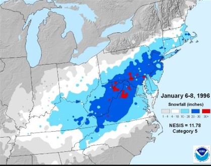
Going back 27 years, to January 6th through 8th in 1996, much of the Eastern Seaboard was struck by a major nor’ easter that wreaked havoc over a heavily populated area. The “Megalopolis” from Washington, D.C. to Boston, Massachusetts was buried by this overwhelming storm that produced 18-30 inches of snow with drifts from 5 to 10 feet high. This incredible winter storm featured blizzard conditions, strong winds, extreme wind chills, and minor to moderate coastal flooding. and many services were shut down for over a week. The event produced a whopping three billion dollars in storm damage and over 150 people lost their lives.
Amazing Snow Totals – Extreme Impacts
A low-pressure system formed in the Gulf of Mexico the morning of the 6th, moved south of Alabama the evening of the 6th, and reached Savannah, Georgia, the morning of the 7th. The center of the low moved to Cape Hatteras, North Carolina the evening of the 7th, just east of Delaware Bay the morning of the 8th, and to the southern New England coastal waters the evening of the 8th. The track of the storm was perfect for heavy snow to fall up the East Coast. An arctic high-pressure system in southern Ontario, the relatively slow movement of the storm, and ample upper-level support were other factors that contributed to the excessive snowfall.
Precipitation developed in Noth Carolina on January 6th as low pressure began to emerge from the Gulf of Mexico. In the Piedmont region, the snow was mixed with sleet at times. Hickory, North Carolina, reported a snowfall total of 14 inches from the event. Coastal areas of North Carolina reported wind gusts to 65 mph and moderate coastal flooding during high tide.
Much of Virginia received heavy snow but in West Virginia, elevation enhanced the totals. Up to 36 inches of snow fell in the Shenandoah Valley of Virginia and Pocahontas County, West Virginia picked up a whopping four feet of snow. People were trapped in their houses as snowdrifts of eight to ten feet piled up.
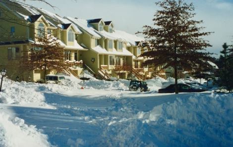
A January 1996 post-storm photo of Baltimore, Maryland, showing vehicles stranded on the street as nearly 2 feet of snow fell. Photo Credit- Robert Showver-Public Domain.
Snow spread quickly to the Baltimore-Washington, D.C. area on the afternoon of January 6th and it continued to fall into the afternoon of January 7th. The metro area picked up from 12-18 inches of snow which changed to sleet before winding down that night. Overnight, there were still periods of snow, with wind gusts to 40 mph. Thundersnow was reported on a couple of hourly observations at Dulles International Airport, west of the city.
Over two feet of snow fell at Dulles Airport, while Baltimore saw nearly 23 inches of snow. The entire metro area was brought to a standstill. Federal employees weren’t working during the event anyway because there was a government shutdown over budget squabbles, but normal operations didn’t resume for a week.
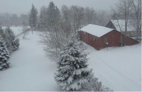
Much of Pennsylvania was buried with snow and many barns collapsed due to the weight of the snow across the state. Many supermarkets, with flat roofs, were closed.
This photo shows a collapsed barn from the weight of the snow in rural eastern Pennsylvania on January 7, 1996. Photo Credit-Flickr/mimiKa9.
Philadephia was particularly hard hit as they reported an incredible 30.7 inches of snow from the storm. That total was an all-time record snowfall for the city and it still is. The total of 27.6 inches of snow in a 24-hour period is also a record. Surrounding counties also picked up from 24 to 30 inches of snow.
The Philadelphia metro area was paralyzed by the storm. Everything was brought to a complete standstill. For three days following the storm, city trucks loaded with plowed snow dumped the snow into the Schuylkill and Delaware Rivers which eventually caused major problems with the natural flow of those rivers.

The image shows pedestrians walking on a street in Philadelphia, Pennsylvania searching for supplies during the January blizzard of 1996. Image Credit-YouTube.
In New Jersey, snow began falling on January 7th. The snow was accompanied by fierce winds, and there was considerable blowing and drifting of snow. Parts of southern New Jersey saw a changeover to sleet and freezing rain as low pressure tracked relatively close to the coast.
The town of Edison, New Jersey,y picked up 32 inches of snow (their highest total on record) while Newark was buried with 27.8 inches. Roads across the state, including the New Jersey Turnpike and Garden State Parkway, were closed as wind gusts of 50-60 mph created drifts that were overwhelming and visibilities were reduced to zero for long periods.
Thousands were without power and the state was paralyzed for at least a week. Many were also without heat. The National Guard actually had to be called to rescue police cars from their stranded vehicles.
The snow moved into New York City later on the 7th and it was relentless until the next day.
It’s a bit of a mystery to me but Central Park only recorded 20.2 inches of snow from this event. Surrounding areas recorded much more snow. Even other boroughs of New York City reported up to 30 inches of snow.
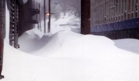
The photo shows snowdrifts blocking the streets of Yonkers, New York following the January blizzard of 996. Photo Credit-Wikipedia-Public Domain.
I was working at The Weather Channel during the event and we had Meteorologist Jill Brown reporting from Manhattan. When seeing the lower snow totals on NWS reports, I asked Jill if any sleet had mixed in with the snow and she said no. I also asked her if there was a lull in the snowfall and I got the same answer. During that time period in the 1990s, I also noticed other events where Central Park received considerably lower snowfall totals as compared to the surrounding area.

This image shows Meteorologist Jill Brown reporting for The Weather Channel in New York City during the January blizzard of 1996. Image Credit-YouTube.
New York City City schools were closed for the first time since 1978. Transportation throughout the city was severely disrupted. Buses were unable to run, and subway service was limited. Above-ground rail lines and surface bus routes were shut down for two days.
In New England, the storm was still formidable as heavy snow fell from the overnight hours, and well into January 8th Providence, Rhode, Island recorded 24 inches of snow. Boston, Massachusetts, and Hartford, Connecticut picked up 18 inches. Over 30 inches fell in the Berkshire Mountains in Massachusetts.
There were hundreds of airline cancellations from Boston to Raleigh. Rail and bus services were also closed down for days and many roads were blocked for an extended period of time.
Meteorological Conditions
There were some very interesting aspects of this storm from a meteorological standpoint. It was nearly a perfect combination of factors that came together just right to produce this major event. Below is a 500-millibar chart for the evening of January 7th, 1996.

A 500 millibar height/vorticity chart valid at 0Z January 8, 1996, shows a closed low-pressure system in the eastern U.S. Image Credit-NOAA.
In the upper levels, there was a blocking ridge of high pressure aloft around Greenland and a cold trough just north of the Canadian Maritimes. A potent upper-level trough moved into the eastern U.S. and it closed off (removed from the mail upper-level wind flow). The situation allowed the storm to move slowly up the East Coast. The upper-level pattern favored the development of intense high pressure at the surface which funneled very cold air into the storm.

Above is an (NOAA) surface weather map for the morning of January 8th, 1996. A moderately strong area of low pressure was located near the coast as it moved slowly northward. The low would turn east as it approached Long Island.
There was a strong high-pressure system in eastern Canada. It sent arctic air down from the north, while moisture came in from the Atlantic around the low. The combination not only created incredible amounts of snow and strong winds but there was an extra sharp cut off of the snow totals to the northwest.
I remember receiving a call from a TWC viewer who lived around the Catskill Mountains northwest of New York City. He was asking me about where the storm was located. There was no snow at all where he lived. As moisture moved westward into the dry, arctic air, it evaporated and areas with no snow, or very little, ended up close to areas that picked up FEET of snow.
The sharp cut-off in snow totals to the north and northwest of New York City resulted from very cold and dry air funneling into Upstate New York and New England from the arctic high-pressure system.
The blizzard of 1996 is only one of two major snowstorms that are rated a “5” (extreme) on the NESIS scale. The other is “Superstorm” in 1993. High-impact winter storms dating back to the late 1800s have been rated. The Northeast Snowfall Impact Scale was developed by Dr. Louis Ucellini and Paul Kocin (who I worked with at The Weather Channel).
NESIS has five categories: Extreme, Crippling, Major, Significant, and Notable. The index differs from other meteorological indices in that it uses population information in addition to meteorological measurements. The NESIS Scale gives an indication of a storm’s societal impacts.
I remember TWC meteorologists developing snowfall forecast maps for the event. One of our young meteorologists was creating one of these forecast maps. He called me over and said that he wanted to annotate (locally 4 feet of snow) in West Virginia but he thought that would be unprecedented and he was looking for validation. Looking at the synoptic weather conditions, I told him that if there was ever a storm that could produce four feet of snow, it would be this one. So, he stuck with his original forecast.
Events like this one are rare indeed. We have waited for 27 years for another winter storm of this type and I wonder how much longer we will have to wait.

