

A winter storm will exit the region today with improving conditions by this evening. Another storm is brewing for next week with the potential for more snow, sleet, and rain.
TODAY
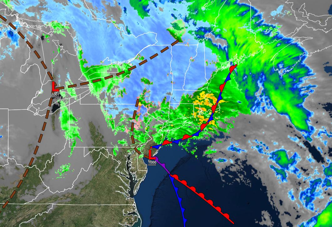
An area of low pressure will pass through the coastal waters with periods of rain, heavy at times, for much of the region while a mix of snow and sleet continues in the Poconos and Catskills. Winds will back from the east at 10 to 20 mph with gusts over 30 mph to the north at 10 to 20 mph with gusts over 25 mph. Temperatures will rise into the mid-30s in the Catskills and Poconos, upper 30s to lower 40s in the northwestern suburbs, and mid-40s to lower 50s along the coast for highs.
TONIGHT
The area of low pressure will lift into the Gulf of Maine with scattered clouds and a few lingering snow showers. Winds will back to the northwest at 10 to 20 mph. Temperatures will fall into the lower to mid-20s over the interior, upper 20s to lower 30s in the suburbs, and mid to upper 30s along the coast for lows.
TOMORROW
High pressure will build into the region with scattered cloud cover expected. A few flurries are possible in the morning. Winds will back to the west at 10 to 20 mph. Temperatures will rise into the lower to mid-30s over the interior and upper 30s to lower 40s along the coast for highs.
TOMORROW NIGHT
High pressure will produce scattered clouds. Winds will be from the west at 5 to 15 mph. Temperatures will fall into the lower to mid-10s over the interior, upper 10s to mid-20s in the suburbs, and mid to upper 20s along the coast for lows.
SUNDAY
High pressure will produce scattered clouds. Winds will be from the west at 5 to 15 mph. Temperatures will rise into the upper 20s to lower 30s over the interior and mid to upper 30s along the coast for highs.
MONDAY
High pressure will produce clear skies to scattered clouds. Winds will be from the west at 5 to 15 mph. Temperatures will range from the upper 10s to the lower 20s over the interior and lower to mid-20s along the coast for lows and lower to mid-30s over the interior and mid to upper 30s along the coast for highs.
TUESDAY
Scattered clouds are expected. Temperatures will range from the mid to upper 10s over the interior and lower to mid-20s along the coast for lows and lower to mid-30s over the interior and mid to upper 30s along the coast for highs.
WEDNESDAY
Scattered clouds are expected. Temperatures will range from the single digits to upper 10s over the interior and lower to mid-20s along the coast for lows and mid to upper 20s over the interior and lower to mid-30s along the coast for highs.
THURSDAY
An area of low pressure will develop to the south with periods of snow, sleet, and freezing rain developing throughout the region by the afternoon and evening hours. Temperatures will range from the lower to mid-10s over the northern interior, upper 10s to mid-20s in the suburbs, and mid to upper 20s along the coast for lows and upper 20s to lower 30s over the interior and lower to mid-30s along the coast for highs.
FRIDAY
An area of low pressure will produce periods of snow, ice, and rain throughout the region with significant snowfall accumulation possible. Temperatures will range from the upper 10s to the lower 20s over the interior and mid to upper 20s along the coast for lows and lower to mid-20s over the interior and upper 20s to mid-30s along the coast for highs.


