

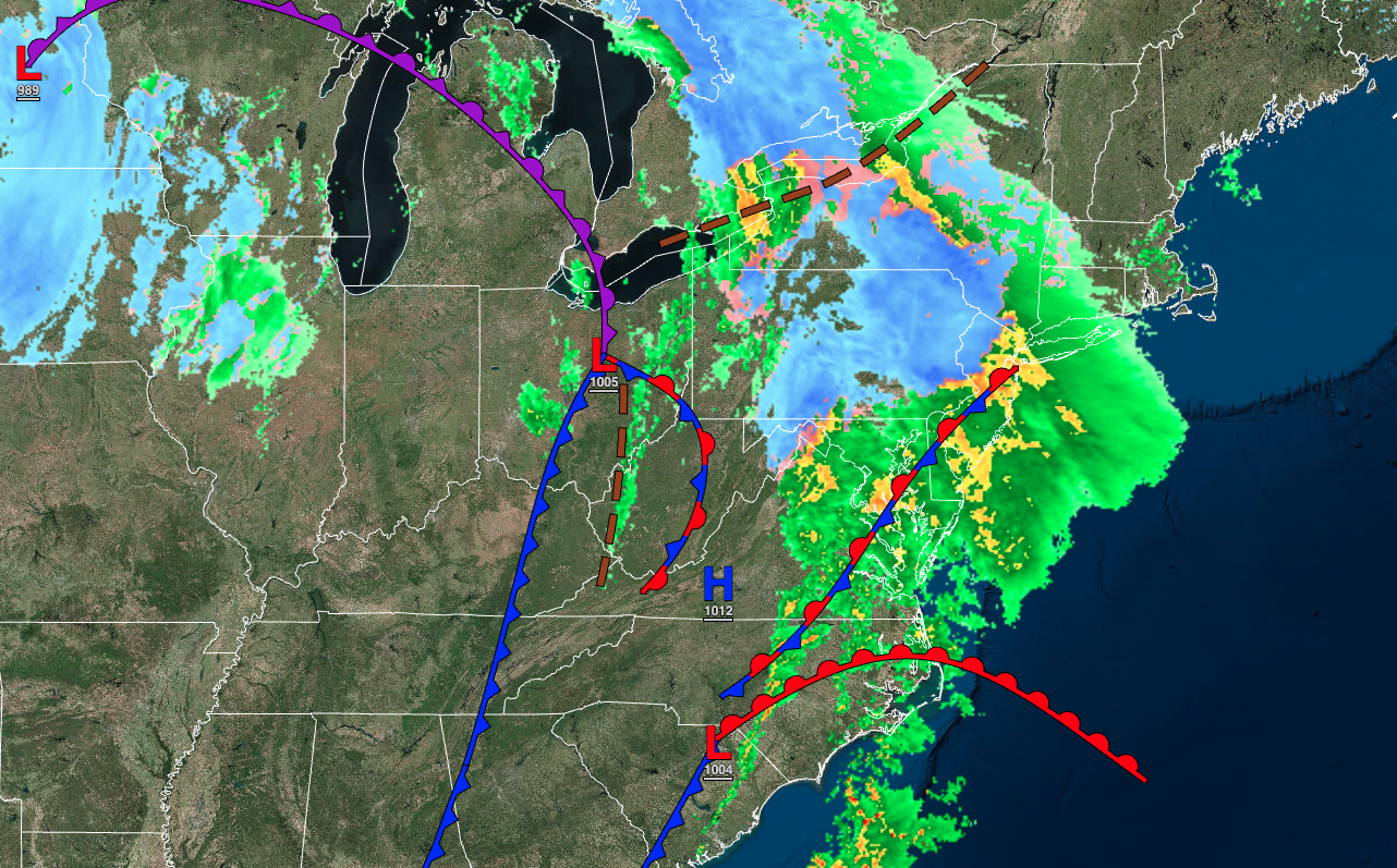
A winter storm will continue to evolve this evening with driving rainfall on the coast and heavy snow in the mountains. The potential for another major winter storm is growing for the end of next week.
TONIGHT
Periods of snow will continue in the Catskills and Poconos while a wintry mix of snow, sleet, and rain will transition to rain over the northwestern suburbs of Philadelphia and New York City. Periods of rain will continue elsewhere. Winds will be from the east at 10 to 20 mph with gusts up to 50 mph. Temperatures will hold in the lower to mid-30s in the Catskills and Poconos, upper 30s to mid-40s in the suburbs, and mid-40s to lower 50s along the coast for lows.
TOMORROW
The low-pressure system will lift toward New England with periods of snow and sleet slowly ending in the Poconos and Catskills while a wintry mix ends as snow for the northwestern suburbs of Philadelphia and New York City. The rain along the coast will taper off to snow showers by the late evening. Winds will back from the east at 10 to 20 mph with gusts up to 50 mph to the northwest at 10 to 20 mph. Temperatures will hold in the mid to upper 30s over the interior and lower 40s to lower 50s along the coast for highs and then fall through the 40s, 30s, and 20s in the evening.
TOMORROW NIGHT
The low-pressure system will begin to lift into New England with broken cloud cover and scattered rain and snow showers. Winds will back from the northeast to the northwest at 10 to 20 mph. Temperatures will fall into the lower to mid-20s in the higher elevations, upper 20s to lower 30s in the suburbs, and mid to upper 30s along the coast for lows.
SATURDAY
The low-pressure system will exit with lingering snow showers in the morning. The skies will clear in the afternoon and evening. Winds will be from the west at 10 to 20 mph. Temperatures will rise into the lower to mid-30s over the interior and upper 30s to lower 40s along the coast for highs.
SUNDAY
High pressure will produce clear skies to scattered clouds. Temperatures will range from the upper 10s to the lower 20s over the interior and mid to upper 20s along the coast for lows and upper 20s to lower 30s over the interior and mid to upper 30s along the coast for highs.
MONDAY
High pressure will produce clear skies to scattered clouds. Temperatures will range from the upper 10s to the lower 20s over the interior and lower to mid-20s along the coast for lows and lower to mid-30s over the interior and mid to upper 30s along the coast for highs.
TUESDAY
Scattered clouds are expected. Temperatures will range from the mid to upper 10s over the interior and lower to mid-20s along the coast for lows and lower to mid-30s over the interior and mid to upper 30s along the coast for highs.
WEDNESDAY
Scattered clouds are expected. Temperatures will range from the single digits to upper 10s over the interior and lower to mid-20s along the coast for lows and mid to upper 20s over the interior and lower to mid-30s along the coast for highs.
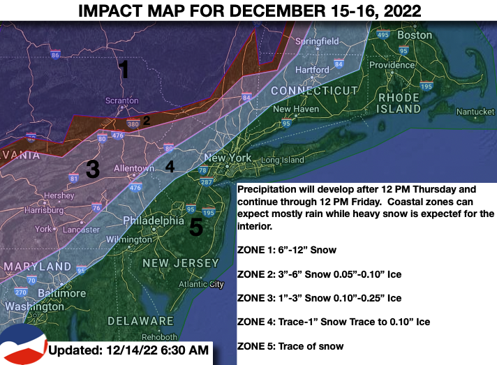
THURSDAY
An area of low pressure will develop to the south with periods of snow, sleet, and freezing rain developing throughout the region by the afternoon and evening hours. Temperatures will range from the lower to mid-10s over the northern interior, upper 10s to mid-20s in the suburbs, and mid to upper 20s along the coast for lows and upper 20s to lower 30s over the interior and lower to mid-30s along the coast for highs.
FRIDAY
An area of low pressure will produce periods of snow throughout the region with significant snowfall accumulation possible. Temperatures will range from the upper 10s to the lower 20s over the interior and mid to upper 20s along the coast for lows and lower to mid-20s over the interior and upper 20s to lower 30s along the coast for highs.


