

The most devastating storm of the 19th century occurred around Great Britain from the evening of October 25th through October 26th of 1859. The Royal Charter Storm, as it was called, referred to the name of a steamship that was driven into the east coast of Anglesey, Wales, where it was torn apart by rocks, hurricane-force winds, and storm surge. Over 450 lives were lost on the Royal Charter. Another 130 ships were wrecked in this storm of fury.
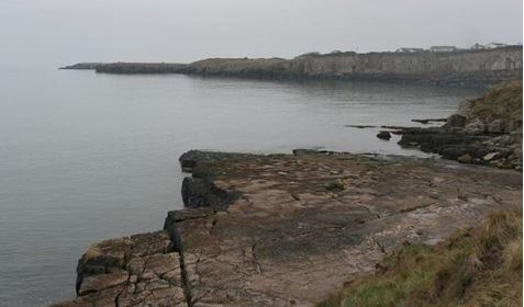
This photo shows the rocks along the east coast of Anglesey, Wales where the Royal Charter was broken up on October 26, 1859. Photo Credit-Facebook
A British naval captain and scientist, Robert FitzRroy was convinced that these storms could be detected ahead of time and some kind of warning could be issued. His dogged determination led to the development of a gale warning service from the Meteorological Office and it led the way to better analysis and communication of storm information and eventually to the establishment of government weather information services in the U.K. and around the world.
An Embarrassment of Riches
In 1859, a few hundred (seekers of fortune) embarked on a trip from Great Britain to Australia hoping to bring back some riches from the newly discovered Australian gold fields. At the end of August, a bounty of gold was loaded onto the Royal Charter for the voyage back to Great Britain.
The Royal Charter was the pride of Britain’s cargo fleet weighing over 2,700 tons with 200 horsepower. It could complete the journey from Melbourne, Australia, around the Cape of Good Hope, to Liverpool, England in just 58 days. The ship was reproof, waterproof, and iron tight. The amount of gold loaded onto the ship had an estimated worth of 500,000 pounds (tens of millions of dollars today).
So, with a total of 324 passengers, and a crew of 103, The Royal Charter left Melbourne, Australia for a trip to Liverpool, England, that would take less than two months.
Many of the gold seekers had indeed found plenty of it and they stuffed it into their pockets, clothing, and suitcases. Some passengers sewed gold into their clothes. British commoners would suddenly be rich, they would be able to purchase the best clothing and shop in the most upscale stores. It almost seemed too good to be true.
A Cruel Twist Of Fate
The trip home was described by some passengers as a “journey of pure bliss.” Many passengers were able to procure luxury cabins with their newfound gold. Others dreamed of what it would be like to live what the French called the “bon vivant”. Near the Cape of Good Hope, the ship passed extremely close to an iceberg but the crew was able to avoid it.
The Royal Charter was on its final leg as it was set to pass around the northwest tip of Anglesey (an island off the northwest coast of Wales). In the early evening of October 25th, weather conditions began to change and they did so in a hurry. The wind began to pick up rapidly and the barometric pressure fell rapidly. The ship’s Captain, Thomas Taylor was advised to move the ship to Holyhead Harbor for temporary shelter.
Captain Taylor made what would be a fatal mistake. He chose to move on toward Liverpool with a bounty of gold but the fates would not allow it. By 10 p.m. the wind was blowing over 40 mph and it had shifted to the northeast. He made a decision to drop two anchors at 11 p.m. but by midnight the ferocity of the wind was exceeding hurricane force. The Captain ordered that the masts be cut to reduce the drag of the wind and he sent up distress signals. These moves were useless because the signals weren’t seen and time was evaporating. The ship was too close to the coast and the lines holding the anchors were ripped apart by the wind.
Despite cutting the masts to reduce the drag of the wind the Royal Charter was driven toward the shore and her steam engines were unable to make headway against winds that exceeded 100 mph at times. The doomed ship struck the rocks at Point Alerth while being battered by huge waves and it quickly broke up early in the morning of October 26th.
Most of the passengers were overwhelmed by the suddenness and the ship’s destruction. Some were instantly killed by being thrown against the rocks.
Krista Lysack described one account of a survivor which was published by bradcollective.org “Time passed anxiously and wearily; the storm still raged. Suddenly the vessel struck, not violently, not even with sufficient force to throw the passengers off their seats but water came pouring down into the cabin.”
Intense surges of the water drowned many passengers instantly. In the early morning, townspeople gathered near the site of the wreck. Many risked their lives forming human chains just offshore with ropes tied to their belts in an attempt to rescue some survivors. They were able to save a few and remarkably, a few made it to shore. No women or children survived, however. All 41 survivors were men but all of the ships of officers perished. Apparently, the women and children were told to stay below the deck just before the ship hit the rocks and was torn apart. All of this carnage occurred just 70 miles short of the Royal Charter’s destination of Liverpool.
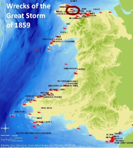
This map indicates shipwrecks that were a product of the Royal Charter Storm in October of 1859 (the Royal Charter location is circled). Map Credit-blogspot.com
Meteorology Takes A Leap Forward
The storm was an incredible tragedy and it was likely the worst storm of the 19th century in that area. In addition to the Royal Charter, there were over 130 other ships that were damaged along the west coast of Britain, and another 90 were seriously damaged.
There was one man, Robert Fitzroy who was convinced that storms like this could be tracked better and a system of communicating life-saving information could be enacted.
 A photo of Robert FitzRoy – Head of the department for meteorological statistics in the 1850s. Photo Creditnatlibgovt,nz-Public Domain
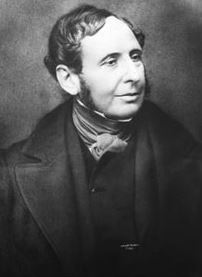
Robert FitzRoy was a British naval officer who had been the captain of the MHS Beagle. In 1853, he was appointed as an advisor to the Board of Trade, which later became the Meteorological Office. He then became head of a newly created department for meteorological statistics.
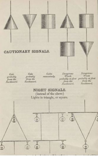
After the storm, FitzRoy conducted a detailed analysis of the tragic event and presented his conclusions to the British Association for the Advancement of Science in 1860. Among his recommendations was to enact a storm warning system which would be comprised of a set of visual signals that could be communicated from shore to ship. The information would be communicated by a system of various cones and cylinders which would be raised on pulleys.
 This image shows an example of Robert FitzRoy’s symbols used in the coastal warning system for storms. Image Credit-U.K. Met Office.
Mr. FitzRoy was interested in the progress of Meteorology as a science and how meteorological data could be obtained and communicated to those who needed it.
One of his ideas was to lend meteorological instruments to ship captains in order to gather weather information over large areas. This data could help scientists to understand the formation and motion of cyclones which some scientists were already studying. A storm warning service was subsequently added to the Met Office.
FitzRoy wanted the information to be used by mariners and others in addition to the new warning system. He also promoted the use of the telegraph in communicating weather information before and after a storm struck.
After Fitzroy’s death in 1865, the storm warning service was discontinued due to the ongoing debate in the British Parliament about its scientific accuracy of weather forecasts and if meteorology was indeed a science. After a public outcry and a campaign in newspapers, the storm warning service was restored in 1867. The service continues to this day and is now known as the “Iconic Shipping Forecast”.
Meteorological Conditions – October 25-26, 1859
The U.K. Met of Office produced a re-creation of the Royal Charter storm based in part on observations that were recorded on a map by FitzRoy. The first reports of the developing storm came from the Bay of Biscay on October 24th. The storm continued to move north toward the British Isles on the 25th and it strengthened rapidly.
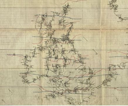 This image shows a map of meteorological observations that was produced by Robert FitzRoy during the Royal Charter Storm in October of 1859. Image Credit-U.K. Met Office
As mentioned earlier, winds rapidly increased along the coast of Wales during the evening from 40 mph in the early evening to hurricane-force by 10 p.m. After midnight, the wind speed in some locations exceeded 100 mph. Hurricane-force winds continued all night and into the morning of the 26th with the prevailing direction from the northeast.
The central pressure of the storm likely dropped to near 980 millibars. To the northwest, there was a building area of high pressure moving southeastward from Iceland so there was a significant pressure gradient. The storm was a slow-mover which allowed the wind to remain very strong for a long period of time. That sealed the fate of the Royal Charter. The storm moved into the North Sea and clipped Scotland before reaching Norway on October 27th.
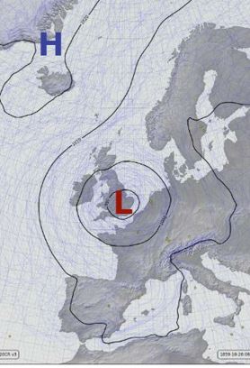 This surface weather map is a re-creation of the Royal Charter Storm on October 26, 1859. Map Credit-UK Met Office,
Odds and Ends
The total number of deaths from this beast of a storm exceeded 800 when all was said and done. There was extensive structural damage to many buildings, with the west coast of Great Britain taking the brunt of the storm The remains of the church of St. Brynach be seen at CWM-yr-Ehlys at Pembrokeshire.
A memorial, created by the sculptor Sam Holland was unveiled in 2009. The Royal Charter Memorial is situated in the churchyard of St Allgo’s church. It commemorates the Royal Charter disaster with the loss of more than 400 lives on the coast nearby on the night of 25-26 October 1859. An adjacent cemetery includes over 100 of the dead from the storm. The dead bodies were treated with the utmost respect and their possessions and clothing were returned to family members when possible.
Ten years later, British novelist Charles Dickens wrote an account of the Royal Charter wreck and how the tragedy affected the surrounding towns. It was called ‘The Shipwreck” and it was featured in the Publication “All Year Round”. Dickens indicated how shocked he was to actually see the ruins of the ship.
Bodies continued to wash up along the coast for weeks after the storm. Many of them had gold in their clothing and those who found the bodies took the gold. The local government set up an office in the area Town Halls where you could bring the gold and they would give you a receipt. I would imagine that many skipped that step.
Bounty hunters arrived at the site of the wreck for decades to search for gold. Bits of gold is still being found to this day.
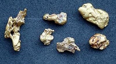 The photo shows gold nuggets from the wreck of the Royal Charter that is still being found to this day. Photo Credit- Facebook
During that same time period, across the Atlantic, there were an alarming number of shipwrecks around the Great Lakes in the United States. The U.S. Government followed the lead of Great Britain and took action.
In 1870, President Ulysses S, Grant signed a resolution allowing the secretary of war to set up a national weather warning service. The original purpose of the service was to facilitate the collection of weather data from military installations located across the country and warn locations along the Great Lakes and marine coasts of major storms. In the early days of the service, weather information was relayed by telegraph to Washington, D.C.
Ironically, there were some members of the U.S. Congress who questioned meteorology as a science and that storms could actually be forecast (very similar to what went on in Great Britain). There were battles over funding for the new weather warning service for a significant period of time.
 This photo shows a modern-day National Weather Service office in the U.S. Photo Credit-www.weather.gov.
Eventually, the initial warning services in the two nations evolved into the National Weather Service for the U.S. and the U.K. Met Office which we have today.

