

During the first week of October, one hundred and fifty-three years ago, a hurricane raced up the U.S. Eastern Seaboard, making one landfall on Cape Cod, Massachusetts, and another on coastal Maine. The storm dumped impressive amounts of rain from Virginia to Atlantic Canada and it triggered extraordinary and deadly tidal damage in the Canadian Maritimes.
It would be over 80 years before hurricanes were officially given names, yet this one was. Today, in 2022, hurricane forecasts have improved markedly in the 3 to 5-day period, yet this one was commonly believed to have been forecast nearly ten months in advance over 150 years ago. How can that be? There’s a story to be told, so let’s go way back in time.
The Forecast?
In 1868, Stephen Martin Saxby was a lieutenant in the British Royal Navy and was known as an amateur astronomer. He often claimed that storms could be predicted by the phases of the moon combined with the distance the moon was from the earth at a given time. He sometimes referred to his work as “astrological meteorology”.
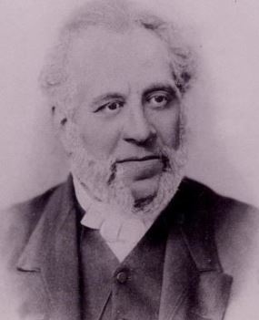
A photo of Lieutenant Stephen Martin Saxby in 1870. Credit: Albert County (NB) archives.
A letter that he had written to the Standard of London, a popular newspaper, was published on Christmas Day in 1868. Here is what Lieutenant Saxby wrote.
I now say to the state, with regard to 1869, that at seven a.m., on October 5, the moon will be at that part of her orbit which is nearest to the earth. Her attraction will, therefore, be at its maximum force.
At noon of the same day, the moon will be on the earth’s equator, a circumstance which never occurs without mark atmospheric disturbance, and at two p.m. of the same day lines drawn from the earth’s centre would cut the sun and moon in the same arc of right ascension (the moon’s attraction and the sun’s attraction will therefore be acting in the same direction); in other words, the new moon will be on the earth’s equator when in perigee, and nothing more threatening can, I say, occur without a miracle.”
On September 16, 1869, he wrote the following:
“One is justified in expecting (to say the least) quite as great an atmospheric disturbance early in October. Warnings apply to all parts of the world; effects may be felt more in some places than in others. It is painful to have to forebode evil, but better thus than to merit self-reproach under circumstances which might lead to permanent regrets.”
Should there be a coastal storm at the same time then the effects might be profound, The Bay of Fundy, between New Brunswick and Nova Scotia, Canada, has the highest tidal range in the world, and this was exacerbated not only by the spring tide but also by the hurricane’s storm surge funneling up from the southwest.
Frederick Allison, a Halifax, Nova Scotia Meteorologist, read Lt. Saxby’s warning. On September 30, 1869, Mr, Allison wrote to the editors of the Halifax Evening Express to make a reference to Saxby’s letters. He took Saxby’s hazy warning with regard to a set location and focused his concern on the Canadian Maritimes.
Here is what Meteorologist Allison wrote :
“I believe that a heavy gale will be encountered here on Tuesday next, the 5th Oct., beginning perhaps on Monday night, possibly deferred as late this Tuesday night; but between those two periods, it seems inevitable. At its greatest force, the direction of the wind should be South West; having commenced at or near South. Should Monday, the 4th, be a warm day for the season, an additional guarantee of the coming storm will be given. Roughly speaking, the warmer it may be on the 4th, the more violent will be the succeeding storm…..Telegrams from points to the South West of us might give notice of the approach of this storm, and I trust this warning will not be unheeded.”
It’s unclear whether Mr. Allison was aware of an approaching tropical cyclone. He did refer to the “warmth” which often comes in tandem with tropical events. According to ship reports, There was some tropical activity in the western Atlantic and Caribbean in late September. There was a strong Atlantic storm reported on the evening of October 3rd, north of the Bahamas.
The storm was actually a hurricane by then but the term wasn’t commonly used to describe tropical cyclones at that time. The hurricane moved rapidly to the north-northeast and it was already approaching Nantucket Island and Cape Cod by midday on October 4th.
Saxby Gale (Hurricane) Track and Impacts
The first report of this hurricane was by a ship that estimated winds up to 105 mph, a Category 2 hurricane on the Saffir-Simpson Scale. It then tracked rapidly to the northeast.
The hurricane produced heavy rain from Virginia to Maine, with a report of 12.25 inches at Canton, Connecticut. After passing just west of Nantucket, it made its first landfall on Cape Cod later in the day. Cape Cod was sparsely populated then with only a smattering of farms at that time.
The strongest winds were on the east side of the hurricane with hurricane-force winds reported at Nantucket. In Boston and Worcester, winds were reported in the 20-30 mph range so the area was spared wind damage. The winds remained strong as it made a second landfall just above Portland, Maine.
Hurricane-force winds were reported over the upper coast of Maine. Lisbon, Maine reported gusts well above 100 mph. The reason for that is likely because the hurricane had interacted with a midlatitude storm approaching from the west, but more on that later. Washington and Hancock Counties reported extensive tree and property damage.
Here is a report from the Eastport (Maine) Sentinel :
“This town was visited by a fearful hurricane last night, vessels, wharves, stores, and houses were smashed to atoms. …Twenty-seven vessels are ashore in Rumney Bay….The schooner Rio was lost in St. Andrews Bay with all on board—17 in number….Grand Menan is swept with all its weirs and smokehouses. The towns of Lubec, Pembroke, and Perry lost heavily.”
The most severe impacts were felt in Atlantic Canada, however.
After a calm morning, rain began to fall at Saint John, New Brunswick. During the evening winds reached hurricane force with its maximum velocity at about 9:00 p.m. Wind gusts were estimated up to 125 mph.
The storm downed hundreds of trees that blocked roads and railways with debris. Hundreds of boats were beached due to the high winds all along the Fundy Basin. The first Roman Catholic Church in Cork, New Brunswick, completed in 1861, was destroyed.
The greatest impact was from water, however. The storm (likely post-tropical) raced up the Bay of Fundy on October 5th at the time of the normal high lunar tide, thus adding the destructive storm surge to the high tide.
The combined astronomical tide and a nearly 7-foot storm surge drove waters in the Bay of Fundy to record heights, the high water mark reaching nearly 71 feet. The waters rose to 58.5 feet at the Burncoat Head Lighthouse in Hants County, Nova Scotia. Average normal tides there are the highest tides in the world.
The towns of Maitland, Amherst, Truro, and Great Village, Nova Scotia in the Minas Basin, and Sackville and Moncton, New Brunswick up from Chignecto Bay suffered significant flooding, but catastrophic flooding occurred in southern New Brunswick and northern Nova Scotia.

This painting depicts rising tidal waters surrounding a farmhouse in New Brunswick during the 1869 “Saxby Gale”, Credit-Albert County (NB) archives.
According to personal descriptions, wharves were turned into “matchsticks”. Hundreds of boats were washed onshore and destroyed. The letters of Lieutenant Saxby’s predictions were recalled and the name “Saxby Gale” was bestowed upon this ferocious storm.
The Halifax (Nova Scotia) Chronicle wrote this about the “Saxby Gale” on October 8th :
“About 11:00 o’clock Monday night four dykes at Poverty Point, near Smith Island, gave way and ten minutes afterward the lowlands for miles around were flooded, and their contents much damaged. The inmates were compelled to take refuge in the upper stories. Many cattle and sheep were drowned. Mr. P. Miles lost 34 sheep. The tide rose four feet higher than it was ever known before! At Falmouth and Newport, the dykes were carried away, and the land flooded. At Horton, and upon the Grand Pre dykes, a quantity of hay was destroyed and numbers of cattle drowned, some of which drifted out to sea. Bridges were carried away or destroyed.”
All told, more than 70 people and numerous farm animals had drowned in Canadian Maritimes. It is conjectured that the death toll was much higher, however, with many people swept away by the tide and unaccounted for. Other fatalities were caused by ships sinking, such as the sailing ship Genii with the loss of eleven lives.
Meteorological Conditions
The event looks like one that you would see in October, with a tropical cyclone being influenced by a mid-latitude trough and the storm accelerated to the north and northeast.
As with most October tropical cyclones, it was not likely a “Cape Verde” storm (with its roots tracing back to African Coast). It probably formed somewhere between Hispaniola and the Bahamas.
There were meteorological reports of a cold front passing through New York State on October 4th so it looks like the “Saxby Gale” indeed was influenced by a mid-latitude trough that allowed it to accelerate quickly to the north-northeast. With the trough aloft, there would be an area of low pressure at the surface, with an attending cold front.
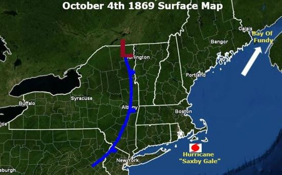 A morning surface weather map (my best guess) was valid on October 4, 1869 (based on meteorological reports).
Energy from the mid-latitude system probably interacted with and enhanced the tropical system so the “Saxby Gale” was likely a “hybrid” storm by the time it reached New England (and a reason why the winds remained so high all the way into Canada).
The Bay of Fundy is notorious for its incredible tide cycles, and with the track of the storm to its west, an incredible amount of water was funneled into it, making it a deadly (almost surreal) situation.
Conclusion
Lieutenant Saxby did have some knowledge of astronomy but he wasn’t a meteorologist. His letter nearly ten months in advance of the event in question was correct in pointing out that there could be a storm with devastating tidal or storm surge in early October of 1869. That was easier to conclude because the moon phase and potential enormous tidal surge could be known at the time. His letter was short of specifics, especially the location.
To his credit, Saxby was more specific in his letter that was written in mid-September of 1869. He had no way of knowing, but IF an intense storm approached the Canadian Maritimes in early October, it had the chance to be catastrophic. Intense mid-latitude storms and tropical cyclones are not foreign to that part of the world in October. There were some who believed that Lt. Saxby had a premonition or he featured some kind of psychic ability. Saxby’s ominous forecast was basically what could happen in the part of the world if a storm of that magnitude moved into the region. Predicting the exact date (within a day) was likely a combination of some knowledge and a stroke of luck!
There is the forecast, however, the forecast of Fredrick Allison, who WAS a meteorologist. Was he aware of a tropical system on September 30th that could possibly track toward the Canadian Maritimes? Remember that he knew of Saxby’s prediction so perhaps he put “2 and 2” together. Or, he feared what would happen IF a storm came his way in early October and wanted to reiterate what Saxby had written.
The name “Saxby Gale” stuck and this event is still referred to by that name in history books and journals. If Mr. Allison did know about the impending hurricane and made the forecast days in advance, perhaps the “Saxby Gale” should have been named after Mr. Allison.


