

Residents of cities like New London, Connecticut, and Providence, Rhode Island woke up to a breezy but pleasant Wednesday on September 21, 1938. They went on about their day at work and school like many other days. Little did they know that within just a few hours, many of their lives would be changed forever and for hundreds of others, it would be their final few hours as an intense hurricane would be arriving unannounced.
This impending hurricane would be one of the greatest U.S. weather disasters on record. It literally took residents of Long Island the New England by surprise. Depending on where you lived some called it the “Long Island Express” or the “Great New England Hurricane”. All told, there was incredible widespread damage in addition to the deaths and injuries Worst of all, it took everyone by surprise.
If there was a Hall of Fame for hurricanes, this one would be right up there. The strongest hurricane to slam the Northeast U.S. on record.
A “Classic” Cape (Cabo) Verde Storm
The technology for forecasting tropical weather systems was primitive in 1938. There were no satellites or computer models to track ocean storms or hurricanes. A reanalysis of the 1938 hurricane indicated that it was borne out of a tropical wave that emerged off the coast of Africa. This feature developed into a tropical depression near the Cape (Cabo) Verde Islands on September 10, 1938.
On September 16th, the captain of a Brazilian freighter radioed the U.S. Weather Bureau in Puerto Rico to inform them about a tropical storm in the Atlantic at Latitude 21 N Longitude 52W.
On September 18th the storm was centered north of Puerto Rico. By September 19th, what was thought to be a tropical storm was centered over 600 miles east-southeast of Miami, Florida (by that time, it was likely a Category 5 hurricane with maximum sustained winds near 160 mph)! The general consensus was that the tropical storm would move toward Florida and storm warnings were issued by the U.S. Weather Bureau in Jacksonville, Florida, from Key West to Jacksonville.
On Tuesday, September 20th a cold front was approaching New England resulting in rain and fog.
There was increasing concern about river flooding with heavy rain that was being produced ahead of the front. Meanwhile, what was now a strong hurricane had turned more to the north and it would be passing well east of Florida.
By early afternoon, the hurricane was centered around 350 miles east of Daytona Beach, Florida. The Jacksonville Weather Bureau indicated that the hurricane would move more rapidly and that it could turn more to the northeast.
By evening, the Jacksonville Weather Bureau mentioned a “severe” hurricane with a central pressure of 28.00″ (948 millibars). Storm warnings were extended up to Atlantic City. The size, strength, and forward speed of this hurricane would continue to be vastly underestimated until it made landfall.
After midnight, the hurricane was centered a little more than 200 miles south of Cape Hatteras, North Carolina.
Zooming Northward To Landfall
By the morning of September 21st, the hurricane was centered nearly 150 miles northeast of Cape Hatteras. No hurricane alerts were issued north of Atlantic City. Under the influence of an upper-level trough that was swinging into the eastern U.S., the hurricane began to accelerate rapidly. It has very little time to weaken over cooler water before landfall on Long Island. Its estimated forward speed was greater than 45 mph.
Over the years, I had a chance to speak with a couple of people who experienced this hurricane. Neither was in the worst of it but both experienced some impacts of wind, rain, and flooding. They were both going to school well inland in New England then and they were unaware of any weather problems. On their way home, the wind and rain increased rapidly as weather conditions went downhill in a hurry. Here is a timeline that was published by the National Weather Service in Upton, New York.
9:00 AM
The U.S. Weather Bureau at Washington, D.C. takes over and issues northeast storm warnings north of Atlantic City and south of Block Island, and storm warnings were issued from Block Island to Eastport, Maine. This advisory called the hurricane a tropical storm and they had it centered 75 miles from Cape Hatteras. It was actually further away from Cape Hatteras than written in the advisory. The storm was also much larger and stronger than anticipated.
The U.S. Weather Bureau in New York City has not received a single piece of information about the exact location or strength of the storm.
The New York Times in their early edition mentioned that a severe hurricane had spared the Florida East Coast and it apparently had turned out to sea.
11:00 AM
The hurricane is now about 200 miles due south of Fire Island. A strong southerly wind was apparent in Vermont and farmers mentioned the smell of sea salt in the air.
The Washington, DC Weather Bureau issued an advisory with no mention of a hurricane or tropical storm. They mentioned that gale force winds will be likely and diminish overnight.
12:00 PM
The hurricane is located about 100-120 miles SE of Atlantic City and about 150 miles south of Fire Island. It was actually racing to the north at 40-50mph!
1:00 PM
Conditions are beginning to deteriorate from NYC to the east end of Long Island. The pressure is dropping rapidly, winds are increasing and waves are building. Connecticut was still more concerned about the intense river flooding because of the hurricane.
2:00 PM
An advisory from Washington, D.C. mentions that the storm is about 75 miles east-southeast of Atlantic City. It mentions that the storm will pass over Long Island and Connecticut this afternoon. Reanalysis shows that the storm may have actually been about 120 miles southeast of the city and much stronger and bigger than was mentioned in the advisory. It was now about 50 miles south of Cherry Grove, NY, on Fire Island.
Hurricane gusts are already occurring over Fire Island and along the south shore of Long Island.
The Connecticut shore was experiencing gusts near 75 mph as well.
In New York City, children were let out of school early. Heavy rains were occurring, trees were falling and power lines were falling down.
In Saltaire, NY, on Fire Island, the boardwalks were being ripped and tipped over. Nobody was evacuated before the storm so many people on Fire Island were rushed into the shelter. On the south shore of Long Island, debris was flying, phone lines were dead and power was out. In Connecticut, winds were not as strong but the pressure was rapidly falling. Flooding was still the main concern.
On the Long Island Sound, a Port Jefferson ferry had left at about 1:00 pm, heading to Bridgeport, CT. Conditions deteriorated so rapidly that the ferry could not continue, nor turn back. All 15 passengers on board were safe.
The 1938 hurricane landfall was near Bellport, NY sometime between 2:35 and 2:45 pm EST as a Category 3 with an approximate pressure of 27.79 in (941 millibars) and 120 mph maximum sustained winds (Landsea et al. 2013).
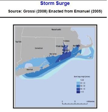
Because the hurricane was moving so rapidly, weather conditions changed suddenly. A partly cloudy breezy day turned horrific in a hurry with hurricane-force winds from the eastern half of Long Island to Connecticut and Rhode Island. As we will see later a massive storm surge (over 15 feet in Connecticut and Rhode Island) swallowed up most buildings and homes in coastal areas.
Widespread And Incredible Destruction
Before landfall, the hurricane passed just east of New Jersey. Coastal areas received tropical storm-force winds and a storm surge. The Brigantine Bridge over the Absecon Inlet was destroyed. The Atlantic City boardwalk was destroyed as was the boardwalk at Wildwood as the town was under 3 feet of water at one point. A wind gust of 70 mph was recorded at Sandy Hook. Dozens of cottages along the shore were destroyed.
Eastern Long Island took the brunt of the hurricane’s fury. Around 2:40 p.m., the full force of the hurricane made landfall at high tide. Ocean water and waves engulfed roads and homes. At Westhampton, 150 beach homes were destroyed, about a third of which were pulled into the ocean. Winds exceeded 100 mph.
Many people had to fight hard just to stay alive. Some survivors who were in homes that were swept away held on to mooring or boards as they were swept into the ocean and then back to shore. Others climbed to the roof of their homes.
There were fifty deaths in Port Jefferson due to high winds and storm surges. Incredibly, ten new inlets were created on eastern Long Island as a result of the hurricane. Many bridges on Long Island have washed away and that severed train service between New York and Boston and between cities in Connecticut and Rhode Island. It brought down 20,000 miles of power and telephone lines.

This photo shows the magnitude of storm surge damage inflicted by the 1938 hurricane at Fire Island, New York. Photo Credit-U.S. Army.
Inland, many people were drowned in flooding, killed by uprooted trees and falling debris, and electrocuted by downed electrical lines. Twenty-nine people lost their lives at Westhampton, New York. Twenty-one others perished in other sections of Long Island. Montauk was turned into an island. The storm surge was up to 15 feet.

This photo shows the incredible damage produced by the Great Hurricane Of 1938 on eastern Long Island. Image Credit- YouTube – Public Domain Footage.
There was less damage on the western side of the hurricane but Central Park in New York City recorded a gust of 80 mph and Battery Park gusted to 90 mph. A wind gust of 125 mph was recorded at the top of the Empire State building! Trees were down all over the city and there was a widespread loss of power. Floating debris blocked drains and that resulted in street flooding. Transportation services were taken down until the next day. A Con-Ed power plant was flooded Just east of the city, and 95% of customers lost power in Nassau County.

The combination of heavy rain and clogged drains from the 1938 hurricane turned many New York City streets into rivers as seen in this image. Image Credit- YouTube-Public Domain Footage.
Many sections of New England were left in ruins. The hurricane eroded roadbeds. It washed away railroad tracks, sent bridges downstream, and downed electrical wires, leaving some New Englanders without electricity for weeks.
In Connecticut, the eastern half of the state, on the east side of the hurricane, sustained the most damage. There was extensive destruction to towns along the shoreline, especially east of New Haven. Most coastal homes were reduced to ruins. This incredible hurricane remains Connecticut’s worst natural disaster. The 14.1-foot storm surge at Stamford is still the highest on record for the state. A passenger train was stuck in debris at Stonnington. Along the shore, buildings were swept off of their foundations and later found two miles away! In Mystic, shells and crabs were found in cabinets as rescuers searched for survivors.
A passenger train was stuck in debris at Stonnington. Along the shore there, buildings were swept off of their foundations and later found two miles away! In Mystic, shells and crabs were found in cabinets as rescuers searched for survivors.
Not only did New London suffer from extreme wind and storm surge but the business district caught re and it burned for ten hours. There was widespread wind and flood damage inland as rivers over owed their banks. Severe flooding was reported at Hartford along the Connecticut River.

This photo shows reconstruction that started in the wake of the Great New England Hurricane Of 1938 which destroyed the business district of New London, Connecticut. Image Credit- YouTube-Pubic Domain Footage
Because the state was on the east, or strongest, side of the hurricane, Rhode Island suffered massive damage from the wind and storm surge from the 1938 hurricane. Just before 4 p.m., a massive storm surge hit Westerly and it killed 100 people. The full moon and high tide exacerbated an already terrible situation with the storm surge.
Hundreds of summer cottages were swept away by the fierce storm surge. The surge was funneled up through Narraganset Bay. Winds exceeding 120 mph caused a storm surge of 12 to 15 feet destroying coastal homes and entire sets of boats at yacht clubs and marinas. The waters of the bay surged into Providence Harbor around 5 p.m., rapidly submerging the downtown area under 13 feet of water. Many people were swept away by the storm surge and several drivers and passengers drowned in motor vehicles.

This photo shows a ship that was pushed from Narraganset Bay into Providence Rhode Island by a massive storm surge during the Great New England Hurricane of 1938. Photo Credit-Pinterest.
Seven children were killed in Jamestown as their school bus was blown into Mackerel Cove. Napatree Point, on Narragansett Bay, was completely swept away. In Charlestown staircases and part of the boardwalk still, exist to this day. Of the 200 homes that were there, 160 were totally destroyed.
In Newport, it was estimated that this was a 1 in a 400-year storm. The city experienced massive damage.
In addition to the wind, there was widespread flooding in Massachusetts. That combination resulted in ninety-nine fatalities. There was significant river flood damage in Springfield and Chicopee as up to a foot of rain fell.
To the east, the flooding was more of the storm surge variety. At one point, Falmouth and New Bedford were under eight feet of water. just south of Boston, the Blue Hill Observatory reported sustained winds of 121 mph with a gust to 186 mph. That is the strongest hurricane-related peak gust on record for the U.S. To the south, many homes were washed away by a massive storm surge in Fall River.
After one landfall on Long Island and another in Connecticut, the storm moved northward through western Massachusetts into Vermont as a Category 1 hurricane, although one could argue that it was a (hybrid) storm by that time. Trees and power lines were down all over and about 200 miles of roads were impassable. Many roads weren’t open again for months. There was significant damage go to the maple groves. Five fatalities were reported in the state.
More tree, building, and power line damage was reported across Maine and New Hampshire. By late evening the center of this beast crossed into Canada as an extratropical storm and it produced more damage in Quebec. Overall, about two billion trees were damaged by the hurricane in the Northeast U.S.
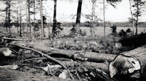
This photo from Wolfeboro, New Hampshire is indicative of the massive tree damage that occurred across northern New England during the Great New England Hurricane of 1938. Photo Credit-Peter Roone-Public Domain.
Odds And Ends
It’s impossible to recreate the depth of this terrible tragedy in words. Here is a video (Public Domain Footage) of the 1938 hurricane on YouTube https://www.weather.gov/okx/1938HurricaneVideo
For those of you who love statistics, here are some 1938 hurricane highlights thanks to the NWS at Upton, New York.
1938 HURRICANE FACTS
Max Recorded Sustained Wind: 121 mph at Blue Hill Observatory, MA
Max Recorded Wind Gust: 186 mph at Blue Hill Observatory, MA
Highest Sustained Wind Measurement (Not Influenced by Terrain) : 109 mph at Fishers Island, NY (Landsea et al 2013)
Lowest Observed Pressure: 27.94 in (946.2 mb) at Bellport, NY
Estimated Lowest Pressure: 27.79 in (941 mb) near Brentwood, NY as the wind and pressure centers were slightly displaced due to its fast speed and extra-tropical transition (Landsea et al. 2013, National Hurricane Center; Hurricane Research Division Re-Analysis Project)
Forward Speed At landfall: 47 mph (Landsea et al. 2013, National Hurricane Center; Hurricane Research Division Re-Analysis Project)
Peak Storm Surge: 17 ft. above normal high tide (Rhode Island)
Peak Wave Height: 50 ft. at Gloucester, MA
Deaths: 700 – Injured: >1,700
Homeless: Approx. 63,000
Homes/Buildings Destroyed: Approx. 8,900
Trees Destroyed: Approx. 2 Billion
Boats Lost or Destroyed: Approx. 3,300
Cost: $620 million (1938 Dollars); Equivalent to 41 billion dollars in 2010. (Blake and Gibney 2011). I
Here is recreated track/intensity (map)… The data is from the National Weather Service

President Franklin D. Roosevelt ordered the Civilian Conservation Corps and the Works Progress Administration to take on the enormous task of cleaning up the destruction. It took two years for the 50 CCC camps and 15,000 WPA workers in the region to complete the task.
Meteorological Conditions
As mentioned earlier, the 1938 hurricane began as a tropical wave that emerged from the African Coast. It became a tropical depression around the Cape (Cabo) Verde Islands and proceeded around the periphery of a subtropical ridge. It probably underwent a rapid strengthening as it passed north of Puerto Rico and became a major hurricane. It became a Category 5 hurricane east of the Bahamas with maximum sustained winds near 160 mph.
It curved north of Puerto Rico and east of the Bahamas under the influence of an upper-atmospheric trough that was moving into the eastern U.S.
The trough continued to deepen on the morning of September 21st, and it became negatively tilted There was a strong high-pressure system to the east. instead of pushing the hurricane out to sea, it basically captured the hurricane and flung it northward.

An upper-level (10,000 ft.) weather map from September 21, 1938, shows a deepening trough in the eastern U.S. (with a negative tilt) capturing a hurricane on the East Coast and directing it northward, Note the high pressure to the east. Map Credit- U.S Weather Bureau.
The hurricane was gradually weakening but its rapid forward speed (over 45 mph) didn’t give it time to weaken below “major” (Category 3) hurricane status. The hurricane moved rapidly northward from off the North Carolina coast in the early morning to Long Island in the early afternoon. Unfortunately, there was little to no warning for this event and shocked residents of Long Island and New England were taken by surprise.
By late afternoon, the hurricane transitioned to a “hybrid” (tropical and non-tropical characteristics). The surface analysis at 5 p.m. showed the center of the storm near Springfield, Massachusetts. there was a definite warm front/cold front structure to the storm. A rapid temperature and dewpoint drop across eastern North Carolina was observed behind the cold front.

A surface weather map from 5 p.m. on September 21, 1938, shows the position of the 1938 hurricane over western Massachusetts with definitive frontal boundaries.
The persistent southerly wind east of the storm kept the devastating storm surge going across eastern Connecticut, Rhode Island, and Long Island.
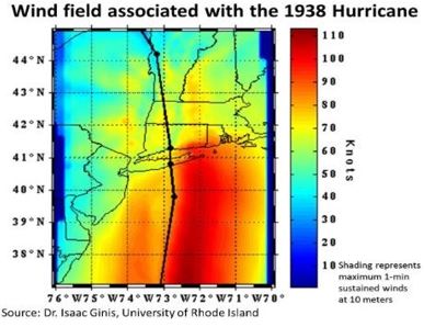
Here is the enacted wind field from the 1938 hurricane (Posted by the NWS from Dr. Ginis URI)) and an enacted storm surge.
The rapid movement of the hurricane held down rainfall totals, but parts of Massachusetts received around a foot of rain which triggered the river flooding.
Because of the incredible damage that this historic hurricane inflicted and the tragic loss of hundreds of lives, a process to better forecast this type of storm and to better warn the public commenced. The process continued through World War II and especially during the 1950s when the East Coast was struck by a number of hurricanes. The launching of the first weather satellite in 1960 (TIROS) was essential in tracking hurricanes and tropical storms across the oceans.

