

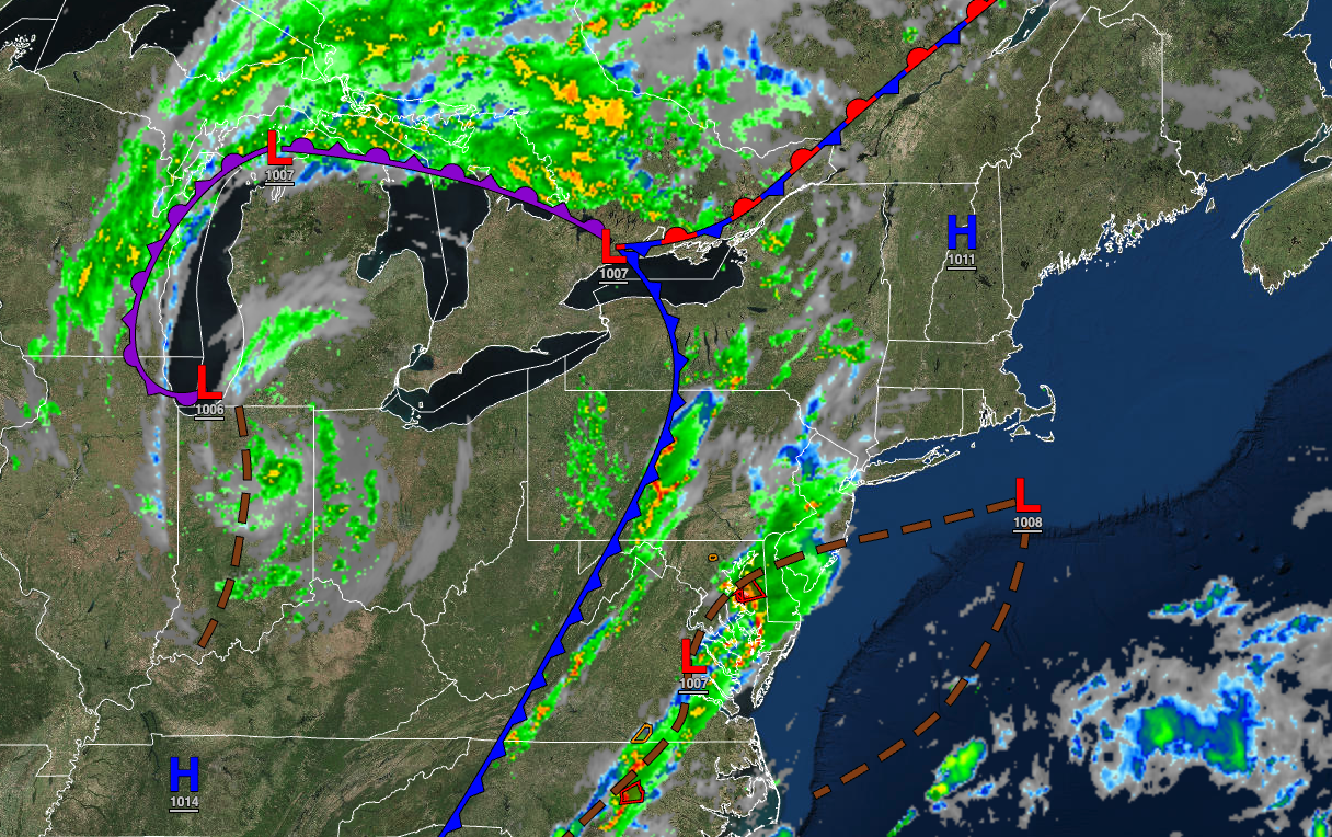
A cold front is on the move, with showers and thunderstorms expected to move through the region through the overnight hours. A few isolated thunderstorms may reach severe levels.
TONIGHT
Scattered showers and thunderstorms will occasionally continue to lift north with heavy downpours. Winds will be from the southwest at 5 to 15 mph. Temperatures will fall into the lower to mid-60s over the interior and mid to upper-60s along the coast for lows.
TOMORROW
A cold front will move through the region with additional showers and thunderstorms through the early afternoon, followed by clearing skies. Winds will veer from the southwest to the west at 5 to 15 mph. Temperatures will rise into the lower to mid-70s over the interior and upper 70s to lower 80s along the coast for highs.
TOMORROW NIGHT
Skies will clear as high pressure slowly build into the region. Winds will be from the west at 5 to 10 mph. Temperatures will fall into the lower to mid-50s over the interior and upper 50s to lower 60s along the coast for lows.
WEDNESDAY
High pressure will build into the region with clearing skies. Winds will be from the west at 5 to 15 mph. Temperatures will rise into the mid to upper 70s for highs.
THURSDAY
High pressure will produce clear skies to scattered clouds. Winds will be from the northwest at 5 to 10 mph. Temperatures will range from the lower to mid-50s over the interior and upper 50s to lower 60s along the coast for lows and mid to upper 60s over the interior and upper 60s to lower 70s along the coast for highs.
FRIDAY AND SATURDAY
High pressure will produce clear skies to scattered clouds. Temperatures on Friday will range from the mid to upper 40s over the interior and lower to mid-50s along the coast for lows and lower to mid-60s over the interior and upper 60s to lower 70s along the coast for highs. Temperatures on Saturday will range from the mid to upper 40s over the interior and lower to mid-50s along the coast for lows and upper 60s to lower 70s for highs.
SUNDAY AND MONDAY
High pressure will exit the region with increasing clouds. Temperatures on Sunday will range from the upper 40s to lower 50s over the interior and lower to mid-50s along the coast for lows and lower to mid-70s for highs. Temperatures on Monday will range from the mid to upper 50s for lows and mid to upper 70s along the coast, upper 70s to lower 80s over the interior, and lower to mid-80s in the Delaware River Valley for highs.
TUESDAY
High pressure off the coast will produce scattered clouds with some morning fog. Temperatures will range from the lower to mid-60s over the interior and mid to upper 60s along the coast for lows and mid to upper 80s for highs.


