

This evening, an impressive heavy rainfall event continues to evolve northwest of the I-95 corridor. More rainfall is on the way through tomorrow, with flash flooding a significant concern due to rainfall amounts of 1″ to 3″.
TONIGHT
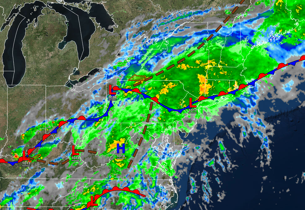
A stationary front with waves of low pressure will continue to produce heavy rainfall throughout northeastern Pennsylvania, northern New Jersey, the Catskills, the Hudson River Valley, and Connecticut, with flash flooding a significant threat. Additional showers capable of heavy downpours will spread southward through the overnight hours. Winds will be from the northeast at 5 to 15 mph. Temperatures will fall into the mid to upper 60s over the interior and upper 60s to lower 70s along the coast for lows.
TOMORROW
An area of low pressure along the stationary front will move through the region with periods of rain, heavy at times. Winds will be from the northeast at 5 to 15 mph. Temperatures will rise into the mid to upper 60s over the interior and lower to mid-70s along the coast for highs.
TOMORROW NIGHT
The stationary front will drop to the south with scattered showers. Winds will be from the northeast at 5 to 15 mph. Temperatures will fall into the lower to mid-60s for lows.
WEDNESDAY
The cold front will sink to the south with scattered showers. Winds will be from the northeast at 5 to 15 mph. Temperatures will rise into the mid to upper 60s over the interior and upper 60s to lower 70s along the coast for highs.
THURSDAY
A trough will linger over the region with scattered cloud cover and isolated showers. Winds will be from the northeast at 5 to 15 mph. Temperatures will range from the lower to mid-60s for lows and mid to upper 70s along the coast, mid to upper 70s over the interior, and upper 70s to lower 80s in the Delaware River Valley for highs.
FRIDAY
High pressure will produce clear skies with a few clouds. Temperatures will range from the upper 50s to lower 60s for lows and upper 70s to lower 80s for highs.
SATURDAY
High pressure will produce clear skies with a few clouds. Temperatures will range from the upper 50s to lower 60s over the interior and lower to mid-60s along the coast for lows and upper 70s to lower 80s over the interior, upper 70s to lower 80s along the coast, and lower to mid-80s in the Delaware River Valley for highs.
SUNDAY
A stationary front will produce scattered clouds with isolated showers. Temperatures will range from the lower to mid-60s for lows and upper 70s to lower 80s over the interior, upper 70s to lower 80s along the coast, and lower to mid-80s in the Delaware River Valley for highs.
MONDAY
A stationary front will produce scattered clouds with isolated showers. Temperatures will range from the lower to mid-60s over the interior and mid to upper 60s along the coast for lows and upper 70s to lower 80s over the interior and lower to mid-80s along the coast for highs.
TUESDAY
A wave of low pressure along the stationary front will produce scattered showers. Temperatures will range from the lower to mid-60s over the interior and mid to upper 60s along the coast for lows and upper 70s to lower 80s over the interior, upper 70s to lower 80s along the coast, and mid to upper 80s in the Delaware River Valley for highs.


