

Intense rainfall through this evening will produce the potential for urban flooding and poor travel conditions. Unsettled conditions this weekend will give way to a warm, tranquil weather pattern next week.
TODAY
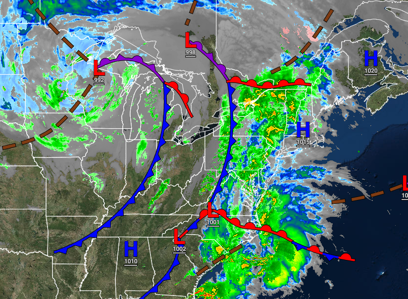
Another area of low pressure will approach with overcast skies and drizzle in the morning giving way to moderate to heavy rainfall and embedded thunderstorms in the afternoon and evening. Rainfall amounts over 1″ are expected for much of the region, possibly reaching up to 3″ in the New York City metropolitan area. Winds will be from the east at 5 to 15 mph with gusts up to 25 mph at times. Temperatures will rise into the mid to upper 40s over the interior, lower to mid-50s in the New York City metropolitan area, and upper 50s to lower 60s in the Philadelphia metropolitan areas for highs.
TONIGHT
Periods of rain will exit after midnight followed by clearing skies and isolated showers towards tomorrow morning. Winds will veer to the west at 5 to 15 mph. Temperatures will fall into the upper 30s to lower 40s over the interior and mid to upper 40s along the coast for lows.
TOMORROW
A series of troughs will produce scattered clouds and lingering isolated showers through the afternoon. Winds will be from the west at 5 to 15 mph with gusts up to 20 mph at times. Temperatures will rise into the mid to upper 50s over the interior and lower to mid-60s along the coast for highs.
SATURDAY
A weak cold front will follow with scattered clouds and isolated showers. Winds will be from the west at 5 to 15 mph. Temperatures will range from the mid-30s over the interior and upper 30s to lower 40s along the coast for lows and upper 40s to lower 50s over the interior and mid to upper 50s along the coast for highs.
SUNDAY
A trough will exit the region with scattered clouds and isolated showers. Temperatures will range from the upper 20s to lower 30s over the interior and mid to upper 30s along the coast for lows and lower to mid-40s over the interior and upper 40s to lower 50s along the coast for highs.
MONDAY THROUGH WEDNESDAY
High pressure will be in control with clear skies to scattered cloud cover. Temperatures on Monday will range from the upper 20s to lower 30s over the interior and mid to upper 30s along the coast for lows and lower to mid-50s over the interior and mid to upper 50s along the coast for highs. Temperatures on Tuesday will range from the upper 30s to mid-40s for lows and mid-50s to lower 60s on Long Island, lower to mid-60s along the coast, and upper 60s to mid-70s away from the coast for highs. Temperatures on Wednesday will range from the lower to mid-50s for lows and upper 60s to lower 70s over the interior, lower to mid-70s along the coast, and mid-70s to lower 80s in the Delaware River Valley for highs.
THURSDAY
An area of low pressure will drive a warm front through the region in the afternoon with scattered clouds and isolated to widely scattered showers and thunderstorms. Temperatures will range from the upper 40s to lower 50s for lows and mid to upper 60s along the coast and lower to mid-70s away from the coast for highs.


