

A rude blast from Old Man Winter won’t last long as warmer weather is on the way for next week.
TODAY
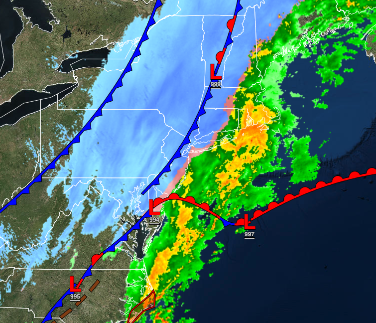
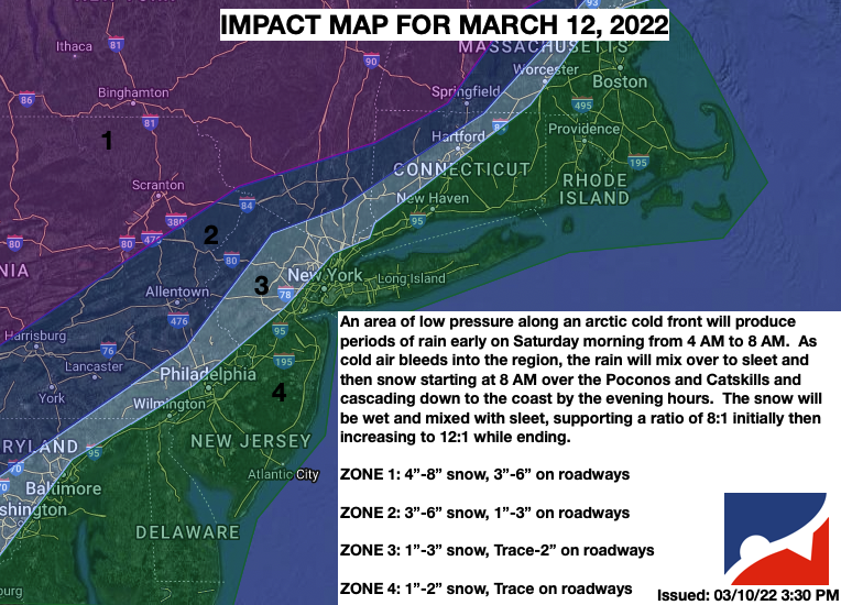
A strong area of low pressure will produce periods of rain, heavy at times, mixing over to snow before ending from west to east. Significant snowfall is expected for higher elevations with over 6″ of snow expected. Mostly rainfall is expected for the Delaware River Valley and to the east, but some minor snow accumulation will be possible on cold surfaces before ending. Winds will back from the southeast to the northwest at 10 to 20 mph with gusts up to 50 mph. Temperatures will fall through the 40s, 30s, and 20s through the day.
TONIGHT
Skies will clear as high pressure begins to build into the region. Winds will be from the northwest at 10 to 20 mph with gusts over 30 mph. Temperatures will fall into the single digits over the interior to the upper 10s to the lower 20s along the coast for lows. A flash freeze of the pavement is expected making for icy conditions.
TOMORROW
High pressure will build into the region with clearing skies. Winds will be from the west at 5 to 15 mph. Temperatures will rise into the lower to mid-30s along the coast for highs.
MONDAY
High pressure will be in control with clear skies to scattered cloud cover. Winds will be from the southwest at 5 to 15 mph. Temperatures will range from the lower 20s over the interior to the lower 30s along the coast for lows and upper 40s over the interior to the mid-50s along the coast for highs.
TUESDAY AND WEDNESDAY
High pressure will shift off the coast with scattered cloud cover expected through the period. Temperatures on Tuesday will range from the mid to upper 30s for lows and mid-50s to lower 60s for highs. Temperatures on Wednesday will range from the upper 20s over the interior to the upper 30s along the coast for lows and lower to mid-50s for highs.
THURSDAY
An area of low pressure will produce periods of showers while moving through the coastal waters. Temperatures will range from the upper 30s to lower 40s for lows and mid to upper 50s for highs.
FRIDAY
High pressure will produce clear skies to scattered cloud cover. Temperatures will range from the lower to mid-40s over the interior to the upper 40s to lower 50s along the coast for lows and mid-60s to lower 70s for highs.
SATURDAY
An area of low pressure will approach with periods of showers, heavy at times towards the evening. Temperatures will range from the lower to mid-40s over the interior and mid to upper 40s along the coast for lows and lower to mid-50s for highs.


