

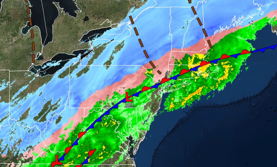
A powerful cold front will provide crashing temperatures and the threat for ice and snow, especially north and west of the I-95 corridor.
TODAY
An arctic cold front with waves of low pressure will slowly move through the region with periods of rain mixing over to sleet and snow from northwest to southeast throughout the day. Snow and ice accumulation will be likely north and northwest of the I-95 corridor, especially for higher elevations. Slick roadways and poor visibility are expected. Winds will veer from the south to the northwest at 5 to 15 mph with gusts up to 20 mph at times. Temperatures will fall through the 50s and 40s into the 20s throughout the day into the evening hours.

TOMORROW
High pressure will build into the region with clearing skies. Winds will be from the northwest at 5 to 10 mph. Temperatures will range from the single digits over the interior to the lower 20s on the coast for lows and mid-10s over the interior to the upper 20s along the coast for highs.
SUNDAY
High pressure will produce clear skies to scattered clouds. Winds will be from the east at 5 to 10 mph. Temperatures will range from the negative single digits to the mid-10s for lows and mid-20s to lower 30s for highs.
MONDAY THROUGH FRIDAY
High pressure will produce clear skies to scattered clouds. Temperatures on Monday will range from the mid-10s over the interior to the lower 30s on the coast for lows and lower to mid-40s for highs. Temperatures on Tuesday will range from the mid-10s over the interior to the lower 30s along the coast for lows and lower to mid-40s for highs. Temperatures on Wednesday will range from the mid-10s over the interior to the mid-20s along the coast for lows and lower to mid-40s for highs. Temperatures on Thursday will range from the lower 20s over the interior to the upper 20s along the coast for lows and lower to mid-40s for highs. Temperatures on Friday will range from the lower 20s over the interior to the upper 20s along the coast for lows and lower to mid-40s for highs.


